RISK ASSESSMENT OF NITRAT CONTAMINATED IN GROUNDWATER IN GIAO THUY DISTRICT, NAMDINH PROVINCE, VIETNAM
on
Risk Assessment of Nitrate Contaminated in Groundwater in Giao Thuy District, Nam Dinh Province, Vietnam
Ly Thi Thu Ha, LTT., An, NT., Ha,NT., Bang,TN.
RISK ASSESSMENT OF NITRATE CONTAMINATED IN GROUNDWATER IN GIAO THUY DISTRICT, NAM DINH PROVINCE, VIETNAM
Ly Thi Thu Ha1*, Ngo The An1, Nguyen Thi Ha2, Tran Nguyen Bang1
1Faculty of natural resources and Environment, Vietnam National University of Agriculture, Trau Quy, Gia Lam, Ha Noi
2Faculty of Environmental Sciences, University of Science, Vietnam National University, Hanoi,
|
Received: |
334 Nguyen Trai, Thanh Xuan, Ha Noi *Corresponding author: lttha@vnua.edu.vn ABSTRACT Environmental pollution due to agricultural production activities, and the use of fertilizers and pesticides is a matter of great concern due to its harmful effects on the soil environment, water environment, and ecosystems. In this study, the risk of nitrate contamination in shallow |
|
5 September 2022 |
groundwater related to agricultural land was evaluated using DRATIC and IPNOA models with 66 soil samples and 132 groundwater samples. The results showed that hazard was found at very low with the hazard index |
|
Accepted: |
(HI) values ranging from 3.5-6.06. The risk index (RI) of nitrate-contaminated groundwater from agricultural activities is in the range of |
|
30 September 2022 |
539 - 1058. The assessment results show that the vulnerability index has a |
|
Published: |
significant impact on the RI, and areas with a high vulnerability index (VI) have a higher risk of groundwater pollution. The NO3- concentration seems to be stable, ranging from 0.02 to 0.11 mg/l, and all meet with the QCVN 09:2018/BNTMT for groundwater quality. No clear correlation between |
|
4 October 2022 |
vulnerability and risk factors with NO3- concentration in groundwater. Key words: agricultural soil, Giao Thuy, groundwater, nitrate contaminated, risk assessment |
INTRODUCTION
Groundwater is an important resource for human life, so the supply of clean water is much concern for many countries and is one of the Sustainable Development Goals of the United Nations (United Nations, 2016). However, groundwater resources are
vulnerable due to pollutants from socioeconomic development activities, including agricultural sources (Huysmans et al., 2006; Zhang et al., 2016). Excessive use of nitrogen fertilizers in agriculture to increase crop yields is a major cause of groundwater pollution (Causape et al., 2006, Gao Y et al.
2012; Yu et al., 2020; Bijay-Singh et al., 2021). On a global scale, nitrogen surpluses continue to be high, with about 50% of nitrogen inputs lost in ecosystems (Liu et al., 2010).
One of the most common chemical contaminants in the world's groundwater has been shown to be nitrate of agricultural origin. In fact, in some places, shallow groundwater has been contaminated with nitrate due to various causes including pollution from agricultural land (Duong Cong Vinh, 2018; Nezhad et al., 2017; X. Zhang, 2013). Serious contamination of groundwater by nitrates has been reported in 30 regions of Africa, 20 regions of Asia, and 9 regions of Europe (Abascal, 2022). The main health hazard from drinking water with nitrates occurs when nitrates are converted to nitrites in the digestive system, causing health effects such as methemoglobinemia in children and stomach cancer in adults (Ludlow, 2019).
Giao Thuy district, Nam Dinh province located in the coastal zone of the Red River Delta of lowland northern Vietnam, and covers an area of 237.76 km2 (People's Committee of Giao Thuy district, 2020). As part of the Red River Delta, this area has two estuaries including Ba Lat and Day where most mangroves are found. Xuan Thuy
eISSN: 2655-9994 pISSN: 2303-3371 https://doi.org/10.24843/IJBB.2022.v10.i01.p05
National Park which is located in the south of the Ba Lat estuary is planned as the core area of the Red river basin region (Thinh & Hens, 2017). In recent years, the structure of land use in the district has changed greatly, but agricultural production still accounts for a significant proportion of the structure of economic development. Giao Thuy district has a high rate of intensive agricultural development, and the abuse of chemical fertilizers has been causing widespread environmental pollution (Ly Thi Thu Ha, 2018a). Figure 1 shows the map of research location.
Previous research studies showed that during 2000-2015 in Giao Thuy district, most crops land surface and water decreased while there was an increased trend in forest land, aquaculture ponds and unused flat land area (Lan, et al., 2017). The major reasons for these changes were policy issues, market, economic, salinity intrusion, climate change and deposits alluvial. Nguyen Thi Phuong Hoa et al (2020a) applied the CLUMondo model to predict agricultural land-use changes to 2030 in the coastal area of Nam Dinh province and found that changes in agricultural land use in 2030 followed scenario 1 (baseline) with a decrease in rice area but increase in the aquaculture area. The
trend was similar in scenario 2 (as the land use planning) but the rice area was more decreased. Besides, Nguyen Thi Phuong Hoa et al (2020b) also determined driving forces for agricultural land use changes in Nam Dinh province were the land use policies, household economy, market price, and climate changes. However, accurate information on how chemical fertilizer affect to groundwater is still undetermined, also there is currently a knowledge gap on risk of ground water area in Giao Thuy district.
This study was conducted with the aim of identifying vulnerable groundwater areas due to the excessive use of chemical fertilizers in agricultural cultivation in Giao Thuy district. For this reason, groundwater contamination risk is associated with the intrinsic vulnerability of the aquifer and the hazard factors (nitrate load on the soil), the control factors (Padovani & Trevisan, 2002; Li Xinyan et. al, 2020). This research result helps managers make urgent plans to protect groundwater, high-risk areas are prioritized in research to protect groundwater resources, towards development sustainability for the coastal area of the Red river delta.
METHODS
Sample collection and analysis
For IPNOA model inputs, 66 soil samples were collected from the agricultural area in 22 communes and towns of Giao Thuy district to analyze the nitrogen content. Samples were taken in the cultivation layer at 0 – 10 cm depth. Soil samples were sieved through a 2mm sieve to remove large plants and dried at 1050C for 24 hours. The total nitrogen parameter was analyzed by the Kjeldahl method with the Alpkem autoanalyzer (Piper, 2019). To confirm the results of the nitrate contamination risk model in groundwater, 132 well samples were collected in the study area. The nitrate concentration metric in the water sample was analyzed using a spectrometric method using sulfosalicylic acid.Figure 2 shows map of sample locations.
Groundwater risk assessment method
Hazard assessment of nitrate contaminated groundwater was calculatedusing IPNOA model. The IPNOA model was used to assess the hazard of nitrate-contaminated groundwater due to agricultural sources (Padovani & Trevisan, 2002). The risk factors include nitrogen inputs from agriculture such as chemical fertilizers (HFfm), organic fertilizers (HFfo) and sewage sludge (HFfd) (see Table 1). Calculation of fertilizer use per area unit
based on crop data and district statistical yearbooks.
The actual amount of used fertilizer was investigated in 22 communes in the study area with 30 households randomly selected
for the survey in each commune. The factors influencing the nitrogen leaching process were assessed through nitrogen content in soil (CFa), irrigation technique (CFi), climate (CFc), and agronomic practices (CFpa) are presented in Table 2.
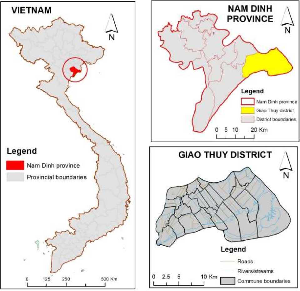
Figure 1. Map of the study area
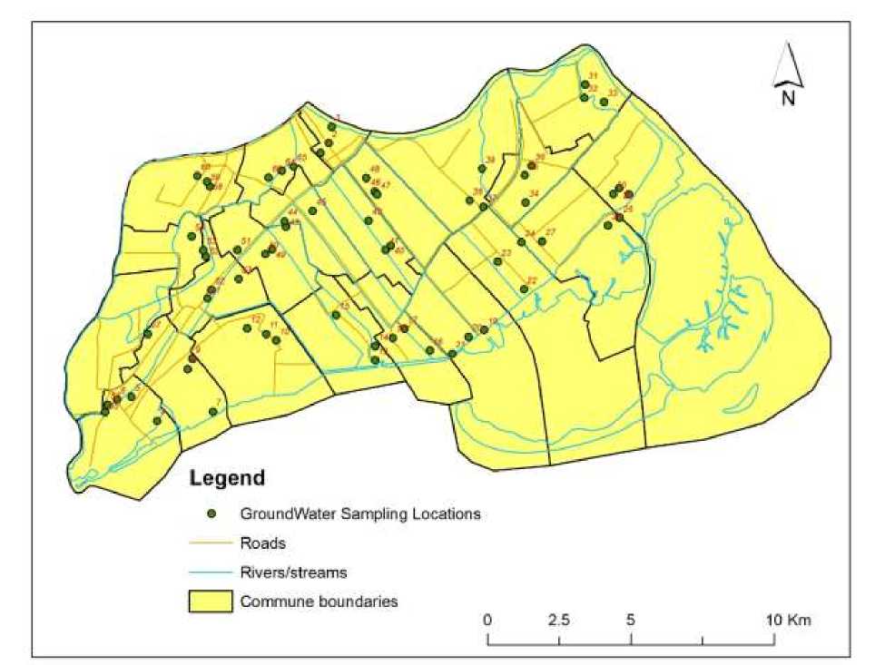
Figure 2. Map of Sample Locations
Table 1. Hazard Classes Corresponding to the Amount of Fertilizer from Different Sources
|
Nitrogen from chemical fertilizers (kg/ha/year) |
Nitrogen from organic fertilizers (kg/ha/year) |
Nitrogen from sewage sludge (kg/ha/year) |
Hazard classes HFfm /HFfo /HFfd |
|
0 |
0 |
0 |
1 |
|
1-25 |
1-150 |
1-150 |
2 |
|
>25-100 |
>150-300 |
>150-500 |
3 |
|
>100 – 180 |
>300-500 |
>500-1500 |
4 |
|
>180 |
>500 |
>1500 |
5 |
The pollution hazard index (HI) of nitrate in groundwater evaluated by the IPNOA model is calculated by multiplying
the risk factors (HF) by the influencing factors (HC) as equation (1):
HI Index = (HFfm + HFfo + HFfd) x (CFa x CFcx CFpa x CFi)
(1)
Table 2. Control Factors and Associated Hazard Classes
|
Soil Nitrogen Content (%) |
CFa |
Irrigation system |
CFi | ||
|
>0.5 |
1.04 |
Flood |
1.06 | ||
|
0.22-0.5 |
1.02 |
Drip |
1.04 | ||
|
0.15-<0.22 |
1.00 |
Furrow |
1.01 | ||
|
0.1-<0.15 |
0.98 |
No irrigation |
1.00 | ||
|
<0.1 |
0.96 | ||||
|
Tillage |
Fertilization |
CFpa |
Rain (mm/year) |
T (0C) |
CFc |
|
/ |
Fertiirrigation |
1.04 |
>1200 |
6-15 |
1.10 |
|
Traditional Fertilizer |
1.00 |
1050-1150 |
13 |
1.08 | |
|
tillage |
Spreaders | ||||
|
/ |
Foliar fertilization |
0.98 |
950-1100 |
14-16 |
1.06 |
|
Minimum |
Local |
0.96 |
800-1000 |
12 |
1.04 |
|
tillage No tillage |
fertilization |
0.94 |
600 -1000 |
15-16 |
1.02 |
|
600-800 |
12-13 |
1.00 | |||
|
500-900 |
>16 |
0.98 | |||
|
600-700 |
13-14 |
0.96 | |||
|
<600 |
15-17 |
0.94 | |||
The values of the HI index were then classified into six classes from 1 to 6 (Padovani & Trevisan, 2002) associated with
six potential hazard ratings from improbable to very high hazards present in Table 3.
Table 3. Values and descriptions of environmental hazards
|
Hazard class |
HI Index |
Pollution hazard |
|
1 |
2.54-3.18 |
Improbable |
|
2 |
3.19-5.88 |
Very low |
|
3 |
5.89-7.42 |
Low |
|
4 |
7.43-9.31 |
Moderate |
|
5 |
9.32-11.10 |
High |
|
6 |
11.11-17.66 |
Very high |
Risk assessment of nitrate contamination in groundwater from agricultural activities using the two models of DRATIC (Aller, 1987) and IPNOA were
combined to assess the risk of nitrate contamination in aquifers from agricultural activities. The potential risk index (RI) is assessed by the value of groundwater
vulnerability index (VI), and the value of the risk index of nitrate contamination in groundwater (HI) using equation (2).
RI = VI * HI …………………………………………………………………………………….(2)
RESULTS AND DISCUSSION
Assessment of the hazard of nitrate contamination in groundwater from agricultural production activities
This research found that agricultural production activities in Giao Thuy district do not involve the use of organic fertilizers and also there is no sludge storage area. The Hfm hazard index was calculated from the amount of fertilizer used in agricultural cultivation and data on the type of crop, and the cultivated area in the study area. The results of calculating the amount of fertilizer used in farming show that the amount of fertilizer used is the most in Giao Tien, Giao Hai, and Giao Nhan communes (969.2; 922.4 and 917.6 kg/ha/year, respectively). These communes have a large percentage of arable land. Quat Lam and Ngo Dong towns have the lowest fertilizer use (51.8 and 81 kg/ha/year, respectively) due mainly to land for housing construction, receiving the 3rd
rank. Other communes with fertilizer use in the range of 231.8 to 857.2 kg/ha/year, received a rank of 5.
Sources of information on the assessment of control factors (HCs) are collected from surveys, results of soil nitrogen analysis or from the district's agricultural management office. The results of soil N analysis showed that the communes of Giao Phong, Giao Long, Bach Long, Giao Yen and Quat Lam town had nitrogen content in the soil ranging from 0.36 to 0.44%. These are the communes that grow vegetables or rotate vegetables -rice, with irrigation systems, less tillage, and fertilizing at the base. Other communes with nitrogen contents in the soil > 0.5%, are the communes that grow rice, have traditional irrigation, and spread fertilization systems. The results of the evaluation of control parameters, the HI index, and the hazard level of nitrate contamination in groundwater are shown in Table 4.
Table 4. HI index and assessment of the hazard of nitrate contamination in groundwater at Giao Thuy district
|
Commune/Town |
HFfm |
CFa |
CFi |
CFpa |
CFc |
Hazard Index (HI) |
Hazard |
|
Giao Phong |
5 |
1.02 |
1.04 |
0.96 |
1.10 |
5.60 |
Very low |
|
Giao Long |
5 |
1.02 |
1.04 |
0.96 |
1.10 |
5.60 |
Very low |
|
Bach Long |
5 |
1.02 |
1.04 |
0.96 |
1.10 |
5.60 |
Very low |
|
Giao Hai |
5 |
1.04 |
1.06 |
1.00 |
1.10 |
6.06 |
Low |
|
Giao Xuan |
5 |
1.04 |
1.06 |
1.00 |
1.10 |
6.06 |
Low |
|
Hong Thuan |
5 |
1.04 |
1.06 |
1.00 |
1.10 |
6.06 |
Low |
|
Quat Lam |
3 |
1.02 |
1.04 |
1.00 |
1.10 |
3.50 |
Very low |
|
Ngo Dong |
3 |
1.04 |
1.06 |
1.00 |
1.10 |
3.64 |
Very low |
|
Giao An |
5 |
1.04 |
1.06 |
1.00 |
1.10 |
6.06 |
Low |
|
Giao Thien |
5 |
1.04 |
1.06 |
1.00 |
1.10 |
6.06 |
Low |
|
Giao Lac |
5 |
1.04 |
1.06 |
1.00 |
1.10 |
6.06 |
Low |
|
Giao Nhan |
5 |
1.04 |
1.06 |
1.00 |
1.10 |
6.06 |
Low |
|
Giao Tien |
5 |
1.04 |
1.06 |
1.00 |
1.10 |
6.06 |
Low |
|
Giao Chau |
5 |
1.04 |
1.06 |
1.00 |
1.10 |
6.06 |
Low |
|
Giao Huong |
5 |
1.04 |
1.06 |
1.00 |
1.10 |
6.06 |
Low |
|
Binh Hoa |
5 |
1.04 |
1.06 |
1.00 |
1.10 |
6.06 |
Low |
|
Hoanh Son |
5 |
1.04 |
1.06 |
1.00 |
1.10 |
6.06 |
Low |
|
Giao Ha |
5 |
1.04 |
1.06 |
1.00 |
1.10 |
6.06 |
Low |
|
Giao Yen |
5 |
1.02 |
1.04 |
0.96 |
1.10 |
5.60 |
Very low |
|
Giao Thanh |
5 |
1.04 |
1.06 |
1.00 |
1.10 |
6.06 |
Low |
|
Giao Tan |
5 |
1.04 |
1.06 |
1.00 |
1.10 |
6.06 |
Low |
|
Giao Thinh |
5 |
1.04 |
1.06 |
1.00 |
1.10 |
6.06 |
Low |
Assessment results of the hazard factors
of the area. The remaining 14 communes
(chemical fertilizers, organic fertilizers, sewage sludge) and the control factors (N soil, irrigation patterns, agronomic practices, and climate) showed that there are 6 communes/towns that have a very low hazard of nitrate pollution in groundwater from agricultural activities (Giao Phong, Giao Long, Bach Long, Giao Yen and Ngo Dong town, Quat Lam town) accounting for 15.4%
have a low risk of nitrate pollution, accounting for 84.6% of the district's area.
Meanwhile, in a recent study, the results of the assessment of intrinsic vulnerability index (VI) in Giao Thuy district were obtained through seven geological and hydrological data sources ranging from 134 to 189. There are three communes assessed as highly vulnerable (189 points) including
Giao Phong, Giao Long, and Bach Long communes. The remaining towns/communes have ranked at moderate vulnerability (VI values range from 134 to 154 points) (Ly Thi Thu Ha, 2018b) accounting for 8.6 and 91.4% of the total natural land area of the district, respectively. The communes with high vulnerability mainly belong to hydrological soil group A and have low groundwater depth. Low vulnerability communes belong to communes with hydrological soil group C and high groundwater depth (Ly Thi Thu Ha, 2018b).
Communes that are assessed to have high intrinsic vulnerability such as Giao Phong, Giao Long and Bach Long have a low hazard of pollution. The reason why some communes/towns have high vulnerability assessment scores is that the hazard of nitrate pollution in groundwater from agricultural activities is very low because these are mostly vegetable-growing areas, with sandy soils, therefore nitrogen concentration in the soil is lower (Onweremadu, 2015). In addition, the agricultural practice in these communes is irrigation drip and minimum tillage, and local fertilization means less hazard of nitrogen leaching into groundwater.
Risk assessment of shallow groundwater in Giao Thuy district
The RI of nitrate-contaminated groundwater from agricultural activities ranges from 539.0 to 1058.4. The level of risk of groundwater pollution in the study area is confirmed mainly at a moderate rate with an area accounting for 87.3% of the total study area. High pollution risk including Giao Phong, Giao Long, and Bach Long communes accounted for 8.6%, and low-risk level communes of Quat Lam town and Ngo Dong town accounted for 4.1% of the total study area. The assessment results show that the vulnerability index has a significant impact on the RI index, and areas with a high vulnerability index have a higher risk of groundwater pollution.
Interestingly, it‘s obvious that some areas have high vulnerability to groundwater but there is no distribution of pollution sources, so the risk of groundwater pollution is still low, such as in Ngo Dong and Quat Lam towns. Some regions with low vulnerability still have a high risk of groundwater pollution due to high nitrogen fertilizer use, such as Giao Hai, Giao Xuan, and Hong Thuan communes. Therefore, the amount of nitrogen fertilizer used in farming could be a
major contributor to the increased risk of groundwater contamination in the area. The assessment results also show very high pollution risk areas when the source of high pollutant load is located in vulnerable areas (Q. Zhang, 2022), such as Giao Phong, Giao Long and Bach Long communes.
There are many studies showing that agriculture is related to nitrate pollution in groundwater (Hansen, 2012; Mahvi, 2005).. Take 132 well sample samples to evaluate the relationship between nitrate concentration in groundwater with pollution risk index. The result of NO3- analysis groundwater samples in two towns and 20 communes of Giao Thuy district showed that the concentration of NO3-did not fluctuate much, from 0.02 to 0.11 mg/l, all below the permissible standards
(QCVN 09:2018/BNTMT on groundwater quality). However, Giao Phong, Giao Long, Bach Long, Giao Hai and Giao Xuan communes had higher concentrations of NO3-in groundwater, ranging from 0.07 to 0.11 mg/l which is consistent with the communes assessed as having the highest risk. These are all much lower than reported in the study of Zhang (Zhang, 2013) where the average NO3--N concentrations in agro-ecosystems and forest ecosystems were found high at 4.1 ± 0.33 and 0.5 ± 0.04 mg/l, respectively. In the agricultural ecosystems, about 25% of surveyed wells (10/43 wells) NO3--N concentrations found greater than 10 mg N/l. The risk maps of VI, HI, RI, and NO3- are present in Figure 3.
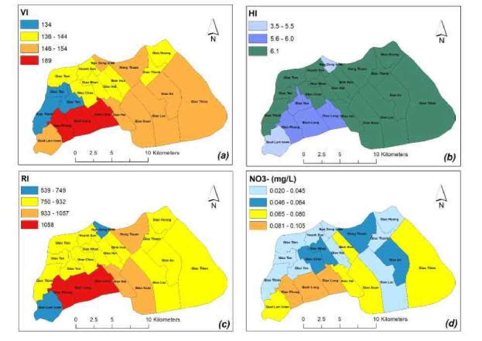
Figure 3. Risk Maps (a) VI, (b) HI, (c) RI, and (d) NO3- for Giao Thuy District
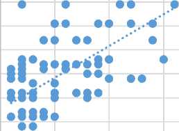
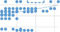
The Pearson correlation coefficient (Pearson, 1896) was calculated to assess the correlation between vulnerability and risk factors with nitrate concentrations in groundwater. Pearson's use of correlation coefficient (r) showed a clear linear correlation (r=0.60) between vulnerability and nitrate concentrations in groundwater (Figure 4a),
and the risk values for groundwater contamination by nitrates have a low correlation coefficient (r=0.34) (Figure 4b). Low r values in Figure 4b show almost no correlation between vulnerability factor (a) and risk factor (b) with NO3- concentration in groundwater.
(a)
230
220
1200
1000
210
200
190
180
170
160
0 0,05 0,1 0,15
150
0,2
NO3- (mg/l)
X (D
C
800
600
400
200
0
0
∙∙∙∙∙
0,05 0,1 0,15 0,2
NO3- (mg/l)
Figure 4. Relationship Between Vulnerability Factor
(a), Risk Factor (b) and NO3- Concentration in Groundwater in Giao Thuy district
CONCLUSION
The results of the risk assessment for shallow groundwater related to nitrogen content in soil and nitrate in groundwater showed that groundwater has not been contaminated with nitrate, ranging from 0.02 to 0.11 mg/l, and all meet with the QCVN 09:2018/BNTMT for groundwater quality. Calculation results
show that the risk level is low and very low. The HI values found ranging from 3.5 to 6.06. The RI of nitrate-contaminated groundwater from agricultural activities in the range of 539 - 1058. It was observed, no clear correlation between vulnerability and risk factors with NO3- concentration in groundwater.
REFERENCES
Abascal, E., Gómez-Coma, L., Ortiz, I., & Ortiz, A. (2022). Global diagnosis of nitrate pollution in groundwater and review of removal technologies. Science of The Total Environment, 810, 152233.
doi:https://doi.org/10.1016/j.scitoten v.2021.152233
Aller, L., Bennett, T., Lehr, J., Petty, R., & Hackett, G. (1987). DRASTIC: A standardized system for evaluating groundwater pollution potential using hydrogeologic settings. U.S.
environmental protection agency report 600/2- 87/035, p 622
Bijay-Singh, Craswell, E. Fertilizers and nitrate pollution of surface and ground water: an increasingly
pervasive global problem. SN Appl. Sci. 3, 518 (2021).
https://doi.org/10.1007/s42452-021-04521-8Causape, J., Quilez, D., & Aragues, R. (2006). Groundwater quality in CR-V irrigation district (Bardenas I, Spain): Alternative scenarios to reduce off-site salt and nitrate contamination. Agricultural
Water Management, 84(3), 281–289. https://doi.org/10.1016/j.agwat.2006. 03.004
People's Committee of Giao Thuy district. (2020). L-C (Land – Climate)
Statistic year book, Giao Thuy distric, Nam Dinh province. People's
Committee of Giao Thuy district.
Duong Cong Vinh, T. H. L. (2018). Level of nitrate on shallow groundwater in Pleiku City. Level of nitrate on shallow groundwater in Pleiku City. Ho Chi Minh Nong Lam University (https://www.researchgate.net/public ation/344361212_ ).
Gao Y, Yu G, Luo C, Zhou P (2012). Groundwater nitrogen pollution and assessment of its health risks: a case study of a typical village in rural-urban continuum, China. PLoS One. 2012;7(4):e33982. doi:
10.1371/journal.pone.0033982.
Epub. PMID: 22514611; PMCID: PMC3326077
Guimei Yu, Jiu Wang, Lei Liu, Yun Li, Yi Zhang and Songsong Wang. The analysis of groundwater nitrate pollution and health risk assessment in rural areas of Yantai, China BMC Public Health (2020) 20:437
https://doi.org/10.1186/s12889-020-08583-y
Hansen, B., Dalgaard, T., Thorling, L., Sørensen, B., & Erlandsen, M.
(2012). Regional analysis of groundwater nitrate concentrations and trends in Denmark in regard to
agricultural influence.
Biogeosciences, 9(8), 3277-3286.
Huysmans, M., Madarász, T. & Dassargues, A. Risk assessment of groundwater pollution using sensitivity analysis and a worst-case scenario analysis. Environ Geol 50, 180–193 (2006).
https://doi.org/10.1007/s00254-006-0197-1
Lan, Nguyen & Osawa, Takahiro & Nuarsa, I Wayan & An, Ngo. (2017). Land Cover Change Detection Using Landsat Data in Giao Thuy District, Nam Dinh Province, Vietnam. International Journal of Environment and Geosciences. 1.
10.24843/ijeg.2017.v01.i01.p03.
Li Xinyan, Wu Hao, Qian Hui. (2020). Groundwater contamination risk assessment using intrinsic
vulnerability, pollution loading and groundwater value: a case study in Yinchuan plain, China.
Environmental Science and Pollution Research. 27. 10.1007/s11356-020-
10221-4.
Liu, J., You, L., Amini, M., Obersteiner, M., Herrero, M., Zehnder, A. J., & Yang, H. (2010). A high-resolution assessment on global nitrogen flows in cropland. Proceedings of the National Academy of Sciences, 107(17), 8035-8040.
Ludlow, J. T., Wilkerson, R. G., & Nappe, T. M. (2019). Methemoglobinemia, StatPearls Publishing, Treasure Island.
Ly Thi Thu Ha, N. T. A., Nguyen Thi Ha. (2018). Assessing ground water vulnerability from nitrogen leaching in cultivated areas of Giao Thuy District, Nam Dinh province. Journal of Agriculture and Rural Development, 12, 67-75.
Ly Thi Thu Ha, N. T. A., Nguyen Thi Ha, Andreas, Minghua Zhou, Nicolas Brüggemann, Wolf-Anno Bischoff (2018). Nitrogen leaching on intensive vegetable production area of Giao Thuy district, Nam Dinh province. Journal of Agriculture and Rural Development, 24, 153-160.
Mahvi, A., Nouri, J., Babaei, A., &
Nabizadeh, R. (2005). Agricultural activities impact on groundwater nitrate pollution. International Journal of Environmental Science & Technology, 2(1), 41-47.
Nezhad, A. B., Emamjomeh, M. M., Farzadkia, M., Jafari, A. J., Sayadi, M., & Talab, A. H. D. (2017). Nitrite and nitrate concentrations in the drinking groundwater of Shiraz City, South-central Iran by statistical models. Iranian journal of public health, 46(9), 1275.
Nguyen Thi Phuong Hoa, Ngo The An, Le Thi Giang (2020a). Agricultural land use change in coastal areas of Nam Dinh province in 2015-2019 from remote sensing and GIS. Vietnam Soil Science, 58, 110-116.
Nguyen Thi Phuong Hoa, Ngo The An, Le Thi Giang (2020b). Driving forces of agricultural land use change in coastal areas of Nam Dinh province. Vietnam Soil Science, 60, 82-87
Onweremadu, E. U., C.M. Ahukaemere, O.A. Orji. (2015). Horizon Differences in Selected Physical Properties of Soils formed Over Dissimilar Lithologies in South Eastern Nigeria. FUTO Journal Series (FUTOJNLS), VOL. 1(2) 55 – 61.
Padovani, L., Trevisan, M., (2002). I nitrati di origine agricola nelle acque sotterranee. Quaderni di tecniche di
protezione ambientale, n. 75, pp. 120, Pitagora Editrice, Bologna.
Pearson, K. (1896). VII. Mathematical contributions to the theory of evolution.—III. Regression, heredity, and panmixia. Philosophical Transactions of the Royal Society of London. Series A, containing papers of a mathematical or physical character(187), 253-318.
Piper, C.S. (2019). Soil and Plant Analysis. Scientific publisher.
Thinh, N. A., & Hens, L. (2017). A Digital Shoreline Analysis System (DSAS) applied on mangrove shoreline changes along the Giao Thuy coastal area (Nam Dinh, Vietnam) during 2005-2014. Vietnam Journal of Earth Sciences, 39(1), 87-96.
United Nations. (2016). Sustainable Development Goals: A need for relevant indicators. Ecological Indicators, 60, 565-573.
Zhang, Q., Li, P., Lyu, Q., Ren, X., & He, S. (2022). Groundwater contamination risk assessment using a modified DRATICL model and pollution loading: A case study in the
Guanzhong Basin of China. Chemosphere, 291, 132695.
Zhang, X., Xu, Z., Sun, X., Dong, W., & Ballantine, D. (2013). Nitrate in shallow groundwater in typical agricultural and forest ecosystems in China, 2004–2010. Journal of Environmental Sciences, 25(5), 10071014.
Zhang, X., Sun, M., Wang, N. et al. Risk assessment of shallow groundwater contamination under irrigation and fertilization conditions. Environ Earth Sci 75, 603 (2016).
https://doi.org/10.1007/s12665-016-5379-x
50
Discussion and feedback