SPATIAL ANALYSIS OF LANDSLIDE POTENTIAL ON AGRICULTURE IN THE AYUNG WATERSHED, BALI PROVINCE
on
Spatial Analysis of Landslide Potential on Agricultural in The Ayung...,
[Feronika, dkk]
SPATIAL ANALYSIS OF LANDSLIDE POTENTIAL ON AGRICULTURE IN THE AYUNG WATERSHED, BALI PROVINCE
Feronika1*), Takahiro Osawa2), I Nyoman Merit3)
1)Master's Degree Program in Environmental Science, Udayana University 2)Center for Research and Application of Satellite Remote Sensing (YUCARS), Yamaguchi
University
3)Master's Degree Program in Environmental Science, Udayana University
*Email: feronika94@gmail.com
ABSTRACT
The Ayung Watershed is one of the watersheds with mountainous and hilly landscapes with potential landslides. This study aims to determine the potential level of landslide susceptibility and its effect on agricultural land use in the Ayung watershed. The method used to determine the potential for landslides is a weighting/scoring method by overlapping the parameters causing landslides, namely rainfall, slope, land use, landform, geological structure, and soil type. Determining the effect of landslide potential on agricultural land is done by overlapping the landslide potential map with land use. The data used includes BMKG monthly rainfall for 2015-2019, the slope of DEMNAS data for 2020, geological structure and landform 1:25,000 scale RBI map data for 2019, land use using Sentinel 2A data for 2020, and soil types in the form of spatial planning maps Province of Bali 1:25,000 scale in 2019. The results showed that landslides in the Ayung watershed were categorized as low potential to high potential. Classes with no landslide potential are widespread in the upstream and downstream areas of the watershed, covering an area of 18,976.01 ha (60%), the low potential category covering 5,877.78 ha (19%), the medium potential category covering an area of 3,208.76 ha (10%) and the low potential category covering an area of 3,208.76 ha (10%) spread over the upstream and central parts of the watershed covering an area of 3,528.55 ha (11%). The effect of landslides on agricultural land has a category from no potential to high potential. The category with no potential is widespread in the upstream watershed area of 13,268.57 ha (66%), the low potential category is 3,268.57 ha (16%), the medium potential category is 1,782.31 ha (9%), and the high category is spread in the upstream and the middle of the watershed area of 1,707.28 ha (9%).
Keywords: Landslide; Watershed; Mapping; Agricultural land.
Natural disasters are natural events that can occur suddenly or slowly, anywhere and anytime, and cause material and non-material losses. In Indonesia, natural disasters in the form of landslides can be found in every watershed, especially upstream. One of the causes of landslides is a very steep topography
(Arsyad, 2012). This situation is due to the state of the upstream watershed which has a very steep slope (Indarto, 2010). Human activities in watersheds also exacerbate this. Human activities such as residential development, industry, expanding administrative areas, and conversion of forest area functions can increase land, reduce slope instability and open vegetation, and the lack of
application of soil and air conservation techniques. Watersheds are generally defined as overlays of areas/areas bounded by topographical barriers (ridges) that receive, and accommodate rainwater, sediments, and nutrients and drain them through tributaries out of the main river into the sea or lake (Asdak, 2007). The Ayung watershed is the largest watershed on the island of Bali and has great potential to be exploited.
Administratively, the Ayung watershed in the north originates in Bangli, Badung, Buleleng, and Tabanan regencies, flows through Gianyar and Badung regencies, and runs out into the south at Denpasar City. Ayung watershed has an area of 31.591,08 ha.
Factors that cause landslides include passive factors and active factors (Cook & Dornkampm, 1994). Passive factors control the occurrence of landslides, while active factors trigger landslides (Thornbury, 1969). Passive factors include topography, soils, geological/lithological conditions, hydrological conditions, previous landslides, and vegetation. Active factors that influence the occurrence of landslides include human activities in land use and climatic factors. In this study, the passive factors used include topographic factors, geological structures, landforms, and soil types, while the active factors are land use and climatic factors such as rainfall.
To obtain the zoning of the landslide potential area in the Ayung watershed, a weighting/scoring method referred to (Nursa'ban 2008) was carried out from the parameters that were a factor in the occurrence of landslides, and to obtain the landslide-affected agricultural land, an overlay was made between the land use map and the map of the landslide potential area in the Ayung watershed. This study
aims to prepare maps of potential landslides and maps of agricultural land affected by landslides in the Ayung watershed by applying Sentinel 2A imagery, DEMNAS, and other secondary data. The mapping of potential landslide zones can be calculated based on the spatial integration of the parameters that influence and trigger landslides (Khosiah & Ariani, 2017). To obtain the required parameters, remote sensing based on image processing Sentinel 2A, DEMAS, and available secondary data could be employed to obtain the required parameters. This processing can produce landslide potential area zoning based on parameters caused by passive and active factors that cause landslide disasters in spatial form. The results obtained can be used as an effort to reduce the impact caused by landslides (Althuwaynee, 2012)
The research was conducted in the Ayung watershed, which is located between 115°07’27’BT - 115°20,18,,BT and 08°12,16',LS-08°44,31''LS (Figure 1). The flow of the Ayung watershed passes through four regencies/cities, namely Bangli, Gianyar, Badung and, Denpasar City.
The data used in this study include rainfall data (month, 2015-2019) from BMKG, DEMNAS 8.1 meter resolution, RBI Map (Map of landforms, geological maps, and soil types in 2019), and Land use (Sentinel-2A) resolution of 10 meters time 09.25 AM.
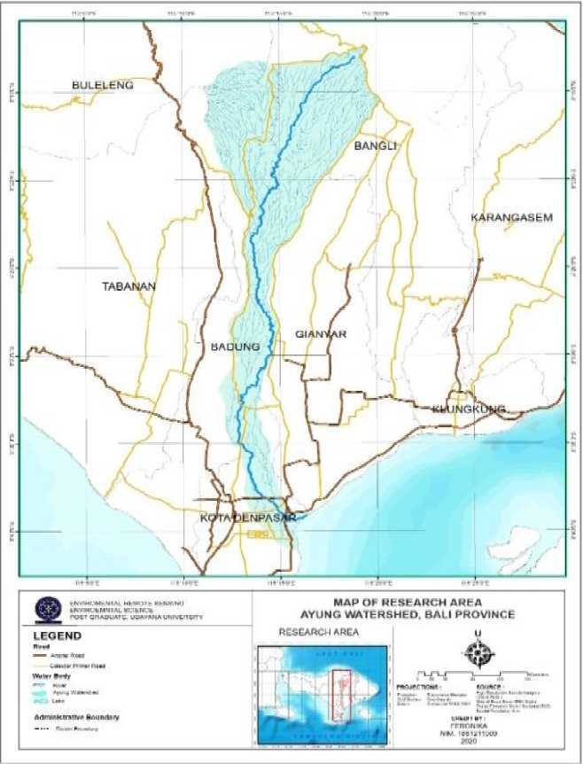
Figure 1.
Research Location
The preparation stage includes literature study activities to obtain references related to landslides, geographic information systems theory, remote sensing theory, and procedures for using Qgis 2.14.21 applications.
Thematic maps are inserted to make it easier to analyze the potential for landslides from data that has not been in the form of a shapefile. Several thematic
maps were made, including rainfall, slope, geological structure, landform, land use, and soil type maps.
-
A. Scoring
The landslide potential assessment in this study is parametric, each parameter is classified into several classes and a score is given to each parameter used. The scores are presented in Table 1 to Table 6. A score of 1 reflects a minimal contribution to the landslide process. In contrast, a score of 5 dramatically contributes to the landslide.
Table 1. Rainfall Score
|
No |
Rainfall (mm/th) |
Score |
|
1 |
< 1.500 |
1 |
|
2 |
1.500 - 1.800 |
2 |
|
3 |
1.800 - 2.100 |
3 |
|
4 |
2.100 - 2.400 |
4 |
|
5 |
> 2.400 |
5 |
Source: (Pradnyasari, 2019) with
modification
Table 2. Slope Score
|
No |
Slope Angle (%) |
Slope (%) |
Score |
|
1 |
0 - 8 |
Flat |
1 |
|
2 |
8 - 15 |
Sloping |
2 |
|
3 |
15 – 30 |
A Little |
3 |
|
Steep | |||
|
4 |
30 – 45 |
Steep |
4 |
|
5 |
>45 |
Very Steep |
5 |
Source: (Pradnyasari, 2019) with
modification
Table 3. Geological Structure Score
|
No |
Geologi Structure |
Skor |
|
1 |
Horizontal |
1 |
|
2 |
Horizontal/Tilted |
2 |
|
3 |
Tilted |
3 |
|
4 |
Cracks |
4 |
|
5 |
Lean Steep |
5 |
|
Source: (Pradnyasari, modification Table 4. Land-Use Score |
2019) with | |
|
No |
Land-Use |
Skor |
|
1 |
Forests, mangroves, swamps, irrigated rice fields, ponds, salting, sand |
1 |
|
2 |
Rainfed rice fields |
2 |
|
3 |
Buildings, settlements |
3 |
|
4 |
Shrubs, gardens/plantations |
4 |
|
5 |
Grass, bare land, moor/fields |
5 |
Source: (Pradnyasari, 2019) with
modification
Table 5. Landform Score
|
No |
Landform |
Score |
|
1 |
Alluvial Plains |
1 |
|
2 |
Limestone Hills, Caldera, Volcanic Foot Slopes, Hills, Lower Slopes |
2 |
|
3 |
Lower Volcanic Slopes, Lower Hills Slopes, Middle Slopes, Inter-Mountain Plains, Rugged Slope Mountains |
3 |
|
4 |
Middle Volcanic Slope, Upper Hills Slope, Volcanic Slope |
4 |
|
5 |
Volcanic Cones, Upper Volcanic Slopes, Volcanic Lungur, Valleys, Caldera |
5 |
Source: (Pradnyasari, 2019) with
modification
Table 6. Soil Type Score
|
No |
Soil Type |
Score |
|
1 |
Mediterranean Brown, Mediterranean Reddish Brown |
1 |
|
2 |
Yellowish Brown Latosol, Reddish Brown Latosol, and Litosol |
2 |
|
3 |
Chocolate Latosol and Litosol, Brown Gray Alluvial, Alluvial Hydromorph |
3 |
|
4 |
Brown Regosol, Yellowish Brown Regosol, Grey Brown Regosol, Regosol Humus, Grey Regosol |
4 |
|
5 |
Grey Brown Andosol |
5 |
Source: (Pradnyasari, 2019) with
modification
The potential landslide score is obtained by overlapping all the above landslide-causing parameters. Assign weights to parameters based on the factor itself; the dynamic is given a higher value weight because landslide events are always triggered by changes in force due to changes in dynamic factors. The calculation of the cumulative score in this research, referring to Pradnyasari (2019) which
has been modified according to field conditions with the weighting formula used is as follows:
Avalance Potential Score=(6score L)+ (5 score S)+ (5score R)+ (4 score LU)+ (3score GS)+
(2 score ST ) ................................................
(1)
Where:
L/S/R/LU/GS/ST;
Landform(L)/Slope(S)/Raifall(R)/Lad-use(LU)/Geological structure(GS) /Soil Type(ST)
Based on the weighting of the parameters of the influence of landslides, class intervals are made. They are making landslide potential class intervals by calculating the maximum number of weighting values minus the total number of weighting minimum values. The result of this reduction is divided by the desired number of classes; it will produce a
vulnerability class interval. formula used is as follows:
=
max value-min value
desired number of classes
The
(2)
The landslide potential
score
value is then classified to obtain the landslide potential class as in Table 7.
Table 7. Landslide Potential Classification
|
No |
Landslide Potential Score |
Landslide Potential Class |
|
1 |
<90 |
No Potential |
|
2 |
91-96 |
Low Potential |
|
3 |
97-99 |
Medium Potential |
|
4 |
>100 |
High Potential |
Source: Results of analysis (2020)
-
B. Overlay
The determination of landslide potential was analyzed by Geographic Information System (GIS) using the overlay method. The overlay method
analyzes and integrates two or more different spatial data to obtain new data. This process combines several maps that become landslide parameters with GIS software in Qgis.
-
C. Map of landslide-prone area of agricultural land
Making maps of landslide-prone areas of agricultural land is an overlapping stage between potential landslide maps and land use maps. The purpose of this merger is to find out whether the location of the landslide point distribution is close to agricultural land or not.
One of the methods used in this research is a field survey. The implementation of the field survey at this stage aims to check the occurrence of landslides and other activities carried out by documenting events and knowing the locations of landslides at every point found. Sampling was carried out by first digitizing areas affected by landslide potential by overlapping the parameters used in this research, then after obtaining high, medium, and low impacted potential results, field checks were carried out according to the results of overlapping with the parameters used.
Based on the analysis of the potential for landslides in the Ayung watershed, it is known that the class of potential landslides that have no potential is spread in the upstream, middle, and downstream parts of the watershed with an area of 18.976,01 ha (60%). Areas with a low landslide potential class are spread in the middle, part of the upstream, and downstream of
the watershed with an area of 5.877,78 ha (19%). Areas with medium landslide potential class have upstream, middle, and downstream watersheds with an area of 3.208,76 ha (10%). Areas with high landslide potential class are spread in the upstream and middle of the watershed with an area of 3.528,55 ha (11%). The scores and classes of potential landslides in the Ayung watershed are presented in Table 8. The spatial distribution of landslide potential is shown in (Figure 2).
Table 8. Landslide potential score and class
|
N o |
Landslid e Potential |
Scor e |
Area (ha) |
Present s (%) |
|
1 |
No |
<90 |
18.976,0 |
60 |
|
Potential |
1 | |||
|
2 |
Low |
91- |
5.877,78 |
19 |
|
96 | ||||
|
3 |
Medium |
97- |
3.208,76 |
10 |
|
99 | ||||
|
4 |
High |
>100 |
3.528,55 |
11 |
|
Total |
31.591,0 |
100 | ||
|
8 |
Source: Results of analysis (2020)

Figure 2.
Landslide Potential Map Ayung Watershed, Bali Province
Figure 2 shows that no potential area spread in the upstream and downstream parts of the watershed. High rainfall conditions 2100 - > 2400 mm/year with very steep slopes (<45%) in the upstream watershed and <1500-1800 m/year with flat slopes (0-8%) in the
downstream watershed. This no-potential area is located in a plain volcanic area with a steep and sloping geological structure. Soil types of humus regosol are found in the upper watershed; Besides that, there are also types of soil: gray regosol, brown gray andosol, price brown
latosol, price brown regosol, and brown gray regosol.
Landslides with low and medium potential classes are spread in the watershed's upstream, middle, and downstream parts. The topography of the watershed area is in the volcano's midslope and the volcano's upper slope with a flat to very steep slope (0 - < 45%) and accompanied by a sloping geological structure. In the watershed area, the scattered soil types are scattered in associations of brown latosol and brown regosol, enjoying this type of latosol and regosol soil, which are generally easy to pass water because the binding capacity between soil particles is relatively low. Hence, the capacity to hold water is also low. The low potential class for landslides is triggered by rainfall ranging from 1,500-2,100 mm/year (medium criteria), while for moderate potential landslides, rainfall is 1,800-2,400 mm/year (high criteria). The role of vegetation in landslide cases is very complex. Land use is dominated by settlements, rice fields, plantations, and fields. Based on the field survey results, the types of vegetation widely cultivated in mixed gardens are oranges and bananas. In some cases, mixed gardens are relatively more able to maintain land maintenance because the root system is deep but is located on a steep to very steep slope location on landslide-sensitive soil conditions so that landslides will occur.
The class of high potential for landslides dominates the upstream and middle of the watershed covering Bangli, Badung, and Gianyar regencies. The upper and middle part of the watershed has a very steep slope (> 45%) to a gentle (8-15%) slope with a very steep to steep geological structure. Slope plays an active role in controlling the occurrence of ground motion and is supported by geological structures. Landforms from volcanic processes in the Ayung
watershed consist of caldera ridges, upper volcanic slopes, and middle volcanic slopes. According to Ashari et al. (2016), this landform has the characteristics of sloping slopes and hilly reliefs. Based on these characteristics, the landforms in the upstream part of the watershed have a higher potential for landslides. Rainfall in the upstream and central parts of the Ayung watershed is high to very high 1,800 - > 2,400 mm/year. High rainfall intensity with a long duration can cause an increase in the air content in the soil, causing the soil mass to move. Slope, rainfall, and landform contribute more to landslides in the area researchers with a high score ranging from 4 to 5. In the study area, the Regosol and Andosol soils are spread in the upstream part of the watershed with very steep slopes if it rains. In the area can cause landslides. According to Sukraman and Dariah (2014), Regosol and Andosol soils are soils that are very sensitive to landslides because they come from volcanic material from the eruption of Mount Merapi, which has a fraction of sand and some fractions of dust, so this soil is loose with less plastic consistency and is not sticky. Meanwhile, in the central part of the watershed with this Latosol soil type, it is generally easy to pass air because the binding capacity between soil particles is relatively low, so the capacity to hold air is also low. These soils have many holes that make it easy for air to get in and out. The land use in the upper and middle parts of the watershed is dominated by mixed gardens, fields, rice fields, and settlements. The field is vegetation that is not good at maintaining land security because it has low roots, so it does not keep the soil particles clean. In addition, incorrect farming techniques on sloping land can trigger landslides.
The results of overlapping landslide potential maps with land use maps in the Ayung watershed divided agricultural land impacts by landslides into fields, plantations, and rice fields. Fields with landslide potential with no landslide
potential with an area of 3.378,86 ha, plantations with no landslide potential with the highest area of 9.885,02 ha, and rice fields without landslide potential in the study area with an area of 1.147,12 ha. Data from the analysis of agricultural land affected by landslides is presented in Table 9 and graphs in Figures 3 and 4.
Table 9. Agricultural Land Impact Landslide in Ayung Watershed
|
No |
Agricultural Land |
Landslide |
Area (Ha) |
|
1 |
Field |
Low |
339.23 |
|
2 |
Field |
Medium |
121.08 |
|
3 |
Field |
No Potential |
3,378.86 |
|
4 |
Field |
High |
73.20 |
|
5 |
Plantation |
Low |
2,841.27 |
|
6 |
Plantation |
Medium |
1,657.66 |
|
7 |
Plantation |
No Potential |
9,885.02 |
|
8 |
Plantation |
High |
1,628.51 |
|
9 |
Rice Fields |
Low |
1,127.98 |
|
10 |
Rice Fields |
Medium |
871.19 |
|
11 |
Rice Fields |
No Potential |
1,147.12 |
|
12 |
Rice Fields |
High |
1,359.82 |
|
Total |
24.430,94 |
Source: Results of Analysis (2020)
Agricultural land Impact
1.147,12 1.359,82

1.127,98 871,19
1.628,51 J
1.657,66
9.885,02
Field • Field Field W Field Area (Ha)
* Plantation r Plantation Plantation Plantation
Rice Fields ’ Rice Fields Rice Fields Rice Fields
Figure 3.
Agricultural Land Impact
Based on the results of the percentage of agricultural land impacted by landslides which is divided into three types of land, namely fields, plantations, and rice fields
with four categories of landslide effects: no potential, low, medium, and high (Figure 4). The results obtained are from the three types of agricultural land
affected by landslides in the category of no potential with an area of 13.268,57 Ha (66%), low potential for landslides on agricultural land with an area of 3.185,12 Ha (16%), the category of landslide
potential on agricultural land. medium with an area of 1.782,31 Ha (9%) and the effect of landslide potential on agricultural land is high with an area of 1.707,28 Ha (9%).
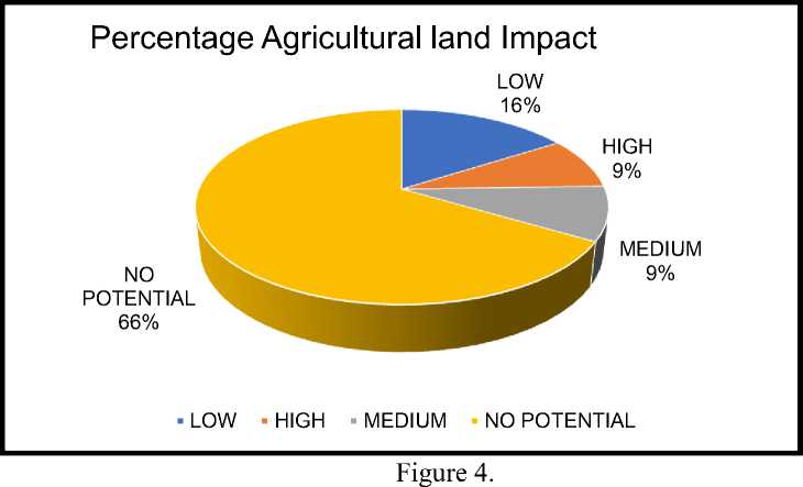
Percentage Agricultural Land Impact
Landslide potential in the research area is on agricultural land with a high potential for impact because the site's position is influenced by steep slopes spread in the upstream and middle parts of the Ayung watershed.
Landslide occurrence. Land use conditions causing landslides are related to land stability, water saturation control, and soil particle bonding strength. The land in the research results in the upstream and middle parts whose use is for forest and plantation areas does not affect landslides because forest and plantation areas are relatively more able to maintain land stability. The deep root system
maintains cohesiveness between soil particles and particles with bedrock and can regulate runoff and water absorption when it rains. Meanwhile, in the upstream and central part of the research area, where the land use is used as a mixed garden, it is relatively more able to maintain land stability because of the deep root system. However, landslides will have a high potential to occur with very steep slopes (> 45%) and on soils that are sensitive to landslides. The condition of agricultural land in the research location and the spatial distribution of potential landslides on agricultural land are presented in Figure 5.
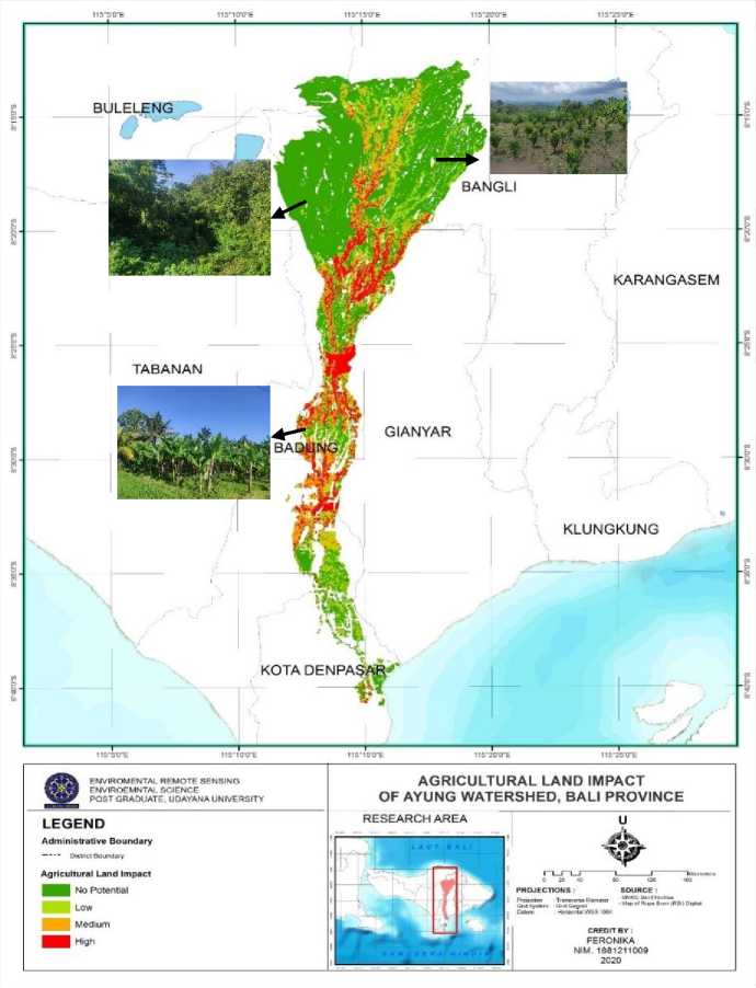
Figure 5.
Agricultural Land Impact of Ayung Watershed Bali Province
The Ayung watershed has a landslide potential area which is in the category of no potential to high potential. Classes with no potential are widespread in the upstream and downstream parts of the watershed covering an area of 18.976,90 ha (60%), the low potential category covering an area of 5.877,78 ha (19%), the medium potential category covering an area of 3.208,76 ha (10%) and the high
category which is spread in the upstream and middle part of the watershed covering an area of 3.528,55 ha (11%). The impact of potential landslides on agricultural land in the Ayung watershed is determined based on overlapping results with land use maps that have areas of no potential to high potential. The class with no potential for agricultural land is 13,268.57 Ha (66%) located in the upstream part of the watershed, the low potential is 3,268.57 Ha (16%), the medium potential is 1,782.31 Ha (9%), and the high potential
with an area of 1,707.28 ha (9%) spread over the upper and middle parts of the watershed. Land use conditions causing landslides are related to land stability, water saturation control, and soil particle bonding strength. The land in the research results in the upstream and middle parts whose use is for forest and plantation areas does not affect landslides because forest and plantation areas are relatively more able to maintain land stability.
In areas with the potential for landslides, maintenance efforts need to be made to avoid environmental damage that can trigger landslides. In landslide areas that have a high impact on agricultural land, conservation, and maintenance need to be carried out to prevent the impact of landslides on agricultural land.
REFERENCES
Althuwaynee, O. F., B. Pradhan and S.
Lee. 2012. Application of an Evidential Belief Function Model in Landslide Susceptibility Mapping. Computers & Geosciences, 44, 120135 Arsyad, S. 2012. Konservasi Tanah dan Air. Institut Pertanian Bogor Press; Bogor. Hal 53,59,114,117,129.
Arsyad, S. 2012. Konservasi Tanah dan Air. Institut Pertanian Bogor Press; Bogor. Hal 53,59,114,117,129.
Asdak, C. 2007. Hidrologi dan Pengelolaan Daerah Aliran Sungai. Yogyakarta: Gajah Mada University Press.
Ashari, A., B.A.R. Apriyeni., D. Permana., dan N.R. Safarudin. 2016. Interrelasi Spasial Bentuk lahan dengan Vegetasi pada Lereng Tenggara Vulkan Ciremai: Tinjauan
Studi Biogeomorfologi. Geomedia 14 (2): 67-76
Cook, R.U. dan Doornkamp, J.C. 1994. Geomorphology in Environmental Management – and New Introduction. Amsterdam: Elsevier
Haryana, P. 2011. Perubahan Penutupan/ Penggunaan Lahan dan Perubahan Garis Pantai di DAS Cipunagara dan sekitarnya, Jawa Barat. Institut Pertanian Bogor. Jawa Barat.
Indarto, 2010. Hidrologi Dasar Teori dan Contoh Aplikasi Model Hidrologi. Bumi Aksara; Jakarta.
Khosiah dan A. Ariani. 2017. Tingkat Kerawanan Tanah Longsor di Dusun Landungan Desa Guntur Macan Kecamatan Gunungsari Kabupaten Lombok Barat. JIME 3(1): 195-200.
Nursa’ban, M. 2008. Identifikasi Kerentanan dan Sebaran Longsor Lahan Sebagai Upaya Mitigasi Bencana di Kecamatan Bener Kabupaten Purworejo. Universitas Negeri Yogyakarta
Pradnyasari, N.M.D. 2019. “Pemetaan Potensi dan Kerawanan Longsor Lahan diDesa Belanding, Desa Songan A dan Songan B Kecamatan, Kabupaten Bangli”. (Skripsi). Tidak diterbitkan. Fakultas Pertanian. Universitas Udayana
Sukarman dan A. Dariah. 2014. Tanah Andosol di Indonesia. Balai Besar Penelitian dan Pengembangan Sumberdaya Lahan Pertanian. Bogor
Thornbury dan D. William. 1969. Principles of Geomorphology. USA: Department of Geology Indiana University.
ECOTROPHIC • 17(2): 233-243 p-ISSN:1907-5626,e-ISSN: 2503-3395
243
Discussion and feedback