BEHAVIOR OF THE CHANGJIANG DILUTED WATER IN THE EAST CHINA SEA OBSERVED WITH SATELLITE TRACKING DRIFTER
on
Ecotrophic ♦ 4 (2) : 97-100
ISSN: 1907‐5626
BEHAVIOR OF THE CHANGJIANG DILUTED WATER IN THE EAST CHINA SEA OBSERVED WITH SATELLITE TRACKING DRIFTER
Syful Anas1 I W Kasa2 I W Arthana3
-
1) PPPG Pertanian Cianjur
-
2) Jurusan Biologi FMIPA Unud
-
3) Program Magister Ilmu Lingkungan Unud
ABSTRACT
The Changjiang River is the largest river in China with an average discharge of 9x10¹¹ m3 /year . The Changjiang river supplies about 80% of total discharge of fresh water from rivers around the Yellow Sea, East China Sea and Bohai Sea. Its monthly mean transport has a large seasonal variation from 103 m3s-1 in January to 4.8x 10⁴ m3s-1 in July around an annual mean of 3 x10⁴ m3s-1 , and large inter annual variation in the annual mean from 2,2x 10³ to 3,5 x 10³ m3s-1 during the 19-year period from 1970 to 1988 (Yanagi, 1994 ). The East China Sea Current, associated with the Changjiang discharge, flows southward along the Fujian and the Zhejiang Coast of China in winter and Northeastward to the Cheju island in summer, which forms thin low salinity plume called Changjiang Diluted Water (CDW) in summer (Breadsley. et al , 1983, 1985; Hu, 1994, Guan ,1994).
CDW moves differently in season. It moves southward in winter and eastward in summer according to its salinity distribution. The relation between wind and movement of the low salinity water also has been suggested in many ways.
Generally all of drifter moved northeastward at first, then after 10 days each drifter moved to different sites. Each drifter moving though velocities is about 0.1 m/s and 0.2 m/s. Most of drifters were generally moving to northeastward to the right of the wind direction at these events. It indicates that the sudden changes of drifters trajectory are caused by abrupt changes of winds.
Temporal variation in salinity gradually increase during the drifters were in the moved eastward . The salinity rapidly increase during the typhoon passage. Before and after the salinity rapidly increase during typhoon passage, it was mostly constant or very gentle.
The vertical velocity generated by wind just after deployment drifters for ten days in drifter deployment in 2007 was about 10-5 – 10-6 ms-1. The vertical velocity during typhoon passage on August 2007 was larger than on passed the area. It is suggested that there was significant divergence in the surface layer during the typhoon passed the area ,resulting in the larger upward vertical velocity in this region.
Keywords : Changjiang Diluted Water, Movement of drifters, Temporal variation in Salinity, Vertical velocity generated by wind.
ABSTRAK
Sungai Changjiang adalah sungai terbesar di China dengan rata –rata debit air 9x10¹¹ m3 /tahun, sungai Changjiang menyuplai sebesar 80% total debit air bersih sekitar laut kuning, laut China Timur, dan laut Bohai. Debit air yang disuplai rata-rata transport memiliki variasi musiman yang besar sekitar 103 m3s-1 pada bulan Januari sampai 4.8x 10⁴ m3s-1 pada bulan Juli dengan rata –rata sebesar 3 x10⁴ m3s-1, dan besar rata –rata bulanan adalah berkisar 2,2x 10³ - 3,5 x 10³ m3s-1 dalam kurun waktu 19 tahun dari periode 1970 sampai 1988 ( Yanagi, 1994). Arus laut china timur berasosiasi dengan debit aliran sungai changjiang mengalir ke arah selatan di sekitar Fujian dan pantai Zhejiang China pada saat musim dingin dan mengalir ke arah timur laut sampai ke pulau Cheju pada saat musim panas, bentuk lapisan tipis diatasnya adalah salinitas rendah yang disebut air lemah sungai changjiang /changjiang diluted water pada saat musim panas (Breadsley. et al , 1983, 1985; Hu, 1994, Guan ,1994).
CDW bergerak berbeda dalam setiap musim. CDW bergerak ke arah selatan pada saat musim dingin dan bergerak ke arah timur pada saat musim panas berdasarkan sebaran salinitasnya. Hubungan antara angin dan pergerakan air salinitas rendah disebabkan berbagai faktor .
Secara umum, seluruh drifter bergerak ke arah timur laut pada saat awal, kemudian setelah 10 hari masing –masing drifter bergerak ke arah yang berbeda . setiap drifter bergerak dengan kecepatan sebesar 0.1 - 0.2 m/det. Semua drifter bergerak ke arah timur laut linier dengan arah angin pada saat-saat tertentu. Hal ini mengindikasikan bahwa perubahan secara tiba –tiba dari arah pergerakan drifters disebabkan oleh perubahan arah angin secara tiba-tiba.
Sebaran salinitas secara temporal naik secara gradual selama drifter bergerak ke arah timur. Salinitas naik secara signifikan selama taifun. Sebelum dan sesudah naik salinitas secara signifikan , salinitas konstan.
Kecepatan vertikal yang di bangkitkan angin untuk drifter sesudah drifter dioperasikan untuk 10 hari adalah sebesar 10-5 – 10-6 m/det. Kecepatan vertikal selama taifun pada agustus 2007 lebih besar dari kondisi biasa di daerah tersebut. Hal ini mengindikasi bahwa arus divergen pada permukaan laut selama taifun menghasilkan kecepatan vertikal yang lebih besar pada daerah ini.
variasi temporal salinitas, kecepatan vertikal yang
research are : 1. To investigate temporal variation in salinity on the Behavior CDW in the East China Sea using satellite tracking drifter , CTD data and wind data, 2. To investigate the contribution of vertical velocity generated by wind influence due to salinity increase in the CDW.
RESEARCH METHODS
Kata kunci : Changjiang Diluted water, pergerakan drifter, dibangkitkan oleh angin.
INTRODUCTION
Background
The Changjiang river is the largest river in China with an average discharge of 9x10¹¹ m3 /year . The Changjiang river supplies about 80% of total discharge of fresh water from rivers around the Yellow Sea, East China Sea and Bohai Sea. Its monthly mean transport has a large seasonal variation from 103 m3s-1 in January to 4.8x 10⁴ m3s-1 in July around an annual mean of 3 x10⁴ m3s-1 , and large interannual variation in the annual mean from 2,2x 10³ to 3,5 x 10³ m3s-1 during the 19-year period from 1970 to 1988 (Yanagi, 1994 ). The East China Sea Current, associated with the Changjiang discharge, flows southward along the Fujian and the Zhejiang Coast of China in winter and Northeastward to the Cheju island in summer, which forms thin low salinity plume called Changjiang Diluted Water (CDW) in summer (Breadsley. et al 1985).
The CDW is formed by the mixing of the Changjiang runoff with the East China Sea water, contains various terrigenous materials and has a significant effect on the marine ecosystem of the East China Sea. The Distribution of CDW shows several low salinity patches ,i.e., not a single tongue shaped pattern. Some patches show a bowl shaped distribution pattern in the vertical with a clear surface low salinity core. (Lee et al.2003, Lie et al.,2003).
CDW moves differently in season. It moves southward in winter and eastward in summer according to its salinity distribution. For the dispersion processed of CDW can be influenced by several factors, various mechanisms have been suggested such as large rivers discharge (Guan, 1994), monsoon winds ( Bang and lie, 1999), and the tidal residual current (Lee and Beardsley, 1999, Oh and Park 2004). However, monsoon wind seems to be major driving force to make the prominent seasonal difference in its movement ( Chang and Isobe. 2003; Pang et. al. 2004). The relation between wind and movement of the low salinity water also has been suggested in many
1. Location of Research
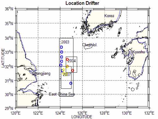
Figure1 Location of deployment drifter at East China sea in 2003, 2004 and 2007
ways.
The problem in this research are : 1. How the temporal variation in salinity on the behavior of CDW detected by drifters during typhoon passage, 2. How the contribution vertical velocity influence the salinity increase abruptly on the behavior of CDW. As the objective in this
On 8 and 9 June , eight drifters deployed by RIAM Kyushu University collaborative with Cheju National University, Korea Ocean Research and Development Institute (KORDI) and National Fisheries Research and Development Institute (NFRDI). All drifters equipped with temperature and salinity sensors were deployed every 20’ between 31000 N and 33020 N along 124000 E by Training vessel Ara of Cheju National University. Drifter cyclindrical drogue with 3 m length was located about 4 m below the surface.
At 14 , 15 , and 16 July 2004 three drifters deployed by RIAM Kyushu University, All drifters equipped without temperature and salinity sensors. Drifters deployed different time and sites.
On 8 and 9 August 2007, five drifters deployed by RIAM Kyushu university and two drifters deployed by National Fisheries Research Development Institute
(NFRDI) Korea. Five drifters deployed between 310 N and 330 along 1240E, and two drifters deployed northern part from five drifters.
Drifter data used in this thesis were obtained through the collaboration research between RIAM Kyushu University and Cheju National university , Korea Ocean Research and Development Institute (KORDI) and National Fisheries Research and Development Institute (NFRDI) Korea , in 2003 , 2004 and 2007.
In this study, to investigate the behavior of the Changjiang diluted water , daily wind stress is derived from the Quikscat level-3 surface wind velocity dataset. The Quikscat orbit is such that ascending and descending equator crossing are at local times of 6 a.m and 6 p.m, respectively.
Temporal variations of salinity estimated from temperatur and salinity sensors data from drifter data. From this data we know temporal and temporal variation of salinity in the Changjiang Diluted water along drifter track .
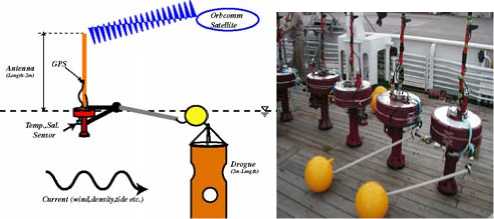
Figure 2. Satellite Tracking drifters
(courtesy by Ocean Circulation Dynamic laboratory RIAM Kyushu University)
RESULT AND DISCUSSION
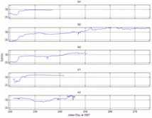
Generally all of drifter moved northeastward at first, then after 10 days each drifter moved to different sites. Each drifter moving though velocities is about 0.1 m/s and 0.2 m/s. Stick –diagram figure shows and represent velocities and direction of drifter movement just after 25 hour after deployment.
Generally, temporal salinity gradually increase during the drifters were in the moved eastward . The salinity rapidly increase in the 223 and 224, when the typhoon passage in this area. Before and after the salinity rapidly increase at 223 and 224, it was mostly constant or very gentle.
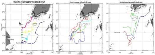
Figure 3. Trajectory of Drifters deployed in 2003 , 2004 and 2007
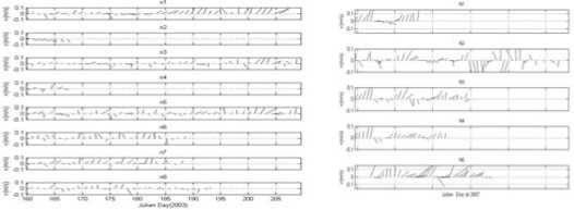
Figure 4 Stick –diagram drifter velocity during drifter deployment at 2003 and
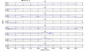
Figure 5. Temporal variation in salinity during deployment drifter 2003 and 2007
-
3. Vertical velocity generated by wind influence the salinity increase
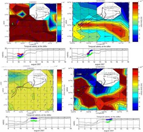
Figure 6. spatial variation vertical velocity from quikscat data and temporal variation in salinity detected by drifter deployed at 2007
During the typhoon passage on 11 and 12 August 2007, the vertical velocity larger than before and after typhoon passage, corresponding that the vertical velocity
could contribute to the increase in salinity. That means, vertical velocity into the CDW would supply high salinity water in the lower layer to the surface layer.
Considering the information on the vertical velocity, it is concluded that the salinity in the CDW increase would be caused by salt supplied from the lower layer.
CONCLUSSION AND SUGGESTION
From the above results and discussion, the author make some conclussion, as follows:
-
1. The drifters generally moved to the direction of Ekman drift in 2003 and 2007 while relatively strong southward movements were shown in 2004.
-
2. The vertical velocity generated by wind has significant factor influence the salinity increase rapidly during typhoon passage, and before and after the typhoon passage the salinity increase mostly constant or very gentle.
-
3. The salinity in the CDW increase would be caused by salt supplied from the lower layer.. its suggest that the vertical velocity could supply the high salinity in the lower layer to the surface layer.
-
1. It is needed to carry out further research of the relationship between wind and direction of movement low salinity by using numerical simulation.
-
2. it is important to know more details about seasonal variation on the the behavior of the Changjiang Diluted Water specially about contribution of vertical process influence the salinity increase.
ACKNOWLEDGEMENT
Writer would like to acknowledge the important contribution and guidance Prof. Takeshi Matsuno , and all members in Ocean Dynamic Laboratory, RIAM Kyushu University ,Japan for their helps and guidance during this research .also to National Fisheries Research and Developmeny Institute (NFRDI) ,Korea and Korea Ocear Research Development Institute (KORDI), korea for their data for complete this research. Writer also wishes to express his sincere gratitude to first supervisor, Prof. Dr. Yasuhiro Sugimori (Director of Remote Sensing and Ocean Science/CReSOS), Udayana University and Prof. Dr. Ir. I Wayan Kasa, M.Rur., Sc as second supervisor for valuable suggestion and guidance during the research written.
REFERENCES
Bang , I.-K. and H.-J. lie, 1999. A Numerical Experiment on The Dispersion of the Changjiang River Plume. Journal Of the Korean Society in Oceanography 34, 185 -199.
Beardsley, R. C., R. Limeburner, H.Yu and G.A. Cannon, 1985. Discharge of the Changjiang (Yangtze River) Into the East China Sea. Continental Shelf research 4(1-2), 57 – 76.
Chang,P.H. and A.Isobe, 2003. A Numerical study on the Changjiang Diluted water in The Yellow and East China Seas . Journal of geophysical Research 108 (C9), 3299, doi:10.1029/2002JC001749.2003.
Chen, C.T.A.,Wang, S.L , 2006. A salinity front in the southern East China Sea separating the Chinese Coastal and Taiwan Strait waters from Kuroshio waters. Continental Shelf Research (26) pp.1636 – 1653.
Guan, B., 1994. Pattern and structures of the currents in Bohai, Huanghai and East China Seas. In: zhou D.,Y.-B. Liang and C.—K. Zeng, (Eds), Oceanology of China Sea, vol.1, Kluwar Academic Publisher, London, pp.17 – 26.
Hsueh, Y., Lie, H.J., Ichikawa, H., 1996. On Branching of the Kuroshio West of Kyushu. Journal of Geophysical Research 101, 3851 -3857.
Ichikawa, H., and Beardsley, R. C, 2002. The Current system in The Yellow and East China Seas. Journal Of Oceanography vol.58, pp. 77 – 92
Lee, S.H., R.C..Beardsley, 1999. Influence of on residual tidal currents in the Yellow Sea, Journal of Geophysical Research 104(C7), 15679 – 15701.
Lie, H.-J., S.Lee, and C.-H. Cho, 2002. Computation methods of major tidal currents from satellite tracked drifters position, with application to the Yellow and East China Seas. Journal Geophysic Research 107 (C1), 10. 1029/2001JC000898.
Lie, H.J., Cho,C.H., 2002. Recent advantes in understanding the circulation and hydrography of the East China Sea. Fisheries Oceanography 11(6), pp. 318 -327.
Matsuno, T, Lee. J.S, Shimizu, M., Kim,S.H, and Pang,I.C, 2006. Measurement of Turbulent energy dissipation rate E and an evaluation of dispersion process of the Changjiang Diluted Water in the East China Sea. Journal of Geophysical Research 111(C11S09), doi : 10.1029/2005JC003196, 2006
Matsuno, T., Kanari, S., Kobayashi, C., and Hibiya, T., 1994. Vertical Mixing in the Bottom Mixed Layer near the Continental Shelf Break in The East China Sea. Journal of Oceanography vol.50,pp. 437 – 448, 1994.
Nitani, H., 1972. Beginning of the Kuroshio. In : Stommel,H.,Yoshida,K.(Eds.), Kuroshio, its Physical Aspects. University of Tokyo Press, Tokyo, pp. 129 -163.
Pan, Y.Q., Su, J.L.,Xu, D.R., 1987. Oceanographic condition of Taiwan warm Current area during June – July, 1984. In: Sun, X.P.(Ed.), Essay on the investigation of kuroshio Currents. Ocean Press, Beijing, pp. 118 -132.
Su, J.-L.,Pan, Y.-Q.,Liang,X.S., 1994. In: Zhou Di, Liang, Yuan-Bo, Zeng,C.K.(Eds), Kuroshio Intrussion and Taiwan Warm Current, in Oceanology of China Seas. Kluwer Academic Publishers, pp.59 – 70.
Wang, Y.H., Bohlen, W.F., O Donnel, J., 2000. The Taiwan –Tsushima warm current system: its path and the transformation of the water masses in the East china Sea. Journal of oceanography 56, 311 – 317.
Yanagi,T., Shimizu,T.,Lie,H.J., 1998. Detailed structure of the Kuroshio frontal eddy along the shelf edge of the East China Sea. Continental Shelf Research 18, 1039 -1056.
Yanagi,T., 1999. Coastal Oceanography. Terra Scientific Pub. Co., Tokyo, 162pp.
100
Discussion and feedback