STUDY OF CORAL REEF DISTRIBUTION AROUND BADUNG STRAIT USING ALOS SATELLITE DATA
on
Ecotrophic ♦ 3 (2) : 87-91
ISSN: 1907-5626
STUDY OF CORAL REEF DISTRIBUTION AROUND BADUNG STRAIT USING ALOS SATELLITE DATA
Suciati1) and I Wayan Arthana2)
-
1) Sekolah Menengah Kejuruan Negeri 3 Tegal
-
2) Master Program of Environment Science Postgraduate Program Udayana University Email: pmil-unud@indo.net.id
ABSTRACT
Coral reef ecosystem has become a centre of interest because of the development of marine tourism development, coral fragment trade, and other activities that are able to destroy coral reef ecosystem. ALOS with AVNIR-2 sensor was selected because it has 3 visible spectrums which have the ability of penetration into water column, also it have high enough of spatial resolution i.e.10 meters.
The aims of this research are: 1) to identify the level of accuracy of ALOS satellite image in activity for coral reef distribution mapping and 2) to identify the general condition of coral reefs in around Badung Strait.
Preliminary processes of image processing are geometric correction and atmosphere correction. Water column effect was reduced by Lyzenga Algorithm. Five classes were determined by multispectral classification process e.i. coral, vegetation, sand, rubble of coral and substrate. Ground check was done to identify the accuracy level. The method accuracy by Lillesand and Kiefer was used in this research.
The result of accuracy test shows that classification accuracy was 87.16% for overall accuracy. Results of image interpretation show that live coral in around Badung strait is estimated to have about 141,056 hectares width. It was covering Denpasar Regency in the east and south-east side of Serangan Island with the fringing reef type; Klungkung Regency in the west side of Lembongan Island with the fringing reef type and in the south side with the platform type, while in Gianyar Regency was not found the coral reef distribution.
Key word: Coral reef distribution, ALOS satellite image
ABSTRAK
Ekosistem terumbu karang mulai menarik perhatian karena adanya perkembangan wisata bahari, perdagangan batu karang, dan beberapa aktivitas manusia yang dapat merusak ekosistem terumbu karang. Penggunaan ALOS dengan sensor AVNIR-2 dalam penelitian ini karena mempunyai 3 spectrum tampak (biru, hijau, merah) yang mampu berpenetrasi ke dalam kolom air, juga mempunyai resolusi spasial yang cukup tinggi yaitu 10 meter.
Tujuan penelitian ini adalah: 1) untuk mengetahui tingkat ketelitian citra satelit ALOS untuk pemetaan sebaran terumbu karang dan 2) untuk mengetahui sebaran terumbu karang secara umum di sekitar Selat Badung.
Tahap awal pengolahan citra adalah koreksi geometrik dan koreksi atmosfir. Pengaruh kolom air direduksi dengan algoritma Lyzenga. Lima kelas ditentukan dengan proses klasifikasi multispektral yaitu: karang, vegetasi, pasir, pecahan karang dan substrat. Ground checks dilakukan untuk mengetahui tingkat ketelitian interpretasi citra. Metode Lillesand dan Kiefer untuk uji ketelitian hasil interpretasi. Hasil uji menunjukkan tingkat ketelitian keseluruhan klasifikasi penelitian ini adalah 87,16%. Hasil interpretasi citra menunjukkan luas terumbu karang di sekitar Selat Badung diperkirakan sekitar 141,056 hectare. Sebarannya mencakup Kota Denpasar yaitu di bagian timur dan tenggara Pulau Serangan dengan tipe terumbu karang tepi dan sepanjang Pantai Mertasari sampai Pantai Matahari Terbit dengan tipe terumbu karang penghalang; Kabupaten Klungkung yaitu di bagian barat Pulau Lembongan dengan tipe terumbu karang tepi dan di bagian selatannya dengan tipe terumbu karang takat, sedangkan di Kabupaten Klungkung tidak ditemukan sebaran terumbu karang.
Kata kunci: Sebaran terumbu karang, citra satelit ALOS
INTRODUCTION
Indonesia has the coastal line about 81,000 km and the width is about 3,1 million km2, including the right and obligation for exploiting and managing the exclusive economic one agree with ratification of United Nations Convention on the Law of the Sea 1982. This condition makes Indonesia have the largest marine biodiversity in the world. One of the potential marine resources is coral reef.
Indonesia has 14 % of all the coral reef in the world and it covers an area of about 50,000 km2 (Priyono, 2007).
In the past few years, coral reef ecosystem has become a centre of attention because of the marine tourism development, coral fragment trade, and other activities that are able to destroy coral reef ecosystem, including coral reef around Badung Strait, Bali. Uncontrolled human activities cause decreasing the quality of coastal water around Badung Strait. Therefore, in order to avoid further
exploitation damage, the better coral reef ecosystem management is urgently needed. Remote sensing can be used as a management tool for mapping and monitoring coral reef on the earth widely (Holden, et.al., 2000; Sudiarta, 2000)
ALOS Satellite with sensor AVNIR-2 has 3 visible spectrums i.e. band 1(blue), band 2 (green) and band 3 (red) which have the ability of penetration into water column, also it has a near infra red (band 4) which has the ability of differentiate object (JAXA, 2005, 2008). Utilization of ALOS with AVNIR-2 that having 10 meters resolution is expected to give more accurate data of coral reef distribution in around Badung Strait.
The problem in this research are 1) How is the level of accuracy of satellite image of ALOS in effort of mapping distribution of coral reefs? and 2) How is the general condition of coral reefs around Badung Strait? As for this research targets are 1) To identify the level of accuracy of ALOS satellite image in activity for coral reef distribution mapping, and 2) To identify the general of coral reef distribution around Badung Strait
RESEARCH METHOD
Research area will be located in coastal around Badung Strait with the specific location at 8034’31,3”S / 115023’1,87”E - 8045’24,19”S / 115013’49”E (Gianyar until Denpasar) and 8039’28,25”S / 115027’10,46”E -8042’53,47”S / 115026’26,16”E (Lembongan Island-
Klungkung) (Figure1)
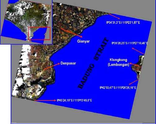
Figure 1. Research Locations in Badung Strait (Source: JAXA, 2005)
This research will be carried out for 4 months (March– June, 2008). The ALOS image which used is the recorded result of November 28th, 2006, with identity scene of ALAV2A044933770 in 1B2R level. The AVNIR-2 sensor on ALOS satellite has 4 bands consisted of 3 visible spectral and a near infra red (Table 1) The research procedure was grouped into 4 (four) steps are as follows: 1) Data collection; 2) Image Processing consisted of: (a)
preliminary step of image processing such as image cropping, geometric correction, atmosphere correction and image masking; (b) Lyzenga method application (1981), with the equation: Y=ln bi – {(ki/kj) * ln bj}; (c) Multispectral Classification; 3) Ground check; and 4)Accuracy test of image interpretation result by the method of Lillesand and Kiefer (1990)
Table 1. Sensor Description of ALOS satellite with
AVNIR-2 Sensor
|
No. Band |
Wavelength |
Band Position |
|
1 |
0.42 - 0.50 |
Blue |
|
2 |
0.52 - 0.60 |
Green |
|
3 |
0.61 - 0.69 |
Red |
|
5 |
0.76 - 0.89 |
Near Infra Red |
(Source: JAXA, 2005)
RESULT AND DISCUSSION
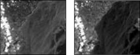
Figure 2 show that band 1 (blue) had highest contrast level, because band 1 had the highest average spectral and then followed by band 2, 3 and 4. Contrast level of object correlated with the spectral value of image. Image with higher spectral value will be brighter (Belward, 1991 in Nuarsa, 1998).
(a) (b)
(c) (d)
Figure 2. Bands of ALOS before Image Processing (a) band 1, (b) band 2, (c) band3 and (d) band 4(Source: Analysis Result, 2008)
Rayleigh scatter as the prime cause of thin fog of image will have a stronger effect on band with the shorter wavelength (Lillesand and Kiefer, 1990). Since band 4 had the highest wavelength, band 4 was more free from the atmosphere effect and clearer than other bands (Sabin, 1986). Therefore, in this case band 4 was the most suitable one to differentiate land and water, and also as base of image masking process. Coral reef is an under water object so that bands which are able to penetrate water column is
required to observe it. Visible spectrum of ALOS with AVNIR-2 sensor, i.e. blue (band 1), green (band 2) and red (band 3), were bands that being able to penetrate into water column. Band with shorter wavelength have better ability to penetrate water column (Nybakken, 1988). Based on the ability to penetrate water column, band 1, 2 and 3 were very suitable to study benthic object like coral reef.
The Preliminary step of image processing was used to improve the image quality before the next processes. The Lyzenga Method application was used to reduce the water column effect. This process was producing 3 new images which must be overlaid to make a new image. The application of Lyzenga method will improve ability of image in recognizing different under water objects. Quantitatively, the difference between original image and Lyzenga image can be seen in calculation of variation coefficient (Std.Dev/Mean) between sand object in the different depth which used in training site for calculating of Attenuation Coefficient Ratio (Ki/Kj).
Table 2 shows that variation coefficient of sand object in Lyzenga image is decreasing. The decrease value of variation coefficient of sand object in Lyzenga image indicated that the effect of water column/ depth had decreased. The decrease of water column effect would lead to a reduction in difference of value range between coral reef in 2 meters depth and that in 5 meters depth, so that multispectral classification process using original image could not differentiate characteristics of benthic object maximally (Lyzenga, 1981). However, the existence of value range in image of Lyzenga application indicated that water column effect had not been completely eliminated.
Table 2. Variation Coefficient of Sand Object in Different Depth
|
Original Image |
Lyzenga Application Image | ||||
|
B1 |
B2 |
B3 |
B1B2 Combination |
B1B3 Combination |
B2B3 Combination |
|
0.7339946 9 |
0.8068826 6 |
0.778934 18 |
0.10630420 |
0.10292235 |
0.02123183 |
(Source: Analysis Result, 2008)
Multispectral classification by maximum likelihood method were obtain 5 spectral classes of benthic objects, e.i. coral, vegetation, sand, rubble of coral and substrate (Figure3). The result of classification accuracy was 87.16% for overall accuracy. This accuracy value is higher than the required value for image interpretation. Accuracy level for coral reef ecosystem mapping using interpretation of satellite image is acceptable if the value is not less than 75% (Mumby et.al. 2003).
Errors in classification of coral reef study usually caused by 1) Spatial factor caused pixels position to coral reef so various that it will results in difference in number of coral reef classes which could be classified and 2)
Spectral factor caused by the existence of same reflection value in different class, causing error classification.
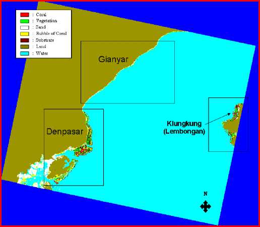
Figure 3. The Result of Multispectral Classification (Source: Analysis result, 2008)
The existence of overlaps of classes was probably caused by some factors, i.e: (a) the carry over effect of water column effect; (b) the carry over effect of atmospheric disturbance (c) horizontally, water quality was not homogeneous. The existence of water column effect was resulted from different spectral response of an object in different deepness. For example, sand spectral in 2 meters deepness did not similar to that in 20 meters deepness; and in practice the existence of sand in 20 meters deepness had the same spectral response as that of the vegetation in 3 meters deepness (Edward el al., 1999).
Influence of Indonesian Ocean in water area of south-east Bali could be seen from the steepness of the coast, including the research area. Steep coast also occurs along the Sanur Beach, where a 50-meter isobath line occur only less than 4.8 km from the coastal line, even there is a 50-meter isobath line occurs only a few meters from coastline. However, in general, this condition is relatively still safe for tourism activity (Dinas Lingkungan Hidup Kota Denpasar, 2006, 2007).
The water area around Lembongan Island has a slope that is relatively slighter than that of other water around Nusa Penida Islands. The slope of water in west side of Lembongan Island is the slightest; with slope level of 1.8% - 4.3% occurs until 200 meters level of deepness.
Results of image interpretation show that live coral (>50% live coral) in around Badung strait is estimated to have about 141,056 hectares width. Figure 3.2 shows the coral reef distribution in this research area covering
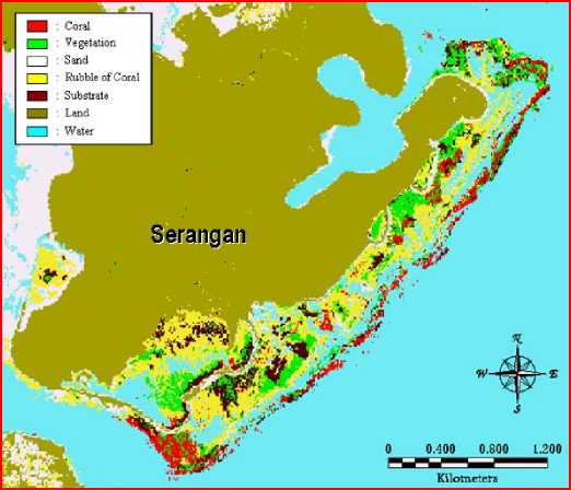
Figure 4. Coral Reef Distribution in Serangan Island (Source: Analysis Result, 2008)
Denpasar Regency (east and south-east side of Serangan Island, Mertasari Beach until Matahari Terbit Beach) and Klungkung regency (West and south side of Lembongan Island).
The data shows that there are no coral reef distributions in the area of Gianyar Regency. The type of coral reef in Serangan island is of a fringing reef type with flat and slope contour in the east side and south-east side, and almost all are covered by sand in the west side (Figure 4). Type of coral reef along Mertasari Beach until Matahari Terbit Beach is barrier reef formation with wide enough steep area. Whilst, between the barrier reef area and theland area there is shallow laguna with the field of water vegetation (sea grass and seaweed) which almost covers all of area (Figure 5). The outer side of Laguna is precipice of coral. Its growth is good in the 10 meters depth until 20 meters depth of isodepth line. The west side of coastal area of Lembongan Island tends to slope, so that type of coral reef in this location is fringing reef type. Whilst, the south side of this island is slightly steeper than that in the west side and the type reef in this side is so called platform reef type (Figure 6). This existing condition is confirmed the results of research carried out by Bapedalda Propinsi Bali and Puslit Universitas Warmadewa (2002), Sudiarta (2006), Prasetia (2007) and Dinas Lingkungan Hidup Pemerintah Kota Denpasar (2006, 2007).
Generally, coral reef distribution shows a distribution pattern matching with geomorphologic zoning of location where coral reefs live, grow and expand. This occurs because coral reef is a result of interaction between coral reef formations process and physical characteristics of sea water (Mumby, et.al., 2003).
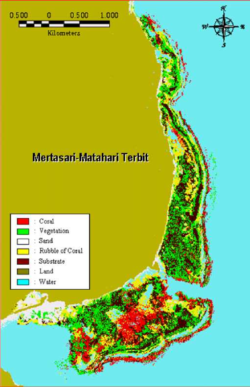
Figure 5. Coral Reef Distribution in Mertasari Beach-Matahari Terbit Beach (Source: Analysis Result, 2008)
Basically, remote sensing technique for coral reef mapping is applying the precise method to stick out the sea bottom appearance which was recorded in the form of image and its smallest width is 1 pixel. ALOS satellite with AVNIR-2 sensor has spatial resolution 10 meters. It is depicting the wide of area 100 m2 (10 meters x 10 meters) of each pixel. In once recording, this satellite able to cover 4900 km2 area width (70kmx70km).
Generally, the area of coral reef has the high biodiversity. Coral reef ecosystem has habitats with high variation, but oftentimes, each habitats taking the narrow area.. This condition will give the influence to result of satellite recording. Every object gives different reflectance value to the result of satellite recording. The difficulty of this condition is if there is more than 1 object in 1 pixel and they have the different abundance, so the reflectance value in a pixel was not the true depiction of object. This condition will influence to the result of accuracy level. Besides that, when to go to the sensor, the
signal of electromagnetic wave which has the interaction with coral reef as under water object have to through 2 medium i.e. atmosphere and water column. The condition differs with land object which is only through the medium of atmosphere. Different of depth also will be influencing to the result of satellite recording to reflectance value of coral reef. If there is the increase of deepness, so it will be lessening the ability of sensor to differentiate the same object which was recorded by different channel.
However, the use of ALOS satellite as tool for mapping of coral reef distribution will be able to improve the accuracy of result, because it has the spatial resolution 10 meters. Heterogeneities level of object which is influencing the value of each pixel would be minimize and automatically it will be improve the homogeneous of object, because the pixel width is small. This condition could be seen from the amount of object which could be classified in this research.
The other thing which must be paid attention in coral reef mapping using satellite is un-complete recording to the coral reef in the form of wall. Usually, the coral reef in the wall form is the Barrier reef type, because the form of satellite recording is the recording of width horizontally or the recording of parallel with the earth surface. The objects which have incline position could not recorded for all of area, so that it could be make the different of the object width which was identified.
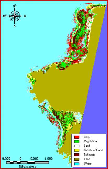
Figure 6. Coral Reef Distribution in Lembongan Island (Source: Analysis Result, 2008)
CONCLUSION AND SUGGESTION
The research conclusions are: 1) The level of classification accuracy was 87.16% for overall accuracy. This value is higher than the required value for image interpretation. Accuracy level for coral reef ecosystem mapping using interpretation of satellite image is acceptable if the value is not less than 75%. It shows ALOS satellite Image with AVNIR-2 sensor is good enough and up to standard as the data source in effort of coral reef distribution mapping around Badung Strait. The result of classification in this research could be differentiating benthic object into 5 classes are: coral, vegetation, sand, rubble of coral and substrate; 2) Results of image interpretation show that the distribution of coral reef in around Badung strait is estimated to have about 141.056 hectares width (14.105 pixels). The coral reef distribution covering Denpasar Regency (east and southeast side of Serangan Island, Mertasari Beach, Semawang Beach until Shindu Beach and Shindu Beach until Matahari Terbit Beach) and Klungkung regency (West and south-east side of Lembongan Island). There is no coral reef distribution in the area of Gianyar Regency. Type of coral reef along Mertasari Beach until Matahari Terbit Beach forms Barrier reef formation; The coral reef in Serangan island and west side of Lembongan Island is fringing reef type; While, in the south side of Lembongan island is platform reef type.
Base on the result of this research, the author’s suggestion are: 1) The existence of overlaps of classes was probably caused by some factors, i.e: (a) the carry over effect of water column effect; (b) the carry over effect of atmospheric disturbance (c) horizontally, water quality was not homogeneous. Therefore, it requires a better atmosphere correction method and water column correction method, so that it can be known the most precise method for processing of ALOS satellite image as mapping tool of coral reef distribution; 2) It is necessary to carry out the further research. For example is using newest image, to compare its level accuracy. Also to know the growth and the change of coral reef distribution; 3) besides by survey of the field (ground check), also it requires approximation of multi-image e.i: air photograph or other high resolution image to confirm the result of multispectral classification.
Acknowledgements. First of all I thank to The Almighty ALLAH SWT for His Greatfull, Kindness, and Blessing on me in finishing the research report. With the all off humbleness, I am most grateful to my first supervisor Prof. Dr. Yasuhiro Sugimori from Center of Remote Sensing and Oceanography, for his timely supervision, guiding me in the planning, supporting and excusing in my study, and to my second supervisor Dr. Ir. I Wayan Arthana, MS also as The Head of Post Graduate Program of Environmental Science, Udayana University for all of his comments, suggestion, support and advise.
REFERENCES
Badan Pengendalian Dampak Lingkungan Daerah Propinsi Bali and Pusat Penelitian Universitas Warmadewa. 2002. Terumbu Karang Di Bali. Denpasar: Bapedalda Propinsi Bali and Puslit Universitas Warmadewa.
Dinas Lingkungan Hidup Kota Denpasar. 2006. Laporan Kegiatan Monitoring Terumbu Karang. Denpasar: Dinas Lingkungan Hidup Kota Denpasar.
Dinas Lingkungan Hidup Kota Denpasar. 2007. Laporan Kegiatan Monitoring Terumbu Karang: Pada Kegiatan Pengelolaan dan Rehabilitasi Terumbu Karang, Mangrove, Padang Lamun, Estuari dan Teluk. Denpasar: Dinas Lingkungan Hidup Kota Denpasar.
Edwards, A.J., P. J. Mumby, E.P. Green and C.D. Clark. 1999. Application of Satellite and Airborne Image Data to Coastal Management. Seventh Computer_Based Learning Module (Bilko for Windows). UNESCO
Holden, H., C. Derksen and E. LeDrew. 2000. Coral reef ecosystem change detection based on spatial Autocorrelation of multispectral satellite data. Singapore: Department of Geography, National University of Singapore. Available from: http://www.gisdevelopment.net/aars/acrs/ 2000/ts3/cost006pf.htm.
Japan Aerospace Exploration Agency (JAXA). 2005. Simulated ALOS PRISM Standard Digital Surface Model Products. Japan: JAXA EORC.
Japan Aerospace Exploration Agency (JAXA). 2008. ALOS Research Announcement -Main Body Earth. Observation Research Center, Japan: JAXA EORC. Available from:
http://www.eorc.jaxa.jp/ALOS/ra/ra1_body.htm
Lillesand, T.M. and R.W. Kiefer. 1990. Penginderaan Jauh dan Interpretasi Citra. (Dulbahri, Prapto Suharsono, Hartono, Suharyadi, Pentj). Yogyakarta: Gadjah Mada University Press.
Lyzenga, D. R. 1981. Remote Sensing of Bottom Reflectance and Water Attenuation Parameters in Shallow Water Using Aircraft and Landsat Data. International Journal of Remote Sensing, Vol. 2, No 1, 71-82.
Mumby, PJ., W. Skirving, A.E. Strong, J.T. Hardy, E. LeDrew, E.J. Hochberg, R.P. Stumpf and L.T. David. 2003. Remote Sensing of Coral Reefs and Their Physical Environment. Marine Pollution Bulletin, 2003 edition. Available from: www.sciencedirect.com.
Nuarsa, I.W., 1998. “Penggunaan Analisis Citra Digital dan Sistem Informasi Geografi untuk Prediksi Besarnya Erosi di DAS Ayung Bagian Hilir Kabupaten Badung Propinsi Bali”(thesis). Jogjakarta: Universitas Gadjah Mada.
Nybakken, J.W. 1988. Biologi Laut Suatu Pendekatan Ekologis. Jakarta: PT. Gramedia Pustaka Utama.
Prasetia, I. N. Y. 2007. “Study of Coral Recruitment in Nusa Lembongan Island, Nusa Penida, Klungkung, Bali” (thesis). Denpasar: Udayana University.
Priyono, J. 2007. Pemetaan Terumbu Karang dengan Satelit Sumberdaya Alam. Sutikno Org. Edition of Monday, 24 September 2007. Available from: http://www.sutikno.org /index.php?option=com_ content&task=view&id=48& Itemid=47
Sabin, F.F. 1986. Remote Sensing Principles and Interpretation. Second Edition. New York: W. H. Freeman and Company.
Sudiarta, I.G. 2000. Permasalahan Lingkungan di Wilayah Pesisir dan Laut di Bali Bagian Tenggara serta Program Pengelolaan Wilayah Pesisir Terpadu. Makalah Workshop Intergrated Coastal Management (ICM). Denpasar, 29 Desembr 2000.
Sudiarta, I.G. 2006. “Analisis Citra Satelit Aster untuk Pemetaan Sebaran dan Status Terumbu Karang di Kepulauan Nusa Penida” (tesis). Denpasar: Udayana University.
97
Discussion and feedback