North Natuna Waters Dispute Resolution
on

Vol. 45 No. 1, April 2023
https://ojs.unud.ac.id/index.php/kerthapatrika
E-ISSN 2579 9487
P-ISSN 0215 899X
North Natuna Waters Dispute Resolution
Suwinto Johan1, Ida Kurnia2
1Fakultas Bisnis Universitas Presiden, E-mail: suwintojohan@gmail.com
2 Fakultas Hukum Universitas Tarumanagara, E-mail: idah@fh.untar.ac.id
Article Information
Enter : 25 September 2022 Accepted : 07 April 2023
Rise : 30 April 2023
Keywords :
Conflict, International Law;
North Natuna
Abstract
This study seeks to discuss the most effective ways to resolve conflicts in the North Natuna Sea. China has repeatedly violated the North Natuna waters. The Indonesian government has carried out security in the North Natuna waters. This dispute resolution has not found the best way for Indonesia or China. Indonesia claims North Natuna waters governed by the Law of the Sea Convention of the United Nations (UNCLOS 1982) while China claims North Natuna waters unilaterally based on the nine-dash line. The Natuna dispute has become a national issue in Indonesia. A normative legal methodology is employed in this study. The research discussion does not only focus on disputes but also on the relationship with the environment. This study concludes that the sea is a very important source of biological life. Every country has an interest in marine waters. Biological resources in the sea are always moving and sometimes their rights and authority are transferred to other countries. Biological marine resources have an ecosystem of living life. The Indonesian government must take a prudent stance on the dispute over the North Natuna waters with the Chinese government. North Natuna waters have strategic value for many countries, not only Indonesia.
Violations of the Natuna waters have occurred repeatedly. This violation was committed by the Chinese Coast Guard and Chinese fishing vessels.1 This violation includes fishing theft, disrupts the oil drilling process in Natuna, and collects data on the condition of Natuna waters resources.
Dispute resolution is not easy to resolve. This dispute has no advantage if brought before the International Court of Justice (ICJ) or the Permanent Court of Arbitration (PCA).2 The United Nations Convention of the Law of the Sea (UNCLOS) 1982 has been ratified by the governments of China and Indonesia.
The Natuna dispute will never be resolved because the two countries do not recognize each other's claims.3 Indonesia claims the Natuna Sea under the Exclusive Economic Zone (EEZ) based on UNCLOS 1982 (in the official Indonesian translation: United Nations Convention on the Law of the Sea 1982). China claims that it is entitled to natural resources in Natuna based on its version of the nine-dash line.4
This study is unique or state-of-the-art in that it covers the background history and offers answers to problems involving the South China Sea or North Natuna Sea. It is anticipated that this research will offer alternate suggestions to decision-makers and serve as inspiration for future academic study. Legally speaking, the research will aid in economic development, notably in the region surrounding the North Natuna Sea.
The Indonesian and Chinese governments agree that there is no territorial dispute in Natuna. Good relations between China and Indonesia ease the conflict over the EEZ dispute in Natuna waters because the two countries avoid regional security tensions.5 Indonesia is interested in regional stability and good bilateral relations with China, so the diplomatic alternative is an option. China needs Indonesia to build a good connection with other countries in Southeast Asia.
This research discusses the dispute resolution of the North Natuna waters in terms of its legal aspects without compromising the overall geopolitical interests, considering that every legal product cannot be separated from its political aspects, especially in the international community, where the political part is more regulated than the legal aspect. Therefore, this research pays attention to environmental factors. In previous studies that have been conducted by previous researchers, the problem of Natuna waters has been studied. Still, it is different from the research that will be presented in this paper. In existing studies, the focus is on the rights of each country to the North Natuna waters. However, in this paper, the legal aspects and the international community's interests are prioritized sustainably.
The Natuna waters have a strategic position for Indonesia.6 Natuna waters support sustainable fishing activities. This can be realized if advances in modern science and technology support it because science and technology have led humans to live a life that
is easier and faster than expected. The progress of science and technology has helped reach previously inaccessible waters and exploit the natural resources contained within, which can only be dreamed of by people in the past. Humans have reached the bottom of the deep sea and the seabed below. In the next few years, they will possibly occupy the high seas as a home and carry out other activities to support their lives. Lack of housing can be overcome by reclamation. Water shortages can be overcome by the distillation of seawater with chemical processes.
The point is that life will be more "overcome." The question is whether everything has no limit. The progress of human science and technology is trying to uncover the secrets of this nature. Nevertheless, every time this secret is unraveled, some mysteries need answers. On the other hand, the progress that has been made has given birth to a form of life in which humans have a myth that the human mind can solve all problems of life, so it is necessary to understand that everything has its limitations, including biological resources, such as fish, which can regenerate and be "renewable." This means that without paying attention to all of this, the consequences are damage to nature. Humans are subject to nature and must adapt to nature. It can be said that humans have begun to explore nature, using nature to fulfill their life interests. As a result, the use of natural resources that exceed the limit will damage nature itself. The imbalance in the use of natural resources will have its consequences. Therefore, it is necessary to pay attention to the balance in the use of natural resources. Humans are destined to take advantage of nature but still maintain the balance of nature and prevent its effects from affecting humans themselves.
The conditions described above occur in Natuna waters. Marine life can be supported by the natural resources available in the waters around the Natuna Islands.7 The dispute between the two countries, between Indonesia and China, tends to resolve this issue bilaterally without involving other parties, and the Indonesian government will remain with the current conditions as long as Beijing does not take aggressive action. However, how long this can last is still unclear.8 This condition certainly has an impact on the natural resources contained in it.
The Indonesian government's diplomacy policy is still not optimal due to the lack of coordination between relevant agencies in implementing Indonesia's maritime defense diplomacy policy,9 including policies related to environmental conservation. As an effort by the Indonesian government, the government has used various methods to defend the North Natuna waters. The Indonesian government has used international instruments, bilateral instruments, laws and regulations, and technical approaches based on the Manual on Technical Aspects of UNCLOS 1982.10 On the other hand, China's claims to
the North Natuna waters have no basis, where China uses the nine-dash line11, which contradicts UNCLOS 1982.
This study aims to discuss the best settlement of disputes in North Natuna waters. This dispute resolution has not found the best way for Indonesia or China. The research will be viewed from several point of views including the environmental issue. Based on the research introduction, the research problems are as follows:
-
1. How did Natuna become the territory of Indonesia?
-
2. What is the basis of China's claim to Natuna?
-
3. What are the alternatives to resolve disputes over the North Natuna waters?
-
4. Why has the Indonesian government not been able to resolve the dispute over the North Natuna waters?
-
5. What is the best solution for the dispute over the North Natuna waters between Indonesia and China?
-
2. Research Method
The research methodology adopted is the normative juridical research methodology, which is based on the aforementioned research issues. The relevant literature is reviewed in normative juridical research. Study on legal principles and norms, legal systematics, and the degree of horizontal and vertical synchronization between laws and regulations are all included in normative legal research.12 This study employs a statute approach in normative law and examines all pertinent statutes and rules. The research conducts regulatory analysis, identifies, and adapts to linked rules using the normative method. Primary, secondary, and various supplementary legal materials make up the normative juridical research materials.13 The Republic of Indonesia's 1945 Constitution and other pertinent laws served as the main legal sources for this study. The secondary legal materials used include legal journal articles, legal theories, books of science with research-related titles, symposium/seminar proceedings, and scientific papers. Sources that clarify primary and secondary legal materials are among the other legal materials.14
The sea has two main aspects: security and welfare aspect—the sea functions defense, fisheries, shipping, exploration, exploitation, and marine tourism. Indonesia borders ten
countries, namely Australia, the Philippines, India, Malaysia, Palau, Papua New Guinea, Singapore, East Timor, Thailand, and Vietnam. These borders are shown in Figure 1.
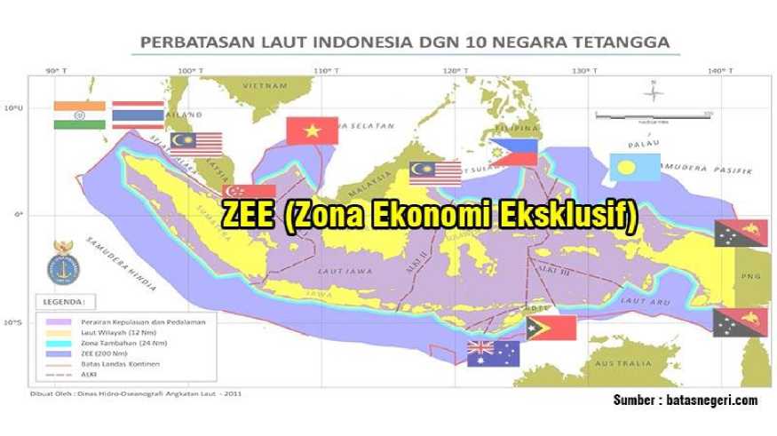
Figure 1 of Indonesia's EEZ Border Source: batasnegeri.com
National regulations governing the borders are as follows:
-
1. Law of the Republic of Indonesia Number 4 of 1960 on Indonesian Waters.
-
2. Law of the Republic of Indonesia Number 6 of 1996 on Indonesian Waters.
-
3. Law of the Republic of Indonesia Number 43 of 2008 on Territory of the State.
-
4. Law of the Republic of Indonesia Number 17 of 1985 on Ratification of UNCLOS
1982.
-
5. The Declaration of Djuanda 1957.
-
6. Territoriale ZEE en Maritieme Kringen Ordonantie 1939 (TZMKO 1939).
-
7. United Nations Convention on the Law of the Sea 1982 (UNCLOS 1982).
-
8. Law of the Republic of Indonesia Number 5 of 1990 on Conservation of Biological Natural Resources and Their Ecosystems.
-
9. Government Regulation Number 60 of 2007 on Conservation of Fish Resources.
Table 1. Determination of State Boundaries and Jurisdictions
|
No. |
Maritime Zone |
Legal Status |
Sovereignty / Jurisdiction |
Outermost Border |
|
1. |
Territorial Sea |
State Territory |
Sovereignty |
12 nautical miles |
|
2. |
Archipelagic Waters |
State Territory |
Sovereignty |
Baseline |
|
3. |
Internal Waters |
State Territory |
Sovereignty |
Closing lines in archipelagic waters |
|
4. |
Contiguous Zone |
Non-State Territory |
Sovereignty Rights |
24 nautical miles |
|
5. |
Exclusive Economic Zone |
Non-State Territory |
Sovereignty Rights and |
200 nautical miles |
|
Special Jurisdiction | ||||
|
6. |
Continental Shelf |
Non-State Territory |
Sovereignty Rights |
up to 100 nautical miles from isobath 2,500 meters, or 200–350 nautical miles |
Source: (Kurnia, 2021)
Settlement of disputes between countries can be reached utilizing a peaceful settlement and by force. Each solution alternative has its advantages and disadvantages. Peaceful settlement is the primary choice before a forced settlement is chosen.
An amicable settlement is a settlement by consensus to find a friendly solution.
-
1. Negotiation is in which the conflicting parties establish a direct relationship to discuss the disputed issue.
-
2. Mediation is the resolution of the problem through a third party as a mediator.
-
3. Arbitration is the submission of cases to certain people (arbitrators) who are freely chosen by the parties who make decisions without being bound by legal considerations. Settlement is a faster settlement with representatives from each party.
-
4. Adjudication is submitting a decision to a permanent judicial institution (International Court)
-
5. Through the United Nations forum with the General Assembly and the UN Security Council. These two forums are part of the United Nations forum.
-
6. Conciliation is a forum that is almost the same as conciliation with compromise in acceptable ways to the parties concerned.
Settlement by force, among others, through:
-
1. War, a contest (match) between the armed forces of two or more countries with the primary goal of defeating the other.
-
2. A retort is a retaliation by a country for unfriendly acts by another country, such as severance of diplomatic relations.
-
3. Reprisal, a way to ask for compensation from another country.
-
4. Blockade, an act to force a country whose ports are blockaded.
-
5. Intervention, involvement of the government of one country against the government of another country.
The Natuna Regency is situated in Indonesia's Riau Islands Province. The northernmost archipelago in the Riau Islands' Karimata strait is called Natuna. Natuna borders many nations in the north, including Vietnam and Cambodia. Natuna shares boundaries with South Sumatra and Jambi provinces to the south. In the west, Natuna shares boundaries
with the Riau Province, Singapore, and Malaysia. Natuna shares a border with West Kalimantan Province and East Malaysia to the east. One of the international maritime routes to Hong Kong, Japan, South Korea, and Taiwan passes through Natuna. The Natuna Regency is well known for being an oil and gas producing region. The estimated reserves of oil and natural gas in Natuna total 1,400,386,470 barrels and 112,356,680,000 barrels, respectively. The kekah is an animal that is unique to the Natuna Islands.
It is impossible to separate the history of the Riau Islands Province from that of the Natuna Regency. Natuna Regency was a component of the Riau Islands Province until becoming an autonomous territory. The Natuna Regency was established in accordance with Law of the Republic of Indonesia Number 53 of 1999, which was ratified on October 12, 1999. Faisal Tanjung, the interim minister of home affairs general of the Indonesian Armed Forces, officially inaugurated the regency.
Based on its history, the Decree of the Delegation of the Republic of Indonesia, Central Sumatra Province dated 18 May 1956 to merge into the territory of the Republic of Indonesia and the Riau Islands was given the status of a Level II Autonomous Region led by a Regent as the regional head in charge of the following four jurisdictions:
-
• The Tanjungpinang Jurisdiction, including the District of South Bintan (including East Bintan, Galang, West Tanjungpinang, and East Tanjungpinang).
-
• Karimun Jurisdiction, including Karimun, Kundur, and Moro sub-districts.
-
• Lingga Jurisdiction, including Lingga, Singkep, and Senayang sub-districts.
-
• Pulau Tujuh Jurisdiction, including the Districts of Jemaja, Siantan, Midai,
Serasan, Tembelan, West Bunguran, and East Bunguran.
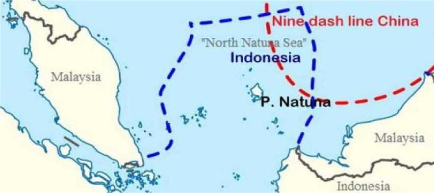
Figure 3 EEZ Boundary for North Natuna Waters Source: Berlianto (2020)16
According to the Decree of the Governor of Riau Province Number UP/247/5/1965 dated 9 August 1964, the Districts of Jemaja, Siantan, Midai, Serasan, Tambelan, West Bunguran, and East Bunguran, along with other jurisdictions, were abolished and are now under the control of the Pulau Tujuh Jurisdiction. As a result of this decision, all
-
16 Berlianto. (2020). Mengenal Nine Dashj Line Alasan China Mengklaim Natuna
administrative divisions within the Riau Islands Regency were abolished as of January 1, 1966.
According to Law of the Republic of Indonesia Number 53 of 1999, Natuna Regency was established as a result of the division of Riau Islands Regency, which had six subdistricts: East Bunguran, West Bunguran, Jemaja, Siantan, Midai, and Serasan, as well as one Tebang Ladan Sub-district. Natuna Regency then increased the territory of the subdistricts, which until 2004 contained ten sub-districts with the inclusion of Pal Matak, Subi, North Bunguran, and Pulau Laut sub-districts with 53 villages. This was done in conjunction with the authority of regional autonomy.
Up until 2007, Natuna Regency had 16 sub-districts, with a total of 75 sub-districts. The six new divisions are Pulau Tiga, Northeast Bunguran, Central Bunguran, South Siantan, and East Jemaja. The Anambas Islands Regency was established in 2008, dividing the Natuna Regency into 12 districts. Then, there were 66 sub-districts and 70 villages up to 2015. In order to make 16 districts, there will be an additional three sub-districts.
Riau was at first a province. In accordance with Law of the Republic of Indonesia Number 25 of 2002, Riau Province was renamed Riau Province and Riau Islands Province on September 24, 2002. Ranai served as the capital city of Natuna Re,gency.
The Natuna Islands have a total land and sea area of 264,198.37 square kilometers. Reporting from the official website of the Ministry of Maritime Affairs and Fisheries of the Republic of Indonesia, Natuna consists of 12 districts. Natuna is located between 1° 16' - 7° 19' North Latitude and 105° 00' - 110°00' East Longitude. Around 99 percent of the total area of Natuna is the sea. Various marine commodities are the main natural wealth of the Natuna Islands. The Natuna Sea also has excellent potential to be developed in the future. The potential of Natuna marine fish resources in 2011 was 504,212.85 tons per year or about 50 percent of the potential of the State Fisheries Management Area of the Republic of Indonesia (WPP RI) 711 in the Natuna Sea.
In 2014, the utilization of Natuna fish production reached 233,622 tons or 46 percent of the total sustainable potential of fish resources. Fishery commodities in Natuna are divided into two categories, namely pelagic fish and demersal fish. The potential of pelagic fish in Natuna reaches 327,976 tons per year, with the allowable catch of 262,380,8 tons per year or 80 percent.
In 2014, the utilization rate of pelagic fish only reached 37.8 percent,t or 99,037 tons. The remaining 163,343.8 tons per year has not been utilized. Pelagic fish live on the surface of the water to ponds between 0-200 meters. Pelagic fish have a habit of living in groups. Based on their size, pelagic fish are divided into small and large pelagics. For example, tuna, swordfish, marlin, skipjack, mackerel, and others. Examples of small pelagics are selar, anchovies, mackerel, cob, and others.
Furthermore, the potential for demersal fish reaches 159,700 tons per year, while the utilization rate in 2014 was only 40,491 tons or 25 percent per year. This means that there are still around 119,209 tons per year of untapped demersal fish potential in Natuna.
Demersal fish are fish that live on the seabed, either to find food or spawn. Demersal fish are divided into two types, namely benthic and benthopelagic. Several types of fish in Natuna that can be developed include grouper fish, tuna krai, anchovies, mackerel, yellowtail, selar, mackerel, white shrimp, tiger shrimp, crab, small crab, squid, and cuttlefish. Fishing areas in Natuna are located around Bunguran Island, Natuna Besar, Coastal Natuna Island, Midai, Serasan Island, Tambelan, and the South China Sea. Locations for catching giant crabs are generally located outside the 4 nautical mile location in the Natuna Sea area, South China Sea.
The Natuna Islands have great fishery potential. Fishing by foreign fishing vessels is common. This has violated the territory of Indonesia.
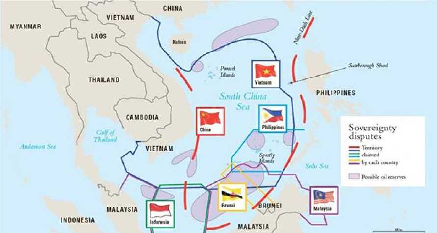
Figure 4 Nine-Dash Line and EEZ
Source: 17
The Nine-Dash Line is an area of the South China Sea covering an area of 2 million square kilometers of which China claims 90 percent of its historical maritime rights. This line was drawn by China unilaterally, without going through negotiations with the Indonesian side. Meanwhile, both Indonesia and China have ratified UNCLOS 1982. As a follow-up to these actions, both Indonesia and China are subject to the principle of Pacta Sunt Servanda.
The Nine-Dash Line area includes the Parcel islands which are also claimed by Vietnam and Taiwan, to the sea in the Spartly Islands where China has disputes with the Philippines, Malaysia, Vietnam, and Brunei Darussalam. China claims that the Natuna waters are part of its territory, both land and water.
-
17 Dingli, S. (2015). Maintaining Peace And Tranquility in the South China Sea.
Nine-Dash Line was originally called Eleven-Dash-Line when it was published on 1 September 1947 by the Republic of China (Taiwan). In 1952, the Eleven-Dash Line was abolished and turned into the Nine-Dash Line by Prime Minister Zhou Enlai. Claims on the Nine-Dash Line continue to this day.
In 2009, there was a water dispute between China and the Philippines. In its development, China has increased its claim to the Ten-Dash Line in 2013. The Ten-Dash Line not only covers the South China Sea, but covers the sea east of Taiwan as well.
In the 19th century, the Natuna Islands with its seven surrounding islands were the territory of the Riau Sultanate. On 18 May 1956, it was registered as the property of the Republic of Indonesia to the United Nations. The fact that the Natuna Islands belong to Indonesia has a long historical record. The Natuna Islands, which consists of several islands, became the battleground between the two great powers of the time, the Dutch and the British Empire, in the early years of the arrival of European colonists. The Dutch chose to establish a defense center and port in Malacca after previously removing the Portuguese from the Malacca region.
The British chose Bengkulu on the East Coast of Sumatra as their base. The British built a trading office in Tanjungpinang to control trade in the Straits of Malacca. Endless conflicts caused a lot of losses between England and the Netherlands, prompting both of them to enter into the Anglo-Dutch Treaty in 1824 to divide the boundaries of their colonial territory. In the written agreement, the maritime boundaries in the Malacca Strait and the previously blurred South China Sea were firmly established between the Netherlands and Britain.
The British gained territory in the North and East of the Straits of Malacca which included the Malay Peninsula and Singapore. The Dutch gained the South and the West with the strait falling into Dutch hands. Areas owned by the Dutch include Sumatra Island, Lingga Islands, and Riau. The British also had to leave Bengkulu.
When the agreement was made, the northern part of the island of Borneo, now Kalimantan, was still controlled by the Sultanate of Brunei. When the Kingdom of Brunei experienced a decline, the British took over the territory of Borneo. This reason later made Natuna which fell to Indonesia flanked by two main areas of the neighboring country. After Malaysia's independence from the British, the Kalimantan region was divided into two, namely Sabah and Sarawak. The southern side of Kalimantan became Indonesian territory after independence. As a consequence, the territories of the Dutch East Indies, including the Natuna Islands, became the territory of Indonesia.
During World War II, although the period was short, all of the territory in Malaya and the South China Sea was controlled by the Japanese military. Indonesia is in dispute with China regarding the South China Sea area. However, Indonesia is not the only country. Beijing is in dispute with six countries in Southeast Asia with overlapping borders.
North Natuna waters have enormous biological resources. Various types of fish and other biological marine resources are in these waters. Biological resources are dependent on one another in an ecosystem. However, these biological resources cannot be limited by ownership of the sea. Biological resources can move from one area to another.
Countries around the North Natuna waters have the same interests. Utilization of biological resources will have a long-term impact on human life, if there are certain countries that use technology for the exploitation of biological resources. As a result, the life of these biological resources will become extinct due to disturbed ecosystems. This biological resource is not limited by the territory of a country, because it is in the waters. The Indonesian government needs to take the right policies in resolving disputes in the waters of North Natuna. The policies of the Indonesian government will affect the countries around the North Natuna waters. The biological wealth of these countries will be affected by the policies of the Indonesian government. The Indonesian government must consider the environmental impacts that will and may occur in the waters of North Natuna. The environmental impact on the waters of North Natuna will also have an impact on other Indonesian waters, such as Java waters and may even affect the waters of other countries.
This means that the Indonesian government must strive to remain committed to maintaining and securing biological resources, including fish resources, so that these resources can be utilized in accordance with the carrying capacity and environmental conditions of biological resources. This is in order to fulfill the principles of conservation, which consist of benefits, equity, partnership, equity, integration, openness, efficiency, and sustainability.
The difference in the principle of regional regulation on land and at sea is that if on land only recognizes the definition of territory which is juridically limited to issues of sovereignty, then at sea, in addition to being recognized as territorial waters that are under state sovereignty, jurisdictional areas are also recognized which are not included in the territory of state sovereignty. In detail, the law governing the territory of the Unitary State of the Republic of Indonesia (NKRI) provides the definitions of territorial waters and jurisdictional areas.18
-
3.8 The dispute over the North Natuna waters cannot be resolved by the Government of Indonesia until now
The dispute over the North Natuna waters has been going on for a long time. This dispute is still ongoing today. The Indonesian government takes firm action against violations of the North Natuna waters. However, this violation is still ongoing.
Jakarta and Beijing have good bilateral relations. China has become one of Indonesia's main export destinations. On the other hand, Indonesia is also a destination for China's
exports. Cooperation between Jakarta and Beijing also occurs in various fields. China is one of the parties that built the Jakarta-Bandung high-speed railway. China has also provided Indonesia with COVID-19 pandemic vaccines. In addition, the two countries are also cooperating in various conservation activities, such as the Panda Conversation, cooperation between the Chinese central bank and Bank Indonesia on the use of currency in transactions between the two countries. This good bilateral relationship between Beijing and Jakarta will facilitate the settlement of disputes over the North Natuna waters. Jakarta and Beijing maintain good relations and do not want the dispute over the North Natuna waters as an obstacle in building good relations between the two countries as a whole. The North Natuna maritime dispute will remain as long as the two sides have good bilateral relations.
The dispute in the North Natuna waters will become a serious dispute, if there is pressure on the relevant government or there is an intervention that seriously disturbs the sovereignty of other countries. The North Natuna water dispute will become an open dispute, if there is a serious violation by one country against another country. If there are no serious violations and bilateral relations are getting better, the North Natuna water dispute will continue to exist.
In addition to economic considerations, the two countries are also big countries in Asia. Both countries have an interest in political stability in the Asian region. The two countries are more focused on the economy than the dispute.
Good relations between Jakarta and Beijing can be resolved through bilateral channels. The dispute over the North Natuna waters must be resolved peacefully. Settlement by peaceful means can be reached by negotiation. The negotiation can be carried out with good relations between Jakarta and Beijing.
Negotiations can be carried out by developing cooperation in the development of the North Natuna region. The development of the Natuna area will provide benefits for both parties. The development of Natuna will provide benefits to the surrounding community. Competition between local and foreign fishermen can be avoided.
The negotiation alternative with a joint regional development plan is the best solution. Settlement through arbitration, mediation, or through UN forums is not able to facilitate cooperation between countries. Negotiations will be able to produce a joint development plan.
-
4. Conclusions
The Natuna region cannot be separated from the Riau region. Riau region has become the territory of the Republic of Indonesia. Meanwhile, China made claims to the North Natuna waters unilaterally based on the Nine-Dash Line. Dispute resolution can be reached through several ways from using military forces to diplomatic negotiation. At this time, countries will tend to choose the path of peaceful settlement. The settlement of disputes in the North Natuna waters can be resolved bilaterally. Good relations between
Jakarta and Beijing can be resolved without the need to involve third parties. Many countries have interests in North Natuna waters. North Natuna waters contain a large wealth of biological resources. This source of living life has an ecosystem that is not limited to marine waters. The power of one biological resource will have an effect on other biological resources. Therefore, the Indonesian government must take the right policy in resolving the dispute over the North Natuna waters. This research focuses on the overall benefit, where the waters of North Natuna are part of the cooperation between the two countries. This research has shortcomings in terms of the implications of the dispute over the North Natuna waters on the internal politics of each country. In addition, research can be developed on the economic impact on the surrounding community in the disputed area.
References
Book
Berlianto. (2020). Mengenal Nine Dashj Line Alasan China Mengklaim Natuna
Dingli, S. (2015). Maintaining Peace And Tranquility in the South China Sea.
Kurnia, I. (2018). Aspek Nasional dan Internasional Pemanfaatan Surplus Perikanan di Zona Ekonomi Ekslusif Indonesia. In Sinar Grafika.
Journal
Adiananda, I. D. A. M., Pratama, I. G. E. B., & Manik Utama, I. A. B. (2018). Problematika Penegakan Hukum Dalam Tindak Pidana Illegal Fishing di Wilayah Perairan ZEE Indonesia. Jurnal Magister Hukum Udayana (Udayana Master Law Journal), 8(2), 237–248. https://doi.org/10.24843/jmhu.2019.v08.i02.p07
Adikara, A. P. B., & Munandar, A. I. (2021). Tantangan Kebijakan Diplomasi Pertahanan Maritim Indonesia Dalam Penyelesaian Konflik Laut Natuna Utara. Jurnal Studi Diplomasi Dan Keamanan, 13(1), 83–101.
https://doi.org/10.31315/jsdk.v13i1.4365
Hetharia, O. G. (2017). Pengaturan Landas Kontinen Menurut UNCLOS 1982 Dan Implementasinya di Indonesia. Lex Administratum, V(9), 138–146.
Kalembang, J. V. (2020). Analisis Sengketa Zona Ekonomi Eksklusif Antara Indonesia dan RRT di Kepulauan Natuna. Journal of Politic and Government Studies, 9(4), 114.
Kusumaningtyas, M. A., Bramawanto, R., Daulat, A., & S. Pranowo, W. (2014). Kualitas perairan Natuna pada musim transisi. Depik, 3(1), 10–20.
https://doi.org/10.13170/depik.3.1.1277
Johan, S. (2021). Knowing Company Secrest Thru Employee Post in Media Social. Diponegoro Law Review, 6(2), 203–216.
https://doi.org/10.14710/dilrev.6.2.2021.203-216;
Johan, S., & Ariawan, A. (2021a). Corporate Liability for Creditor’s Losses during the Covid-19 Pandemic. Jurnal Media, 28(1), 15–28.
https://doi.org/10.18196/jmh.v28i1.10566
Johan, S., & Ariawan, A. (2021b). Keterbukaan Informasi UU Pasar Modal Menciptakan Asymmetric Information Dan Semi Strong Form. Masalah-Masalah Hukum, 50(1),
Marzuki, M. P. (2017). Penelitian Hukum: Edisi Revisi (Revisi). Retrieved from https://opac.perpusnas.go.id/DetailOpac.aspx?id=1409842
Novianto, R. D., Firmansyah, D. A., & Pratama, N. A. (2020). Penyelesaian Sengketa di Laut Natuna Utara. Jurnal Hukum Bisnis Bonum Commune, 3(1), 69–78.
Pradana, R. (2017). Akibat Hukum Klaim Nine Dash Line Cina Terhadap Hak Berdaulat Indonesia. Ilmiah, 1–8.
Riry, W. A. (2021). Ratifikasi Perjanjian International Sebagai Salah Bentuk Politik Hukum Nasional. Syntax Transformation, 2(2), 244–250.
Simanjuntak, M. (2020). Menolak Klaim Histor Is China “ Nine Dash Line ” Dan Kewenangan Penegakan Kedaulatan. Jurnal Ilmiah Hukum Dirgantara, 10(2), 150– 162.
Suryadinata, L. (2016). Did the Natuna Incident Shake Indonesia-China Relations? Perspective, (19), 1–8
Regulation
The United Nations Convention of the Law of the Sea (UNCLOS) 1982.
Law of the Republic of Indonesia Number 53 of 1999, which was ratified on October 12, 1999.
Decree of the Governor of Riau Province Number UP/247/5/1965 dated 9 August 1964.
Others
BBC News Indonesia. (2020). Natuna: China dan Indonesia sepakat tidak ada sengketa soal ZEE, “demi stabilitas kawasan.” BBC News Indonesia. Retrieved from https://www.bbc.com/indonesia/indonesia-51143850
Kurnia, I. (2021). Bahan Kuliah Mata Kuliah Hukum Transnasional. Universitas Tarumanagara.
Jurnal Kertha Patrika, Vol. 45, No. 1 April 2023, h. 79-92
Discussion and feedback