Numerical Simulation of Tsunami Hazard Mitigation by Mangrove Forest in North Coast Bali, Indonesia
on
Jurnal Matematika Vol. 5 No.1, Juni 2015. ISSN: 1693-1394
Numerical Simulation of Tsunami Hazard Mitigation by Mangrove Forest in North Coast Bali, Indonesia
Putu Harry Gunawan 1,2
-
1 Industrial and Financial Mathematics Research Group, Faculty of Mathematics and Natural Sciences, Institut Teknologi Bandung, Jalan Ganesha 10,
Bandung 40132, Indonesia
-
2 Universite Paris-Est, LAMA UMR8050, F-77454, Marne-la-Vallee, France.
e-mail: harry.gunawan.putu@gmail.com; putu-harry.gunawan@u-pem.fr
Abstract: Mangrove forest or known as bakau forest is important forest as a natural wave barrier or tsunami wave mitigation. Some advantages of mangrove forest to reduce the water waves are already studied. Mangrove forest in north coast of Bali’s island, Buleleng regency, Indonesia is in damaged condition. The aim of this paper is to present the importance of mangrove forest as the water wave mitigation in numerical simulation point of view. Moreover, the results also show the effect of tsunami propagation to the coastal area with and without mangrove resistance. Here, the nonlinear shallow water equations are used to govern the model of numerical simulation.
Keywords: Numerical simulation, Tsunami, Mangrove, Shallow water equations
Abstrak: Hutan mangrove atau dikenal sebagai hutan bakau sangat bermanfaat
sebagai penahan atau peredam gelombang laut alami. Beberapa studi literatur mengenai manfaat hutan bakau sebagai peredam gelombang sudah banyak dipublikasikan. Hutan bakau yang berada dikisaran pesisir pantai Bali utara, kabupaten Buleleng, Indonesia sudah dalam kondisi rusak. Hal ini membuat penulis ingin melihat bagaimana manfaat hutan mangrove sebagai peredam gelombang dengan simulasi numerik. Makalah ini memberikan gambaran akan pengaruh ada atau tidaknya hutan bakau disaat gelombang air laut yang tinggi (contoh tsunami) bergerak menuju pesisir pantai Bali utara. Model matematika yang digunakan dalam makalah ini adalah mengguankan persamaan air dangkal tak linier (nonlinear shallow water equations).
Kata kunci: Simulasi numerik, Tsunami, Bakau, Persamaan air dangkal.
One of the famous touristic places in Indonesia is called Bali’s island or known as the thousand gods of island. The beautiful beaches and high ocean wave for surfing sport become the excess of other tourist attractions. Furthermore, the conservation of coastal vegetation places (for example mangrove park conservation) becomes other interesting sight for tourist domestics and internationals. The increasing of tourist
visitors in Bali causes the significantly development in touristic places. Therefore, one concern is that the impact of this development on environmental issue.
In the articles of Bali Post, [2] and Putri, [9], they mentioned that the mangrove forest in coastal area of north Bali region has been damaged 85 hectare from 278 hectare outside of Taman Nasional Bali Barat (TNBB) area. They believe that this damages caused by human behaviour that deliberately cut down the mangrove forest. They intentionally destroy the mangrove forest for expanding their own personal land since the price of land is increased significantly in coastal area.
The important of mangrove forest as a natural barrier which is a completely sustainable barrier for ocean wave hazard has been studied recently. For example, in papers of Teh, et. al., [11] and Yanasigawa, et. al., [12], they study about the tsunami mitigation by mangrove forest. Moreover, the capability of mangrove resistance to reduce the tsunami wave also has been shown efficiently. The presence of mangrove forest also as a protection for other organisms which are lied behind the mangrove forest when the tsunami attacks.
The aim of this paper is to elaborate the numerical simulation of tsunami propagation in north coast Bali’s island with and without the presence of mangrove forest. Moreover we would like to see how the advantages from preserve and maintain the mangrove forest along the coastal area. Due to the limitation of our tools such as the real data of topography, current speed, wind speed, etc, for our numerical simulation, we can say that this paper is a preliminary study of the effect of mangrove forest from tsunami hazard. Here, we use the shallow water equations and staggered finite volume approximation (see Gunawan, [5]; or Stelling, et. al., [10] for instance) for modelling the propagation of tsunami wave through mangrove forest.
This paper is organized as follows, the governing equations such as the 2D shallow water equations, mangrove resistant model and numerical scheme are described in Section 2. Numerical simulations in one and two dimensional are given in Section 3. Finally, in Section 4, the conclusions are drawn.
For simulating the tsunami propagation through the mangrove forest, we need the governing equations for both tsunami wave and mangrove forest parts. In this subsections bellow, we will introduce some governing equations to elaborate our numerical simulation.
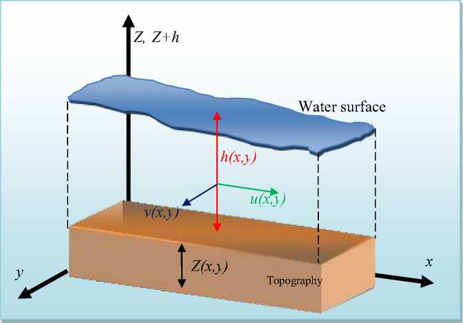
Figure1. The illustration of 2D shallow water equations
A simple model where the fluid and mangrove effect coupled together is described in nonlinear shallow water equations. Shallow water equations are the hyperbolic equations which can describe the water flow phenomena such as in coastal area, rivers, channels, estuaries, etc. The mangrove effect is described in nonlinear shallow water equations as a friction term. The two dimensional conservative form of nonlinear shallow water equations is given as:
∂t (h) + ∂x(hu) + ∂y(hv) = 0(1)
∂t(hu) + Xx .hu2 + ^gh2/ + ∂y(huv) + ghSf x = —ghXxZ(2)
∂t(hv) + ∂x(huv) + yy .hu2 +-^gh2/ + ghS f y = —ghyzZ(3)
where h is the water height, Z the topography, g the gravitational force and u and v are the lateral velocity in %-and y directions respectively (see Figure 1). The friction terms (in this case the mangrove resistance) in -and directions are denoted as and respectively.
The friction terms and are defined in two ways. First, the friction terms
can be considered by Manning’s or Darcy-Weisbach’s friction law depend on the flow conditions. For example, when the flow is laminar, the Manning’s friction law is suitable and contrary the Darcy-Weisbach’s friction law is suitable when the flow is turbulence. The second way is use the Morison equation where the structure of 3
mangrove three is considered. The detail of above frictions terms will be explored in the next section.
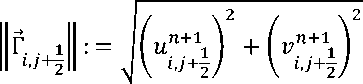
There are two methods to describe the mangrove friction in shallow water equations. First, we can assume that mangrove frictions are accumulated uniform under Manning’s or Darcy friction law. Let we denotes Γ⃗=(U,V) and ‖Γ⃗‖=√U2 + V2 , then the Manning’s friction law are given as
s= ‖Γ⃗‖ , = ‖Γ⃗‖ 'L
(4)
ℎ4/3, ℎ4/,
and the Darcy-Weisbach’s friction law are given as
‖Γ⃗‖ U
Sfx = 8gℎ,
‖Γ⃗‖ Z
= 8gℎ․
(5)
The second model of mangrove resistance is to consider the structure of mangrove trees (see Figure 2). This model is known as the Morison equation can be seen for one dimensional case in Yanasigawa, et. al., [12]. In this paper we will not use this type of mangrove model. Perhaps we can introduce this model in another paper. Therefore, we exclude the derivation of Morison equation for 2D nonlinear shallow water equations.
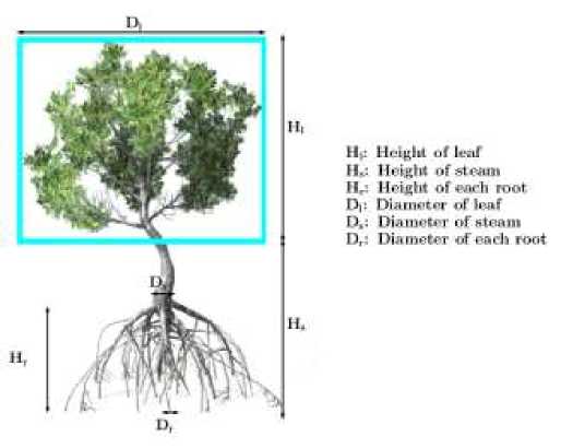
Figure 2. The Structure of Mangrove Tree. The blue box describes the projected area of trees of mangrove.
In order to approximate Eqs. (2.1-2.3), some methods are available. In finite volume approach, the collocated (see Audusse, et. al., [1]; Bouchut, [3]; Leveque, [7]; or Delestre, [4]; for instance) and staggered grid (see Gunawan, [5]; or Stelling, et. al., [10]) schemes are available. In this paper, we use the well-balanced staggered finite volume scheme which is shown as a robust and simple scheme by Gunawan, [5]. The full discretization of mass and momentum balance two dimensions conservative form of nonlinear shallow water equations (1-3) can be found in Gunawan, [5]: Chapter 2; in detail. However, in Gunawan, [5]; the discretization of friction terms in two dimensions is not available. Therefore, here we only consider the numerical scheme of mangrove resistance/ friction in two dimensions.
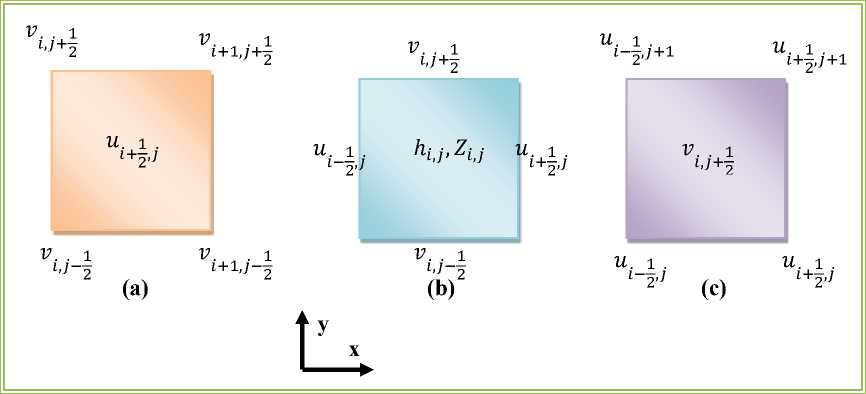
Figure 3. The control volume of mass (b), momentum in X- (a) and y- (c) directions.
First, let’s we define the discrete notation of our domain. For simplicity, we consider a rectangular space domain Ω := [0, Lx] × [0, Ly]. The domain is meshed with a rectilinear grid of XXx × Ny cells. The discretization of mass and momentum (1-3) is using the Arakawa-C grids, where some variables (h and Z') are discretized in full grid and the others ( and ) in half grid (see the control volume for mass and momentum conservation in Figure 3). We set M = {1, -∙,Nx} × {1, - ∙,Ny} is the discretization of our domain. Then for all( i ,j') ∈ M, the discretization of the Manning’s friction law (4) are given as

' i : = K2 f G+1j)
r „,n+1
Γ 1 W. 1 .
l+2,j∣∣ t+2,j
> i : = K2 f(iJ+½)
n+1 illυ 2 Il l,j +2
+
4/3
(6)
and the Darcy-Weisbach’s friction law (5) are given as
Sfx — S i : — Cf ιx f(++2S> 1
1 l"^+i.
2,j Il ^+2,j
lr JR+11 ^,j + 2 ^,j + o , .
= Wr = c^^⅛τ^, (7) j ( t ,j+2) ogn 1
i ,7+7
where
8g⅛n+11. t+2,j
(vn+11 + vn+11 + vn+1 1 + vn+1
n+1 ∖ t,j'+2 t,j'-2 t + 1,j'+2 t + 1,j'
v, 1 .: =-----------------------------:------------------------
t⅛j 4
,
+
i ,j+2
(un+11. + un+11. + un+11. +un+11.
y i +7, j i—7, j +"r+ 1 ^-2, j
4
)
,
. n+1 W 1 + /" )
M.j: =------2------•
n +
i ,j+2
« 1 + ⅛⅜+1) 2
■
Here, we use the semi-implicit discretization for both friction terms. This method has some advantages, for example to preserve the positivity of water height and the steady state at rest (see for instance Delestre, [4] and Marche, [8]: 197). From the discretization n + 1 n + 1
above (6-7), we can see clearly that the v . 1 . and u. . 1 in the control volume of l ⅛j l
momentum ∕- and y-directions respectively (Figure 3 (a) and (c) respectively) are not available. Therefore, we define v. 1 . and W . . 1 by the averages of four neighbours t ⅛j t,j⅛
points in each control volumes. This method also can be found in the book of Kämpf, [6]; for non-conservative form of nonlinear shallow water equations.
In this section we present the numerical simulations of effect of mangrove forest to reduce the ocean waves such as tsunami.
In this section, we try to elaborate a numerical simulation of wave damping by mangrove forest in 1D shallow water equations. Recall again the 1D model,
∂t (h') + ∂x(hu) = 0,
∂t(hu) + Xx (hu2 + 1 gh2/ + ghκ2 ^ = -ghXxZ,
where h is the water height, Z the topography, g the gravitational force and u the uniform velocity in % - directions. Here the initial conditions of this simulation Ω = [0: L] m with L = 100 are given as
( h(x, 0) = 1 m,
∖ Z (x, 0) = 0 m,
(u(x,0) = 0 ms- 1.
The grid spacing Δx = 0.5 m is used in this simulation. The mangrove forest is located from 5 L/8 m until 3 L/4 m . Here, we used the Manning’s friction law, with the Manning’s coefficient is set to be κ = 0.5. The right boundary condition is set to be an open boundary condition. Meanwhile, the left boundary condition is used for generating the wave paddle with,
h(0,t) = ∣A sin(^)|, u(0,t) = 2∣A sin(^)|, where A = 1.5 m is the amplitude and Tp = 4 s is the period of sea level oscillations.
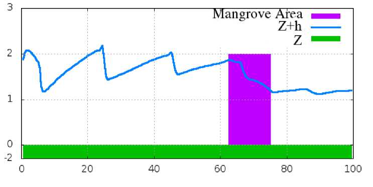
Figure 4. The wave damping by mangrove in 1D shallow water equations.
The result of this simulation at final time T=40 s can be seen in Figure 4. We can see clearly that in Figure 4, the wave damps due to the presence of mangrove forest. The wave is decreasing after going through the mangrove area. Moreover, the shock in our results due to the mangrove area reduces the wave height, such that the velocity in the mangrove area is slow down. Therefore the flow will be reflected to the left such that the accumulation of incoming wave and reflection wave produce a shock in long time simulation. The validation of numerical scheme to the analytical solution for shallow water with friction term can be found in Gunawan [5].
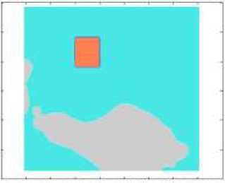
In this section, we present the numerical simulation of tsunami propagation along the north coast Bali, Indonesia. Assume that we have a tsunami generation in Bali sea located on latitude (-7.6, -7.9) and longitudinal (114.4, 115.8) with initial surface wave (see Figure 5 (a)) is given as
3,m if 114․8≤x≤115; -7․8≤у≤-7․6,
(ℎ+Z)(x,y,
0,m otherwise․
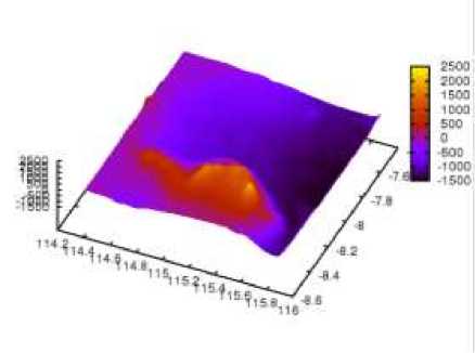
The initial wave is given in box shape and the boundary conditions are adjusted to open boundary conditions. The coarse data grids of real topography z(x,y) Bali’s island are obtained from website (http://topex.ucsd.edu). The topography is obtained from satellite altimetry and ship depth sounding.
1142 114 4 IW e IUB 115 1152 115 4 HS O 1158 116
(a)
(b)
Figure 5. (a) The initial configuration of tsunami propagation on Bali Sea. (b) The 3D plot of real topography of north coast Bali’s island.
Note that, the raw data topography from website above is too coarse and we need to refine about 2n grids from the raw data, where here n = 2 is used (see Figure 5 (b) for the 3D plot of real topography around Bali Sea). Moreover from the raw data, we cannot able to obtain detail data for mountains, rivers, lakes or coastal area. However, it is sufficient to use as an exercise for our tsunami simulation, since we only need the surface of seafloor. The detail of real topography seems difficult to obtain, especially for Indonesian archipelago. Therefore, trough this paper, we hope that the Indonesian government, scientist and engineering could see this problem and as soon as possible begin to provide the detail of real topography for future research purposes.
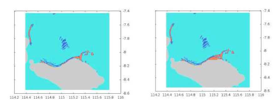
Here, the initial velocities u(x, y,)) and v(%, y, 0) for%- and y-directions respectively are set to be zero. The computational grids Nx × Ny , where Nx = 366 and Ny = 276 are used and final time t = 60 s is used. For the mangrove resistance, we used the Darcy-Weisbach’s friction law (5) with the discrete form (7), and the Darcy-Weisbach’s coefficient is set to be Cf = 60. The mangrove forest is installed along the north coast Bali with width about 10 meters from the mainland. The results at the final time simulation can be seen in Figure 6.
In Figure 6 (a), we can see clearly that in the presence of mangrove forest along the north coast Bali, the tsunami wave reduced before approaches the mainland. Meanwhile, the flooding phenomena occur in the mainland area since the absence of natural break water i.e. mangrove forest (Figure 6 (b)). More pictures of numerical simulation results can be found in Appendix A (with mangrove forest) and Appendix B (without mangrove forest).
(a)
(b)
Figure 6. The numerical simulation of tsunami propagation with (a) and without (b) mangrove forest in north Bali region.
Since we did not use detail topography, we could not provide more descriptions of our numerical simulation results. For examples, how deep the ocean water surface propagates to the mainland? How big the impact of mangrove forest to reduce the tsunami wave? And etc. Although, here we can only give some depictions of the important of mangrove forest, that are for damping the tsunami wave and preventing the mainland from flooding phenomena.
The numerical simulation of tsunami mitigation by mangrove in north coast Bali’s island has been done. The destruction of mangrove forest by human along the coast of north Bali’s island causes the loss of natural wave damping. From our numerical simulation, the flooding probably occurs when the high coastal wave (for instance tsunami wave) propagates to the mainland without mangrove forest in coastal area. Therefore, from this paper we can conclude that the mangrove forest in north coast Bali should be preserved and maintained as a natural barrier from tsunami hazard.
References
-
[1] Audusse, E., Bouchut, F., Bristeau, M. O., Klein, R., & Perthame, B. 2004. A Fast and Stable Well-Balanced Scheme with Hydrostatic Reconstruction for Shallow Water Flows. SIAM Journal on Scientific Computing, 25(6), 2050-2065.
-
[2] Bali Post. “98 Hektar Hutan Mangrove di Buleleng Rusak Parah”, 19 October 2012, www.facebook.com/balipost/posts/395534973846483.
-
[3] Bouchut, F. 2004. Nonlinear Stability of Finite Volume Methods for Hyperbolic Conservation Laws: And Well-Balanced Schemes for Sources. Frontiers in Mathematics, Birkhäuser Verlag, Basel.
-
[4] Delestre, O. 2010. Simulation du Ruissellement D'eau de Pluie Sur des Surfaces Agricoles. Doctoral Dissertation. Université d'Orléans.
-
[5] Gunawan, P. H. 2015. Numerical Simulation of Shallow Water Equations and Related Models. Doctoral Dissertation. Institut Teknologi Bandung & Université Paris-Est Marne-la-Vallée.
-
[6] Kämpf, J. 2009. Ocean Modelling for Beginners: Using Open-source Software. Springer Science & Business Media.
-
[7] LeVeque, R. J. 2002. Finite Volume Methods for Hyperbolic Problems (Vol. 31). Cambridge University Press.
-
[8] Marche, F. 2005. Theoretical and numerical study of shallow water models: applications to nearshore hydrodynamics. Doctoral Dissertation. Laboratoire de mathématiques appliqués. Université de Bordeaux I.
-
[9] Putri, C. WWF-Indonesia Segera Reforestasi Hutan Mangrove di Pesisir Bali, WWF Indonesia, 15 September 2014, http://www.wwf.or.id/?35222/WWF-Indonesia-Segera-Reforestasi-Hutan-Mangrove-di-Pesisir-Bali.
-
[10] Stelling, G. S., & Duinmeijer, S. P. A. 2003. A Staggered Conservative Scheme for Every Froude Number in Rapidly Varied Shallow Water Flows. International Journal for Numerical Methods in Fluids, 43(12), 1329-1354.
-
[11] Teh, S. Y., Koh, H. L., Liu, P. L. F., Ismail, A. I. M., & Lee, H. L. 2009. Analytical and Numerical Simulation of Tsunami Mitigation by Mangroves in Penang, Malaysia. Journal of Asian Earth Sciences, 36(1), 38-46.
-
[12] Yanagisawa, H., Koshimura, S., Goto, K., Miyagi, T., Imamura, F., Ruangrassamee, A., & Tanavud, C. 2009. The Reduction Effects of Mangrove Forest on a Tsunami Based on Field Surveys at Pakarang Cape, Thailand and Numerical Analysis. Estuarine, Coastal and Shelf Science, 81(1), 27-37.
Appendix A. Numerical simulation with mangrove forest
The sequential results of numerical simulation with mangrove forest
t= 4.08 s
t=10.88 s
-7,4 r ...... , , —n -7 4
B 2 ■ B.2

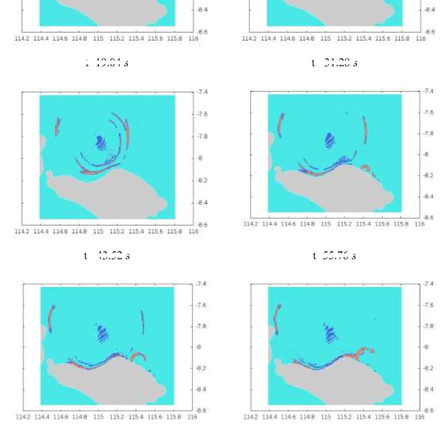
t=19.04 s
t= 31.28 s
t= 43.52 s
t=55.76 s
Appendix B. Numerical simulation without mangrove forest
The sequential results of numerical simulation without mangrove forest.
t= 4.08 s
t=10.88 s
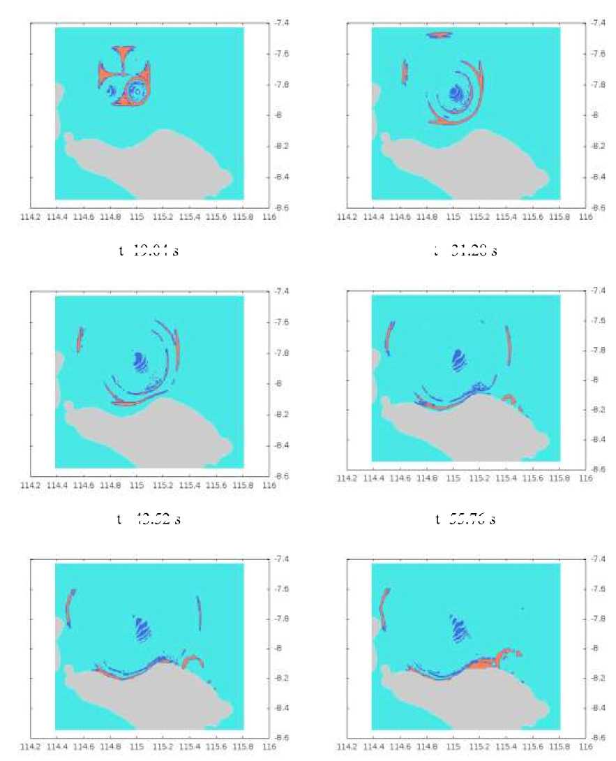
t=19.04 s
t= 31.28 s
t= 43.52 s
t=55.76 s
13
Discussion and feedback