MAPPING OF MARINE PLANTS DISTRIBUTIONS IN NORTH COASTAL AREA OF SUMBAWA REGENCY USING ALOS/AVNIR-2 DATA
on
Ecotrophic ♦ 5 (1): 45 - 50
ISSN: 1907-5626
MAPPING OF MARINE PLANTS DISTRIBUTIONS IN NORTH COASTAL AREA OF SUMBAWA REGENCY USING ALOS/AVNIR-2 DATA
S.P. Astuti1), T. Osawa 2), I N. Merit 3)
-
1) Senior High School of Oceanografi, West Nusa Tenggara
-
2) Center for Remote Sensing and Oceanography Science, Udayana University
-
3) Agriculture Faculty, Udayana University
ABSTRAK
Pemanfaatan dan pengelolaan sumberdaya bahari akan lebih menguntungkan jika didahului dengan studi aspek biologi, disamping aspek fisik dan parameter kimia air. Studi tentang aspek biologi dapat dilakukan dengan pemantauan perubahan ekosistem (biomonitoring). Salah satu aspek yang dilibatkan dalam biomonitoring adalah pemantauan mengenai perubahan luas tumbuhan laut. Tumbuhan laut terdiri atas lamun dan alga laut. Penggunaan ALOS dengan sensor AVNIR-2 dalam penelitian ini karena mempunyai 3 spectrum tampak (biru, hijau, merah) yang mampu berpenetrasi ke dalam kolom air, juga mempunyai resolusi spasial yang cukup tinggi yaitu 10 meter.
Tujuan penelitian ini adalah: (1) untuk mengetahui kombinasi band mana yang lebih baik dalam penerapan metode Lyzenga untuk pemetaan tumbuhan laut dan (2) untuk mengetahui sebaran jenis tumbuhan laut secara umum di pantai utara Kabupaten Sumbawa.
Metode Lyzenga digunakan dalam pengolahan citra untuk mengetahui kombinasi band yang lebih baik. Tahap awal pengolahan citra adalah pemotongan citra, koreksi geometrik dan koreksi radiometrik. Pengaruh kolom air direduksi dengan algoritma Lyzenga. Enam kelas ditentukan dengan proses klasifikasi multispektral yaitu: lamun, alga laut, karang, pasir kasar dan pecahan karang, pasir halus dan substrat. Pengambilan data lapangan dilakukan untuk mengetahui tingkat ketelitian interpretasi setiap citra dari perpaduan band-band. Metode Lillesand dan Kiefer (1990) digunakan untuk uji ketelitian hasil interpretasi.
Hasil uji yang lebih baik dihasilkan oleh citra dengan kombinasi band 1 dan band 2 dengan tingkat ketelitian klasifikasi sebesar 86,67%. Lamun yang ditemukan di pantai utara Kabupaten Sumbawa, terdiri atas empat jenis yakni Cymodocea rotundata, Enhalus acoroides, Syringodium isoetifolium, dan Halophila ovalis, dengan luas keseluruhan 835,37 ha. Alga laut yang ditemukan terdiri atas lima jenis yakni Euchema cottoni, Euchema cottoni ssp sakul, Halimeda sp, Padina sp, dan Sargasum duplicatum dengan luas keseluruhan 269,16 ha.
Kata kunci: Sebaran tumbuhan laut, metode Lyzenga, citra satelit ALOS
ABSTRACT
The exploitation and management of water resource be more beneficial, if preceded by study which includes biological aspect besides physics and chemical parameter of waters. The biological aspects study can be conducted by monitoring the change of ecosystem (biomonitoring). One of study that entangles biomonitoring is the research concerning change of marine plants. Marine plants consists of seagrasses and seaweeds. Using ALOS/AVNIR-2 data in this research because it has 3 visible bands (blue, green, and red) with 10 meter spacial resolutions can penetrate into water column.
Aims of research were (1) to know combinations of bands in ALOS/AVNIR-2 data was better in Lyzenga method applying to mapping marine plants, (2) to know the general species of marine plants in north coastal area of Sumbawa regency.
Lyzenga method was used in image processing process to know the combination of bands which have better for mapping marine plants. Preliminary steps of image processing were image cropping, geometric correction and radiometric correction. Water column effect was reduced by Lyzenga algorithm. Six classes were determined by multispectral classification process i.e. seagrass, seaweeds, coral, hard sand and rubble of coral, and substratum. Field surveys has done to identify the accuracy level. The accuracy method by Lillesand and Kiefer (1990) was used in this research.
The result of accuracy test show for image band 1 and band 2 combination given better visual object benthic than another combinations of bands, with overall accuracy was 86.67%. Seagrass found in north coastal area of Sumbawa regency consist of four species there were Cymodocea rotundata, Enhalus acoroides, Syringodium isoetifolium, and
Halophila ovalis with width equal to 835.37 ha, while seaweeds were found equal to five species there were Euchema cottoni, Euchema cottoni ssp sakul, Halimeda sp, Padina sp, and Sargasum duplicatum with width equal to 269,16 ha.
Key word: Distribution of marine plants, Lyzenga method and ALOS data.
INTRODUCTION
The exploitation and management of water resource be more beneficial, if preceded by study which includes biological aspect besides physic and chemical parameter of water. The biological aspects study can be conducted by monitoring the change of ecosystem (biomonitoring).
Biomonitoring is a very useful activity that can be use as a consideration in making decision about management and protection of water resources (Herricks and Caims, 1982; Nurdin, 2000). One of study that entangles biomonitoring is research concerning change of marine plants. Marine plants consist of seagrasses and seaweeds, that are vascular and non vascular plants which grow attached to the substrate in the bottom sea (Lerman, 1986; Toni, 2006).
The existences of marine plants are very importance in coastal area and sea.
This natural resources usually can be found in territorial water which have association with the existence of coral reef and mangrove ecosystem. The potency of marine plants in Indonesia have good prospect, there are estimated 555 species which are appear in Indonesian water territory, width totally area is equal to 1,2 million hectare that can be exploited (WCMC, 2001; Wikipedia, 2006). Much potency of water resources in the north coast of Sumbawa regency but not yet exploitation. It is required a technology which enough support.
Remote sensing has been shown to be an effective technique, with increasing user, for mapping and discriminating in marine environment cover (e.g. corals and macroalgae) (Holden and LeDrew, 1998). Remote sensing system can be mapping and monitoring the width of geography of marine plants (Mumby and Green, 2000).
ALOS satellite with The Advance Visible and Near Infrared Radiometer type 2 (AVNIR-2) is a visible bands (i.e. band 1 is blue, band 2 is green, band 3 is red) which have the ability to penetration into water column, and near infrared radiometer (band 4). The sensor for observing land and coastal zones, it can provide land cover and land use information maps for monitoring regional environments with 10 meters spatial resolution ((JAXA-EORC, 2008). Thus, it is expected giving the accuration data about marine plants distribution in north coastal area of Sumbawa regency.
The problems in this research are (1) Which is better of the combinations of bands in ALOS/AVNIR-2 data in Lyzenga method applying, to detect marine plants object?
and (2) What is the general species of marine plants in north coastal area of Sumbawa regency? As for this research targets are (1) To know combinations of bands in ALOS/AVNIR-2 data is better in Lyzenga method applying to mapping marine plants, and (2) To know the general species of marine plants in north coastal area of Sumbawa regency.
RESEARCH METHOD
Research area was located in north coastal area of Sumbawa regency with the specific location at 8o16’42”S -8o38’59”S and 116o57’59”E – 117o39’3”E. (Figure 1). This regency mostly was located in center of Sumbawa island. The boundary of regions were Flores sea and Saleh bay in the north, Indian Ocean in the south, Dompu regency in the east, and also Sumbawa Barat regency in the west.
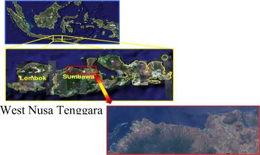
North Coastal Area of
Fig. 1 Research Location in North Coastal Area of Sumbawa Regency (JAXA, 2006)
The research carried out for 10 months (July 2008-Apryl 2009). The research done in 4 steps there were (1) Collecting data; (2) Processing data, consisted of a) preliminary step of image processing such as conversion image to raster file, image cropping, geometric correction, radiometric correction using Abrams and Hook method (2002), and image masking process, b) Water column correction using Lyzenga method (1981) and applying in each combinations of visible band (type 1 consist of band 1 and band 2 combination, type 2 consist of band 2 and band 3 combination, and type 3 consist of band 1 and band 3 combination), c) Multispectral classification process, (3) Field surveys; and (4) Accuracy test of image classification 46
using Lillesand and Kiefer method (1990). Image ALOS satellite with AVNIR-2 sensor. The recorded result of September 26th 2006, with identity scene of ALAV2A035013770. There were 4 bands (Table 1) and it is already corrected in 1BR level.
Table 1. Description of ALOS Satellite with AVNIR-2 Sensor
|
Band |
Wavelength (µm) |
Position |
|
1 |
0.42-0.50 |
visible blue |
|
2 |
0.52-0.60 |
visible green |
|
3 |
0.61-0.69 |
visible red |
|
4 |
0.76-0.89 |
near infrared |
(JAXA, 2007).
RESULT AND DISCUSSION
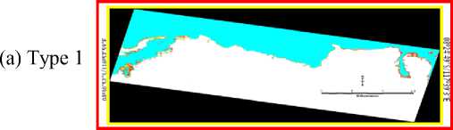
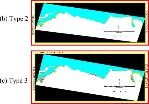
Fig. 2. Image after multispectral classifications process at each combinations bands (a) Type 1, (b) Type 2, and (c) Type 3. Describes the separation amount coral (red), hard sand and rubble coral (yellow), soft sand (cream), substratum (grey), seagrass (clear green), and seaweed (dark green).
According to Lyzenga (1981), Lyzenga method used to get a better visual image for under water object (benthic object), in this case benthic object including marine plants. According to Mumby et al. (1998), the accuracy of benthic object map was increasing by water column correction process using Lyzenga method. Atkinson and Hochberg (2003) showed the wavelength of marine plants using the satellite sensor were 0.47-0.66 µm, the band 1 and the band 2 in ALOS/AVNIR-2 data were from 0.42 µm to 0.50 µm and from 0.52 µm to 0.60 µm. Thus, the image type 1 gave better the visual object benthic than another combination of bands (type 2 and type 3) the accuracy for type 1 was 86.667 %, the standard detail level of marine plants
ecosystem mapping by interpretation of satellite image which could be accepted not less in the overall accuracy is 75%.
Table 2. Classification error matrices for field surveys spectral reflectance of six benthic object: coral, hard sand and rubble coral, soft sand, substratum, seagrass and seaweed.
|
(a) Type 1: overall accuracy = 86.667 % | ||||||||
|
Field Surveys | ||||||||
|
Coral |
Hard Sand and Rubble Coral |
Soft Sand |
Sub-stratum |
Seagrass |
Seaweeds |
Total | ||
|
3 SΛ V Ctf S & .S S S o 5» SΛ U |
Coral |
46 |
3 |
1 |
1 |
2 |
2 |
55 |
|
Hard Sand and Rubble Coral |
1 |
33 |
2 |
2 |
1 |
0 |
39 | |
|
Soft Sand |
0 |
3 |
36 |
1 |
0 |
0 |
40 | |
|
Substratum |
1 |
2 |
1 |
36 |
1 |
0 |
41 | |
|
Seagrass |
4 |
0 |
1 |
0 |
40 |
2 |
47 | |
|
Seaweeds |
1 |
0 |
0 |
0 |
2 |
30 |
33 | |
|
Total |
53 |
41 |
41 |
40 |
46 |
34 |
255 | |
(b) Type 2: overall accuracy = 56.471%
|
Field Surveys | ||||||||
|
Coral |
Hard Sand and Rubble Coral |
Soft Sand |
Sub-stratum |
Seagrass |
Seaweeds |
Total | ||
|
3 ⅛ |
Coral |
35 |
1 |
1 |
1 |
9 |
5 |
52 |
|
Hard Sand and Rubble Coral |
1 |
37 |
1 |
0 |
26 |
18 |
83 | |
|
S β .≡ S S o CΛ CS U |
Soft Sand |
1 |
1 |
37 |
1 |
6 |
5 |
51 |
|
Substratum |
0 |
0 |
1 |
35 |
5 |
4 |
45 | |
|
Seagrass |
8 |
1 |
1 |
1 |
0 |
2 |
13 | |
|
Seaweeds |
8 |
1 |
0 |
2 |
0 |
0 |
11 | |
|
Total |
53 |
41 |
41 |
40 |
46 |
34 |
255 | |
|
(c) Type 3: overall accuracy = 63.529% | ||||||||
|
Field Surveys | ||||||||
|
Coral |
Hard Sand and Rubble Coral |
Soft Sand |
Sub-tra-tum |
Seagrass |
Seaweeds |
Total | ||
|
Q «e |
Coral |
46 |
1 |
0 |
0 |
11 |
17 |
75 |
|
Hard Sand and Rubble Coral |
1 |
38 |
1 |
0 |
6 |
2 |
48 | |
|
Soft Sand |
1 |
0 |
39 |
0 |
4 |
5 |
49 | |
|
Substratum |
0 |
0 |
0 |
39 |
5 |
4 |
48 | |
|
Seagrass |
3 |
1 |
1 |
1 |
0 |
6 |
12 | |
|
Seaweeds |
2 |
1 |
0 |
0 |
20 |
0 |
23 | |
|
Total |
53 |
41 |
41 |
40 |
46 |
34 |
255 | |
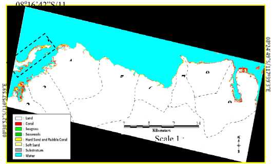
Table 3 showed the distribution of benthic objects in each district. The high distribution of seagrass in Moyo Hilir district was 285.44 hectares, (Figure 4). On the other hand Moyo Hilir district was 109.74 hectares of seaweeds. Because of the location of Moyo Hilir district was located by some bays (Prajak, Palabanang, Aipapang, Aiburu, Labuhanijuk, Subawi, Boea Besar, Boea Kecil, Saning, Aigayong, Aideras bays), thus they are located far from big wave which can destroy the root and disturb the growth of marine plants because there were some bays as barrier for big wave passing.
08o38’59”S/
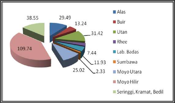
Fig. 4. Distributions of seagrass (ha) in each district of Sumbawa regency
Fig. 3. General distribution of marine plants using type 1 image. The separation 9 districts location amount 1) Kramat, Bedil and Seringgi islands, 2) Alas, 3) Buir, 4) Utan, 5) Rhee, 6) Labuan badas, 7) Sumbawa, 8) Moyo utara, and 9) Moyo hilir.
Table 3. Distribution of benthic objects in each districts
|
No |
Class |
Area (in hectares) | |||||||||
|
Seringgi, Keramat, Bedil Islands |
Alas |
Buir |
Utan |
Rhee |
Labuan Badas |
Sumbawa |
Moyo Utara |
Moyo Hilir |
Σ | ||
|
1 |
Coral |
215.44 |
204.82 |
44.28 |
164.01 |
23.04 |
38.45 |
14.67 |
119.12 |
297.29 |
1121.12 |
|
2 |
Hard sand and rubble coral |
285.21 |
190.29 |
17.97 |
236.57 |
46.58 |
73.76 |
57.86 |
203.84 |
102.53 |
1214.61 |
|
3 |
Soft sand |
202.84 |
134.99 |
74.64 |
195.31 |
37.6 |
52.82 |
5.56 |
95.04 |
254.72 |
1053.52 |
|
4 |
Substrarun |
135.65 |
133.12 |
50.14 |
129.39 |
17.78 |
35.12 |
8.76 |
112.51 |
401.58 |
1024.05 |
|
5 |
Seagrass |
122.96 |
160.95 |
42.89 |
115.13 |
15.36 |
24.52 |
6.3 |
61.82 |
285.44 |
835.37 |
|
6 |
Seaweeds |
38.55 |
29.49 |
13.24 |
31.42 |
7.44 |
11.93 |
2.33 |
25.02 |
109.74 |
269.16 |
Generally, the north coastal area of Sumbawa regency was dominated by hard sand and rubble coral (Figure 6). The hard sand and rubble coral was 1214.61 ha (22%)and followed by coral was 1121.12 ha (20%), substratum and soft sand were each 1024.05 ha (19%), seagrass was 835.37 ha (15%), and seaweeds was 269.16 ha (5%). The hard sand and rubble coral were dominant in that area because the north coastal area of Sumbawa regency stands opposite Flores Sea.
The wave of Flores Sea bringing sediment of substrate, the coastal was suspended the sediment. Sediment quality, depth and mobility are important factors for marine plants composition, growth and persistence.
Most marine plants live in sand and mud substrates where their rhizome and holdfast anchor the plants to the sea floor. Some seagrasses such as the Cymodocea prefer deeper sediments while others can tolerant a broad range of sediment depths. The biogeochemical characteristics of sediment can affect the nutrient contents, organic content and oxygen levels.
Generally, the total values (hectare) of marine plants (seagrass and seaweed) were less than the hard sand and rubble coral or another benthic in the area because the human activities can damage or destroy the marine plants meadows. Coastal development for tourism boat marinas,
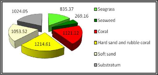
Fig. 5. Distributions of seaweeds (ha) in each district of Sumbawa regency
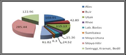
Fig. 6. Distributions of benthic object (ha) in north coastal area of Sumbawa regency.
shipping ports and housing on the coast in the areas which were sheltered and marine plants like grow. Marine plans
meadows were removed or buried by these activities. Coastal developments can also cause the changes in water movement. The channels of boat in the sea can provide access to the change in water movement not only physically removes plants also the channels can make the water muddy and dump sediment on marine plants.
Comparison between Moyo Hilir district and Labuan Badas district (Figure 3) were seagrass was 285.44 hectares and seaweed was 109.74 hectares in Moyo Hilir district but in the Labuan Badas district seagrass was 24.52 hectare and seaweed was 11.93 hectares. Although the Labuan Badas district and the Moyo Hilir district have the almost, same temperature (from 30.9oC to 32.1oC) but the Labuan Badas district water was stand opposite Flores Sea which the wave of Flores Sea can break and bring the sediment from the coastal to the sea and back again to the coastal. The conditions in Labuan Badas water more seriously by Badas harbor in the area because the oil spill and the trace metal from the ships can contamination and propagation the toxic affects directly on marine plants species so the marine plants cannot grow better.
The contamination of oil spill in sea water can effect kilt the marine plants meadows and causing the blankness of marine plants habitat in the area. Thus, the impact of the condition was decreased of the value of seagrass and seaweed in Labuan Badas districts than Moyo Hilir district. Mellors and McKenzie (2009) showed marine plants were able to bioaccumulate (bioaccumulate mean the toxic is added at a rate higher than originally present in the environment) the toxic from oil spill and trace metal. The condition has implications for grazers such as Dugong dugon and turtles.
The different with the Labuan Badas district, the Moyo Hilir water was in central of the island (see Figure 3) and the Moyo Hilir water was stand opposite the Saleh bay and Moyo island so the area was protected from big wave of Flores Sea which can break and bring the sediment into coastal. Shallow wave in Moyo Hilir district can support the conditions of marine plants life and the coral reefs in the area were as barrier for the big wave.
The general species of marine plants in north coastal area of Sumbawa regency characterized four species of seagrass (Cymodocea rotundata, Enhalus acoroides, Syringodium isoetifolium, and Halophila ovalis) and five species of seaweed (Euchema cottoni ssp sakul, Halimeda sp, Sargasum duplicatum, Euchema cottoni, and Padina sp) in the area because the general conditions in north coastal area of Sumbawa regency consist of shallow reef flats, intertidal subtidal depths sand, mud banks (often adjacent to mangrove forests), subtidal reef flats and sand banks. The rhizome and the holdfast (name of marine plant’s root) can stick and bind the substrate, sand and mud bank. The shallow reef flats as barrier for the wave can destroy the roots of marine plants and disturb the growth of marine plants, so the condition can support the their life place for that species.
The maximum temperatures in the area were 30.9o-32.1oC (DKP-NTB, 2007) which can support to grow of marine plants, but the rate of photorespiration increases reducing the efficiency of photosynthesis over 38oC. Mellors and McKenzie (2009) showed the temperatures from 38oC to 42oC cause the cell responsible for photosynthesis to shut down and many plant proteins were simply destroyed resulting in plant death. In contrast to land plants, some marine plants can survive in a range of conditions encompassing fresh water, estuarine, marine, or hypersaline (very salt conditions). The salinity in north coastal area of Sumbawa regency was 35 o/oo (DKP-NTB, 2007), the salinity was support of marine plants grow best.
CONCLUSIONS AND SUGGESTIONS Conclusion
The result conclusions were:
-
1. Lyzenga method is employed to ALOS/AVNIR-2 data to detect the marine plants distributions because the data has 3 bands which penetrate into water. The accuracy of benthic object map was increased by approach the method for multispectral classification.
-
2. For AVNIR-2 case, the combinations of band 1 and band 2, the wavelength of (0.42 - 0.60 µm) is the best
combination to detect marine plants distributions using the Lyzenga method, with the level accuracy equal to 86.67 %.
-
3. The general species of marine plants in north coastal area of Sumbawa regency were four species of seagrass (Cymodocea rotundata, Enhalus acoroides, Syringodium isoetifolium, and Halophila ovalis) with the area was 835.37 ha, while seaweeds were found equal to five species (Euchema cottoni, Euchema cottoni ssp sakul, Halimeda sp, Padina sp, and Sargasum duplicatum) with the area was 269,16 ha.
Suggestion
Based on the result of this research, the author can be suggested as follows:
-
1. To use water column correction (Lyzenga method) in multispectral classification process can make easy to separate the benthic object,
-
2. It is necessary to continue the research using satellite data to estimate the change of marine plants distribution in every year in the area.
-
3. To the government of Sumbawa regency, Moyo Hilir water is the best location in north coastal area of Sumbawa regency to develop the aquaculture of marine plant (seaweeds) because the position of the area more conducive such as the low current, temperature 30.9o – 32.1oC, dominant by subtidal reef flats and sand banks.
REFERENCES
Abrams, M. and Hook, S. 2002. ASTER User Handbook Version 2. California: Jet Propulsion Laboratory, California Institute of Technology. p. 1-135.
Atkinson, M. J. and Hochberg, E. J. 2003. Capability of Remote Sensors to classify coral, algae, and sand as pure and mixed spectra. Remote Sensing of Environment Journal 85: 174-189.
Dinas Perikanan dan Kelautan Provinsi Nusa Tenggara Barat (DKP-NTB). 2007. Buku Data Informasi Pokok Perikanan dan Kelautan NTB 2007. Mataram: DKP Provinsi NTB. p. 27-29, 49, 53, 72-74.
Dinas Perikanan dan Kelautan Provinsi Nusa Tenggara Barat (DKP-NTB). 2007. Profil Wilayah Pesisir dan Lautan Propinsi NTB. (serial online), [Cited 2008 July 8th]. Available from http://diskanlut.ntb.go.id/web/content/view/36/48/.
Herricks, E. E. and Cairns, J. Jr. 1982. Biological Monitoring Part III-Receiving System Methodology Based on Community Structure. Water research 16 : 141-153.
Holden, H and LeDrew, E. 1998. The Scientific Issues Surrounding Remote Detection of Submerged Coral Ecosystems. In Spatial Distribution of Benthic Microalgae on Coral Reefs Determined by Remote Sensing (eds). 1999. Queensland: Department of Botany, The University of Queensland. p. 1-32.
Japan Aerospace Exploration Agency (JAXA). 2006. AVNIR-2 Data with identity scene of ALAV2A035013770. Japan: JAXA.
Japan Aerospace Exploration Agency (JAXA). 2007. ALOS Satellite Data. (serial online), [Cited 2008 April 13rd]. Available from http://dmss.tksc.jaxa.jp/sentirel/.
Japan Aerospace Exploration Agency- Earth Observation Research Center (JAXA-EORC). 2008. ALOS Research Announcement-Main Body Earth. Observation Research Center, Japan. JAXA EORC. (serial online), [Cited 2008 April 13rd]. Available from
http://www.eorc.jaxa.jp/ALOS/ra/ral_body.htm.
Lerman, M. 1986. Marine Biology. Menlo Park: The Benjamin/Cumming Publishing Company inc. p. 39.
Lillesand, T. M. and Kiefer, R. W. 1990. Remote Sensing and Image Interpretation. (Dulbahri, et al., Translator). Yogyakarta: Gadjah Mada University Press.
Lyzenga, D. R. 1981. Remote Sensing of Bottom Reflectance and Water Attenuation Parameters in Shallow Water Using Aircraft and Landsat Data. International Journal Remote Sensing 2 : 71-82.
Mellors, J. and McKenzie, L. 2009. Seagrass watch: Guidelines for monitoring seagrass habitats in the Torres strait. Queensland: Department of Primary Industries and
Fisheries.
Mumby, P. J., Clarl, C. D., Green E. P. and Edwards, A. J. 1998. Benefits of Water Column Correction and Contextual Editing for Mapping Coral Reefs. International Journal Remote Sensing 19 : 203-210.
Mumby, P. J. and Green, E. P. 2000. Mapping Seagrass Bed in Remote Sensing Handbook for Tropical Coastal Management. France: United Nations Educational
Scientific and Cultural Organization. p. 175-181.
Nurdin, E. 2000. Potensi Pengembangan Perikanan di Situ Pondok Cina. Indonesia University. Depok. Makara: Journal of Research Indonesia University 7 B : 1-10.
Toni, 2006. Inventarisasi Jenis Makroalga di Pulau Sertung dan Pulau Sebesi, Selat Sunda, Lampung, Work Research Report. Jakarta: Indonesia University Press. p. 2-3.
World Conservation Monitoring Centre (WCMC). 2001. Distribution of Coral, Mangrove and Seagrass Diversity. (serial online), [Cited 2008 July 14th]. Available from http://maps.grida.no/go/graphic/distribution_of_coral_ma ngrove_and_seagrass_diversity.
Wikipedia, 2006. Provinsi Nusa Tenggara Barat. (serial online), [Cited 2008 June 4th]. Available from
http://id.wikipedia.org/wiki/Provinsi_Nusa_Tenggara_Ba rat.
50
Discussion and feedback