Augmented Reality Application with Real Object Marker of Tanah Lot Temple
on
JURNAL ILMIAH MERPATI VOL. 9, NO. 1 APRIL 2021 p-ISSN: 2252-3006
e-ISSN: 2685-2411
Augmented Reality Application with Real Object Marker of Tanah Lot Temple
I Putu Yoga Pertama Yasaa1, I Ketut Gede Darma Putra a2, Dewa Made Sri Arsa a3 aDepartment of Information Technology, Faculty of Engineering, Udayana University
Bukit Jimbaran, Bali, Indonesia, telp. (0361) 701806
e-mail:1yoga.pertama@student.unud.ac.id, 2ikgdarmaputra@unud.ac.id, 3dewamsa@unud.ac.id
Abstrak
Pura Tanah Lot terletak di Desa Beraban, Kecamatan Kediri, Kabupaten Tabanan. Pura Tanah Lot merupakan Pura yang termasuk ke dalam Pura Dang Kahyangan. Pura Tanah Lot memiliki bangunan yang tersebar di Obyek Wisata Pura Tanah Lot. Bangunan yang terdapat di Pura Tanah Lot tidak semua informasinya diketahui oleh wisatawan. Augmented Reality merupakan sebuah teknologi visual yang menggabungkan objek atau dunia virtual ke dalam tampilan dunia nyata secara real time. Penelitian ini menggunakan metode markerless dan dikembangkan menggunakan library Wikitude serta didukung dengan web hosting untuk menyimpan data informasi dan data koordinat bangunan. Sistem dalam penelitian ini berjalan secara dinamis, sehingga memudahkan dalam memanajemen data tanpa harus memodifikasi kode program. Hasil aplikasi Augmented Reality dengan marker obyek nyata Pura Tanah Lot ini adalah dapat menampilkan informasi berupa narasi teks dan poin lokasi beserta suara penjelasan masing-masing bangunan yang terdapat di Pura Tanah Lot.
Kata kunci: Augmented Reality, Markerless, Wikitude, Obyek Nyata, Pura Tanah Lot
Abstract
Tanah Lot Temple is located in Beraban Village, Kediri District, Tabanan Regency. Tanah Lot Temple is a temple that is included in the Dang Kahyangan Temple. Tanah Lot Temple has buildings scattered in the Tanah Lot Temple Tourism Object. Not all of the buildings in Tanah Lot Temple are known by tourists. Augmented Reality is a visual technology that combines objects or virtual worlds into real-world views in real-time. This study used markerless method and was developed using the Wikitude library and supported by web hosting to store information data and building coordinate data. The system in this study runs dynamically, making it easier to manage data without modifying the program code. Augmented Reality application results with real object marker of Tanah Lot Temple are that it can display information in the form of text narrative and location points along with voice explanations for each building in Tanah Lot Temple.
Keywords: Augmented Reality, Markerless, Wikitude, Real Object, Tanah Lot Temple
Bali Island is an island known as the Island of the Gods or the Island of a Thousand Temples. The existence of temples in Bali is an attraction for tourists worldwide, thanks to its uniqueness and beauty. [1] One of the potential and development of Bali Island is in the tourism industry, one of which is the Tanah Lot Temple Tourism Object, which is located in Beraban Village, Kediri District, Tabanan Regency.
Tanah Lot Temple offers uniqueness and beauty for tourists, including the temple building built on a boulder in the middle of the sea. The beauty of the sunset adds to the attraction of tourists visiting Tanah Lot Temple. Many tourists visit Tanah Lot Temple Tourism Object to see the uniqueness or want to take pictures in front of the building. Still, many of these tourists also do not know information about the building's name, layout, and function.
Based on these problems, a technology-based information and communication media is needed that is able to explain and provide information about building information and building layout in Tanah Lot Temple to domestic and foreign tourists with a complete and attractive
presentation of information. AR (Augmented Reality) is currently experiencing rapid development, where Augmented Reality technology has touched various areas of life, especially in advertising, education, and tourism.
Research on the application of Augmented Reality in various fields has been carried out, one of which is the research by Adi Ferliyanto Waruwu in 2014. This research discusses AR technology as a medium for providing information about Temple in Bali. DewataAR uses Android as a platform and is designed using the Vuforia SDK to produce applications that can display 3D objects, the information in audio and video. [2]
Another research is a study by I Ketut Gede Darma Putra in 2019, which discusses Augmented Reality in the field of education. This research uses books as markers. The final result of this research is the augmented reality application that displays 3D objects and the appropriate music so that reading Lubdaka folklore is more enjoyable. [3]
Augmented Reality application in the introduction of objects in the form of buildings has been carried out in research by Anak Agung Ngurah Hary Susila and Dewa Made Sri Arsa in 2019. The research discusses augmented reality technology as building introduction media in Penglipuran Traditional Village, in this study using the Vuforia library and brochures as markers. The final result of this research is designing an augmented reality application that can provide information about the traditional buildings of Penglipuran Village in the form of 3D animation, text, and audio narratives. [4]
Augmented Reality's application and implementation in this study touch the field of tourism and education on promoting and presenting Tanah Lot Temple to tourists in an attractive form using a smartphone or tablet. This research is designed to use the Wikitude library on Android smartphone devices and web hosting to store application data so that the system in this study is dynamic.
The Augmented Reality application with real object markers of Tanah Lot Temple produces output in the form of 2D objects of building information and location points and is clarified with audio explanations of each building's details. The use of the method of presenting information with Augmented Reality technology is expected to be more attractive to tourists and facilitate and pamper tourists in knowing building information at Tanah Lot Temple by giving more attractive information.
The method used in application design uses the waterfall method, where the stages are carried out in four stages, namely the stages of analysis, design, implementation, and testing. Research data collection is the initial stage carried out. Sources of research data are obtained from scientific journals, books, ebooks, official websites, and published papers downloaded via the internet. The method used in this study is the Markerless Method.
The markerless method is a method in augmented reality, wherein this method users no longer need to use a marker to display digital elements. Even though it is called markerless, the application is run by scanning objects or markers, but the scanned scope is more comprehensive than conventional augmented reality markers.
In the design stage, a design is carried out to describe an overview of the system, use case diagrams, design the application display design, and website display design. In the coding stage, the application is made using JavaScript, Java, HTML, and PHP. The programming languages Javascript, Java, HTML, and PHP, were chosen because they are compatible with the Android Studio and Wikitude programs for developing Augmented Reality Applications.
In the testing phase, detection testing was carried out using several smartphone devices with different light intensity conditions to determine the application's success rate in identifying and displaying object information with different device specifications and conditions.
The system overview displays the interaction process that occurs between the device and the user. With an overview of the system, it is expected that users can easily understand using the system and applications. An overview of the Augmented Reality application system with the real object marker of Tanah Lot Temple is shown in Figure 1.
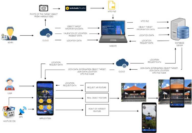
Figure 1. System Overview
Figure 1 is an overview of the system starting from the preparation, manufacture, and use of the augmented reality application with real object markers of Tanah Lot Temple. There are two entities in the system overview: Admin and User. Admin has a function to process and manage data to be inputted into the application. The first stage begins with the admin searching for information data and taking photos of buildings from various sides that will be used as target objects, then the admin can upload the building images to the Wikitude studio, at the Wikitude studio the building drawings are processed into target objects in the form of wto files.
The wto file that is obtained can be uploaded on the website to proceed to the next process. In the next process, the admin inputs data in the form of text, information on the target object and location data on the website. The data will be stored on the database server and encoded into JSON. JSON data and WTO file name is sent to the application to make it easier for the application to scan data and display information to the user.
The system overview also shows the interactions that occur between the user and the application. Users can interact directly with an Android smartphone equipped with an Augmented Reality application with a real object marker for Tanah Lot Temple, supported by the Wikitude library. First-time users can activate the cellular data network and GPS for easy operation of the app. Users can select features available in the application, such as real object features, point of interest features, and AR request features.
The output obtained by users is different for each feature. Real object features allow users to directly interact with the application by pointing the Android smartphone towards the target object. The output displayed is information in the form of narrative text accompanied by an explanation of the target object's sound. Another result obtained by the user is that the application can display location points around the area if users select the point of interest feature. Users can request a specific location to be displayed on the application by selecting the request ar feature. With the various features contained in the application, it is hoped that it can make it easier for users to find out the information contained in the Tanah Lot Temple Tourism Object.
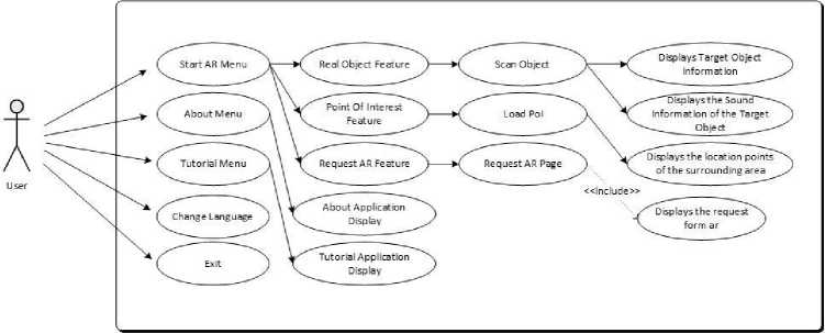
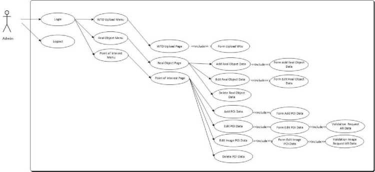
Use case diagrams are used to describe the interactions that can occur between users and systems and applications. The use case diagram in this study is divided into two: the user use case diagram and the admin use case diagram.
(a)
(b)
Figure 2. (a) User Use Case Diagram. (b) Admin Use Case Diagram
Figure 2 (a) illustrates the features and menus that the user can use to detect, display information, find out how to use and develop the application and exit the application. Features that can be run by users in the application are on the AR Start menu, namely the Real Object feature, the Point of Interest feature and the AR Request feature. Figure 2 (b) illustrates the interaction that occurs between the system and the admin. Admins can use a use case designed to perform data management by utilizing the menus and forms contained in the system.
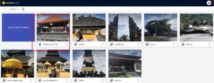
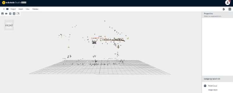
Creating the target object in Wikitude Studio is by uploading a building image from various sides to the Wikitude studio. The process of creating the target object in Wikitude Studio can be seen in Figure 3.
(a)
(b)
Figure 3. (a) Target Object added successfully. (b) Result of Create Object Target
Figure 3 (a) shows the target object creation process in Wikitude Studio. In this study, the target object used was the construction of the Bale Gong Tanah Lot Temple. Figure 3 (b) shows the results of the target object creation process in Wikitude Studio, which produces a point cloud that can be downloaded in the form of a wto file. This wto file serves to track and identify and display information about the target object based on requests from the application.
The literature review is a supporting theory presentation which becomes the primary reference in designing Augmented Reality applications with Tanah Lot Temple real object marker.
Tanah Lot Temple is geographically located in Beraban Village, Kediri District, Tabanan Regency. Tanah Lot Temple offers uniqueness and beauty for tourists, including the temple building, which is built on a rocky rock in the middle of the sea, and the beauty of the sunset, which adds to tourists' attraction to visit Tanah Lot Temple [5]. Tanah Lot Temple has located about 13 km from Tabanan and 22 km from the city of Denpasar. The area within the area of the Tanah Lot Tourism Destination area, there are several temples, namely Tanah Lot Temple, Penyawangan Temple, Jero Kandang Temple, Enjung Galuh Temple, Batu Bolong Temple, Batu Mejan Temple, Pakendungan Temple.[6]
Augmented Reality (AR) is one of the innovations that arise from technological developments. Augmented Reality is a technology that can make two-dimensional and threedimensional objects appear to be in the real world and interact with humans. Augmented reality technology helps simplify real objects by carrying virtual objects so that all users can receive that information.[7] Augmented Reality has two methods for identifying markers, namely markerbased tracking and markerless. Marker-based tracking is a technique that gives commands to a computer to track markers that have been created and placed in their proper positions. The markerless method is different from marker-based tracking, which does not require a marker to trigger the object's appearance. Research that applies the markerless approach in his study is found in a study conducted by I Wayan Andis Indrawan in 2017. [8]
Wikitude is a software development kit that can build, maintain, and monitor Augmented Reality environments. Wikitude in 2008 included image recognition, 3D model rendering, location-based AR, and SLAM (Simultaneous Localization and Mapping) technology that allows object recognition and object tracking without the need for markers. The Wikitude SDK features the Wikitude Studio, a website-based studio designed to produce and manage the Wikitude Image Collection (wtc) and Wikitude Object Collection (wto) and create and publish augmented reality experiences. Wikitude uses commonly used programming languages, such as
JavaScript, HTML5, and CSS3. Wikitude first released the Software Development Kit (SDK) in 2008. Wikitude SDK can run on Android and IOS operating systems.[9]
Android is an operating system that runs on smartphones. Android provides an open platform (open source) for application developers to create various kinds of applications. The origin of Android occurred when Google Inc. bought shares of Android Inc., a newcomer who made software (software) for mobile phones. Then Android developed and formed the Open Handset Alliance, a combination of 344 hardware, software, and telecommunications companies including Google HTC, Intel, Motorola, Qualcomm, TMobile, and Nvidia. [10]
Results and discussion describe the results of the research discussion carried out, both in terms of appearance, use, and testing of systems and applications. This study produces two views, namely the website and application. The admin uses the website in this study to manage the data that will be entered into the application, and users can use the application to get the information contained in Tanah Lot Temple.
The system implemented in this study is dynamic. A dynamic system is a system that makes it easy to add new information without having to change the program code, and this can be seen in this study using the website to manage data. The admin uses the website in this study to collect data that will be entered into the application. The website can make it easier for admins to manage data that will be displayed on the application. In managing data in this study, the admin can use the wto upload page, real object page, and point of interest page contained on the augmented reality website page with real object markers of Tanah Lot Temple.
The wto upload page functions for the admin to upload the wto files obtained from Wikitude Studio. Figure 4 displays the wto upload page on the Tanah Lot Temple augmented reality website page.
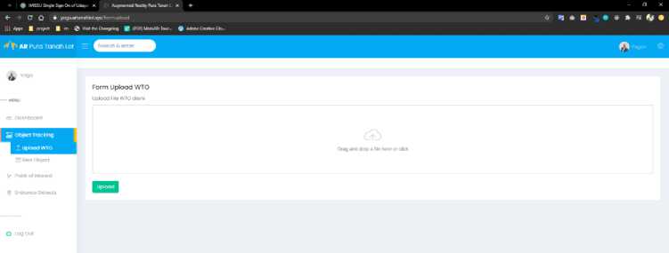
Figure 4. Upload WTO Page
Figure 4 shows the upload wto page of the Tanah Lot Temple augmented reality. Using the wto upload page, the admin can drag or click the form to add the wto file to the upload form. After the wto file is successfully added, the admin can select the upload button to upload the wto file.
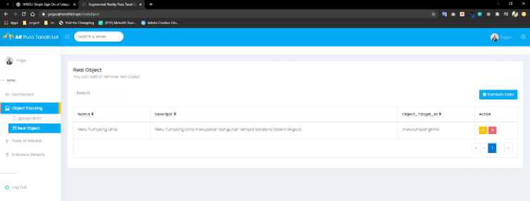
The real-object page serves to add a description of the explanation information on the target object. The real-object page is a page that must be filled in by the admin after the WTO file upload process is successful. Admin can add data, edit data, or delete data on the real object page. Figure 5 is a display of real object pages on the Tanah Lot Temple augmented reality website.
(a)

(b)
Figure 5. (a) View Data Form, (b) Add Data Form
Figure 5 shows a real object page on the Tanah Lot Temple augmented reality website. The real object page is a page view used by the admin to process and manage the target object data sent to the application. Figure 5 (a) shows the view data on the real object page. Admin can add data by using the add data button provided. Figure 5 (b) displays the add data form on the real object page. Admin can add data Name, Description, Object Target Id. Admin can add data names and descriptions to display English information on the application. The naming of the target id object on the real object page must match the target object's name in Wikitude Studio, as shown in Figure 3 (a). With the appropriate naming, the application can easily detect and display information.
The point of interest page is the page that is displayed when the admin selects the point of interest menu. Figure 6 is a point of interest page view of the Tanah Lot Temple augmented reality website

Figure 6. Point of Interest Page
Figure 6 displays a point of interest page on the Tanah Lot Temple augmented reality website. The point of interest page is an admin page for processing and managing location coordinate data information displayed in the point of interest application feature. Location coordinate data is obtained from latitude and longitude values. AR request data from the user will be received on the point of interest page. Admin can validate the request data entered by the user by changing the request status value.
The status on the point of interest page functions to display the validation status of the location data displayed on the application. A status value of 1 means the data is displayed on the application, and if the status value is 0, the information is not displayed on the application.
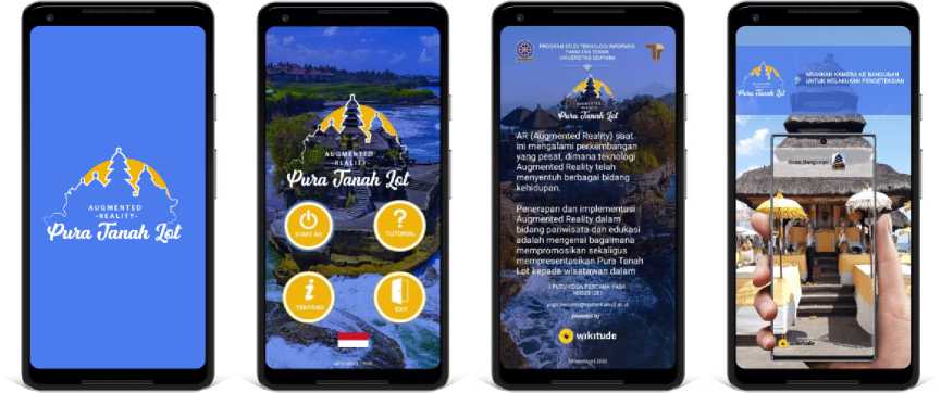
The application in this research is based on android to make users feel comfortable and easy to use. The Augmented Reality application interface with Tanah Lot Temple real object markers includes a splash screen page display, main menu display, about application page display, and application tutorial page display.
(a) (b) (c) (d)
Figure 7. (a) Splash Screen Display, (b) Main Menu Display, (c) About Application Page Display, (d) Application Tutorial Page Display
Figure 7 shows the Augmented Reality application's appearance with the real object marker of Tanah Lot Temple. Figure 7 (a) shows the splash screen page with the application logo. Figure 7 (b) displays the application's main menu page. Users can choose four menus available on the main menu page, namely AR Start Menu, About Menu, Tutorial Menu, and Exit Menu. Users can also change the language by pressing the flag icon in the main menu of the application. Figure 7 (c) displays a page about the application that contains information about the application developer. Figure 7 (d) shows a tutorial page that includes an explanation of using the augmented reality application with real object marker of Tanah Lot Temple.
The Augmented Reality application with the Tanah Lot Temple real object marker has the main feature, namely the real object feature. There are also additional features in the augmented reality application with this Tanah Lot Temple real object marker, namely the point of interest feature, the AR request feature, and the language change feature.
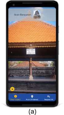
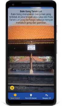
The real object feature displays the augmented reality camera used to detect the target object. The real object feature in the augmented reality application with the Tanah Lot Temple real object marker can be seen in Figure 8.
(b)
Figure 8. (a) Conditions before the target object is detected successfully, (b) Display Target Object Information after successfully detected
Figure 8 shows the real object features in the augmented reality application with the Tanah Lot Temple real object marker. Using the real object feature, the user can interact directly by pointing the smartphone camera at the building where the information is wanted. The output that the user gets is information along with text narration and voice explanation of building information that is displayed directly on the user's smartphone.
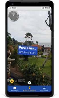
The point of interest feature is an additional feature that displays an augmented reality camera used to display location points. The point of interest feature in the augmented reality application with the real object marker of Tanah Lot Temple can be seen in Figure 9.
(a)

(b)
Figure 9. (a) Display of Location Points, (b) Detail of Location Points
Figure 9 shows the point of interest feature in the augmented reality application with the real object marker of Tanah Lot Temple. Using the point of interest feature, users can interact directly by directing the smartphone device to the surrounding area. Users will get information in the form of location points that are displayed directly on the smartphone device. Users can press location points to get detailed information about the location points.
The AR request feature is an additional feature in this study. With the AR request feature, the user is redirected to the AR request website page to fill out a form that will be sent
to the admin for the validation process. The AR request feature in the augmented reality application with the Tanah Lot Temple real object marker can be seen in Figure 10.
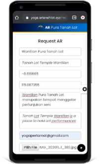
Figure 10. Request AR Feature
Figure 10 shows the AR request feature. Using the AR request feature, the user can input data on the available form. Data that has been successfully entered in the AR request feature is sent to the point of interest website page for further data validation by the admin.
The testing process for the Augmented Reality Application with Tanah Lot Temple real object markers uses two Android smartphone devices that have different specifications in terms of processor performance, screen size, GPU, and RAM capacity. The Android smartphone devices used are Redmi and Vivo. The test process is carried out in day and afternoon conditions. The results of smartphone testing can be seen in Table 1.
Table 1. Test Results
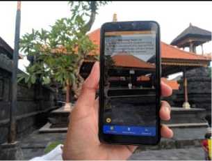
Figure 11. Test Results on Redmi with Daytime conditions
Daytime
Information
Figure 11 shows the results of the Redmi device with daytime conditions that can detect and display target object information completely and correctly with a distance of 15 meters and with a time of 10 seconds.
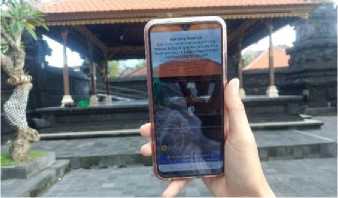
Figure 12. Test Results on Vivo with Daytime conditions
Figure 12 shows Vivo devices' results with daytime conditions that can detect and display target object information completely and correctly with a distance of 10 meters and within 5 seconds.
Afternoon
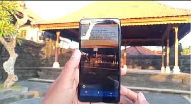
Figure 13. Test Results on Redmi with Afternoon conditions
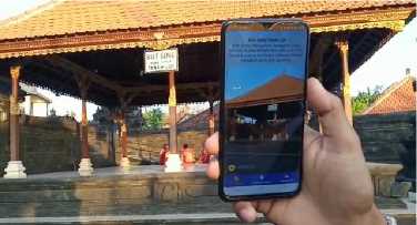
Figure 14. Test Results on Vivo with Afternoon conditions
Figure 13 shows the results of the Redmi device with afternoon conditions that can still detect and display target object information completely and correctly with a distance of 10 meters and with a time of 15 seconds.
Figure 14 shows the results of Vivo devices with afternoon conditions that can still detect and display target object information completely and correctly with a distance of 8 meters and with a time of 12 seconds.
Table 1 is the test result of each device in the daytime and afternoon conditions. The application testing process is carried out to determine the Wikitude system's accuracy and each device's system. The test results with daytime conditions on each device show very good results and fast detection time. This is because there is sufficient light in daytime conditions so that the target object detection process carried out by each device runs very well. Meanwhile, the testing process in the afternoon conditions showed quite good results. Testing with conditions in the afternoon, each device can still display information but a closer distance and longer time in the detection process. This is due to the minimal lighting obtained by the camera of each device for detection. Other factors that can affect the device in detecting the target object and displaying the location points are the shooting factor and each device's signal strength factor.
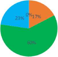
Application assessment is carried out by distributing a questionnaire of 25 sheets. There are six questions in the survey, each of which has grades 1-4 with information from less useful / less easy to very good / very easy. The results of the survey are illustrated with a diagram, which can be seen in Figure 15.
-
■ Poor IPrettyGood BGood BVeryGood
Figure 15. Survey Results Diagram
Based on the results of the survey value from 25 respondents consisting of 6 questions, the highest score was obtained at level 3 with a percentage of 60%, which means Good, then continued with level 4 with a percentage of 23%, which means Very Good, then continued with level 2 which has a percentage of 17% which is pretty good and the last level of the measurement scale level 1 gets a percentage value of 0% which is considered poor. The conclusion obtained from the survey value results shows that the highest assessment is at level 3, namely Good, with a percentage value of 60%.
Based on the tests that have been carried out, the results are in the form of conclusions from Augmented Reality Design research with the real object markers of Tanah Lot Temple. This study was designed using the Wikitude library on Android smartphone devices and web hosting to store application data. The Augmented Reality application with Tanah Lot Temple real object markers can be dynamically functioned, making it easier to add information without modifying the application program code. Overall the application runs well on Android devices and can recognize target objects and display data in various conditions. Application appraisal is done by distributing questionnaires containing six questions aimed at 25 respondents. The results of the assessment based on the questionnaire analysis carried out get a percentage value of 60% at level 3.
Acknowledgement
Thank you to the Department of Information Technology, Faculty of Engineering, Udayana University, and the Tanah Lot Tourist Destination Area for helping carry out this research.
Reference
-
[1] I. G. K. Widana, “Pemanfaatan Simbol Suci Hindu Dalam Industri Pariwisata Bali,” in
Dharmasmrti: Jurnal Ilmu Agama dan Kebudayaan, vol. 17, no. 1, 2017, pp. 102–110.
-
[2] A. B. Ferliyanto, Adi, Darma Putra, “Augmented Reality Mobile Application of Balinese
Hindu Temples : DewataAR,” MECS Press, no. January, pp. 59-66, 2015.
-
[3] I. K. G. Darma Putra, I. M. Suwija Putra, and I. N. Adi Triginarsa, “Augmented Reality
Mobile Application of Balinese Story: LubdakaAR,” Eur. J. IT Proj. Manag., 2019, doi: 10.1017/CBO9781107415324.004.
-
[4] A. A. N. H. Susila and D. M. S. Arsa, “Aplikasi Augmented Reality Pengenalan
Bangunan Adat Desa Penglipuran,” J. Media Inform. Budidarma, vol. 4, no. 3, p. 726, 2020, doi: 10.30865/mib.v4i3.2208.
-
[5] Dinas Kebudayaan Propinsi Daerah Tingkat I Bali, PURA TANAH LOT. 1993.
-
[6] L. S. Darmaningsih, C. P. Nyoman, G. Id. Mahendra, and M. W. A. Kesiman,
“Pengembangan Aplikasi Augmented Reality Book Pengenalan Tata Letak Bangunan dan Landscape Pura Tanah Lot,” J. Pendidik. Teknol. dan Kejuru., vol. 11, no. 2, Aug. 2014, doi: 10.23887/jptk.v11i2.4082.
-
[7] Azuma and Ronald T., A Survey of Augmented Reality. Presence: Teleoperators and
Virtual Environments, vol. 1. 1997.
-
[8] I. W. A. Indrawan, I. P. A. Bayupati, and D. P. S. Putri, “Aplikasi Markerless Augmented
Reality Dewata Nawa Sanga Berbasis Android,” J. Ilm. Merpati (Menara Penelit. Akad. Teknol. Informasi), vol. 5, no. 2, p. 34, 2017, doi: 10.24843/jim.2017.v05.i02.p04.
-
[9] Wikipedia, “Wikitude,” Wikipedia. 2014.
-
[10] L. Madden, Augmented Reality Browsers for Smartphones, no. 1. 2011.
Augmented Reality Application with Real Object Marker of Tanah Lot Temple (I Putu Yoga 57
Pertama Yasa)
Discussion and feedback