Comfort Of Pedestrian Roads In The City Of Singaraja An Assessment Of User Behavior
on
Journal of A Sustainable Global South, Vol. 6 No. 2, August 2022
43
Comfort of Pedestrian Roads in The City of Singaraja an Assessment of User Behavior
Kadek Putra Santika Narayana1, Ida Bagus Gde Wirawibawa2, I Gede Agung Diasana Putra3
Magister Architecture
Faculty of Engineering, Udayana University Denpasar, Bali putrasantika9414@gmail.com
Architecture Department
Faculty of Engineering, Udayana University Denpasar, Bali
Architecture Department
Faculty of Engineering, Udayana University Denpasar, Bali
Abstract This study focuses on the concept of pedestrian path arrangement in terms of physical and non-physical conditions as well as user behavior. The research was conducted in commercial areas on Jalan Ahmad Yani and Diponegoro in Singaraja City, based on the phenomenon of pedestrian paths that are currently experiencing a change of function. The research method used is a qualitative method using place-centered mapping techniques for data collection. The place-centered mapping technique is used for mapping the location of activities / pedestrian paths and user sketches in using pedestrian paths which results in the concept of structuring pedestrian paths. The results of this study indicate that the current pedestrian paths in Singaraja City are not in accordance with the behavior of its users due to physical conditions and the change in the function of the pedestrian paths by parking, trading and displaying merchandise. So the concept of structuring the comfort of the pedestrian path that is produced is in the form of a pedestrian lane that should not be obstructed by behavioral activities or other supporting facilities, the need to provide an on-street parking area, the need for attention in terms of the pavement material used on the pedestrian path to comply with standards and the need for additional leveling. as well as pedestrian pathway dividers.
Index Terms— Concept, Arrangement, Behavior, Pedestrian Path
Singaraja City is one of the cities located in Bali Province. This city in northern Bali with an area of 27.98 km2 with a population of 80,500 people (Central Bureau of Statistics, 2015) [1]. The number of residents in the city of Singaraja, which is increasing every year, affects aspects of community behavior that are increasingly diverse. The following behavior applies to facilities for private and group interests to interact with each other in several public places, so it needs to be balanced with adequate and appropriate public facilities, such as pedestrian path targets that are in accordance with the needs and behavior of pedestrians.
Judging from the speed, the walking mode has many advantages, namely the low speed so that it is advantageous because it can observe the environment (Iswanto, 2006) [2]. Lang (1994) [3] said that the pedestrian path has a link between the origin and destination of the movement of people related to the function of the pedestrian path and other functions. From that all the most important thing is circulation for pedestrians in walking activities. According
to Uterman (1984) [4], the design of space for pedestrians meets the needs of pedestrians. Pedestrian comfort should have an easy path to walk. This is because pedestrians are an important and essential form of movement activity of the transportation system and must get the required place. Therefore, research on the convenience of pedestrian paths in Singaraja City is reviewed through a study of user behavior. This is done to determine the concept of pedestrian path comfort in accordance with the behavior of pedestrian path users at the research location.
The case study of this research pedestrian path is on Jalan Ahmad Yani and Diponegoro, which are the main collector roads, connecting various urban areas including the area. This road is always passed because it is in the center of Singaraja City which is the center of various commercial activities, including education, government, and trade, but the area is not equipped with supporting facilities such as insufficient parking space, especially on Jalan Ahmad Yani, seen some people or visitors park vehicle on the pedestrian path. As well as some street furniture on the pedestrian path in this area is still incomplete. As at several points on Jalan Ahmad Yani and Diponegoro from 7.00 am
to 20.00 pm it was seen that several users parked their vehicles on the pedestrian path, besides that the pedestrian path was used as a place for selling and as a place for displaying merchandise by owner of a shop located on Ahmad Yani and Diponegoro streets.
All of these things seem to have become a habit, apart from causing inconvenience to walking, it also causes damage at several points to the material that is passed by vehicles and the use of materials that are not suitable for use on pedestrian paths Identification of pedestrian paths, user behavior, influence and behavior on the function of pedestrian paths in this area becomes a discussion to be analyzed in this observation and research.
The research method used is a qualitative method using a centralized mapping technique for data collection. The qualitative data needed is data on public spaces such as data on existing pedestrian paths in the center of Singaraja City. The research location chosen is Jalan Ahmad Yani and Diponegoro, because these two roads are located in the city's commercial center area which is often visited by the people of Singaraja City. There are various activities such as offices, shops, markets and schools. Based on the concept of pedestrian circulation, it is studied based on the physical condition and users of the pedestrian path. For this reason, data collection methods were carried out to obtain data in accordance with the required data. The data collection technique used in this research is through primary data collection which is carried out by centralized mapping data collection techniques, as well as primary surveys, namely documentation, questionnaires, and interview techniques. The place-centered mapping technique is carried out in several steps, such as preparing a schedule for observing the activities of pedestrians, then making a base map, sketching the settings, making direct observations at a predetermined time, after coding the activities to be observed. This technique is also used for activity sites/pedestrian paths and user sketches using pedestrian paths. Interviews were used to analyze the conditions and characteristics of the study location to find the comfort of circulation on the pedestrian path according to the behavior of its users. The interview technique is to determine the perception of the sample and to get more accurate information about the data you want to know.
The theory used in this study is the city center theory. Multiple Center Theory (Harris and Ullman, 1945) [5] states that the city center is located relatively in the middle of other cells and serves as a "growing point". This zone accommodates most of the city's activities, in the form of a center for transportation facilities and in it there are special service areas, such as special areas for banking, theater and others (Yunus, 2000: 49).[6] The next theory is the path of
destruction theory. Pedestrian walking is defined as the movement, circulation, movement of people from one place of origin (origin) to another as a destination (destination) on foot (Rubenstein, 1992) [7]. Good pedestrians must be able to carry out pedestrian activities smoothly and safely. Indicators of pedestrian comfort according to Nineik (2009) [8] are circulation, climate, noise, smell or smell, shape, safety, cleanliness, and beauty. Behavior Mapping theory According to Sommer, 1980 [9] in Behavior Mapping is described in the form of a sketch or diagram of an area where humans carry out various activities. The aim is to describe behavior on a map, identify the type and frequency of behavior, and show the relationship between the behavior and a specific design form. This behavior mapping can be done directly at the time and place where observations are made then based on the notes made. There are two ways to do behavioral mapping, namely Place-centered mapping. This technique is used to find out how humans or a group of humans utilize, use and accommodate their behavior at a time in a certain place. The steps that must be taken in this technique are:
-
- Make a sketch of the place/setting which includes all the physical elements that are expected to affect the behavior of the space user.
-
- Make a list of behaviors to be observed and define symbols/signs, sketch each behavior.
-
- Then within a certain period of time, the researcher records various behaviors that occur in that place using symbols on the prepared base map.
-
A. Analysis of Pedestrian Characteristics
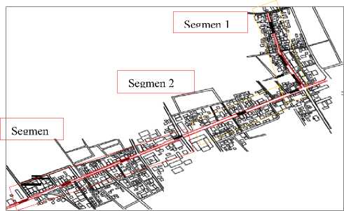
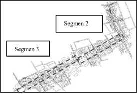
Fig. 1 Pedestrian Line Segment
In reviewing the characteristics of the pedestrian paths on Jalan Ahmad Yani and Diponegoro, what is meant is dimensions, pavement materials used, supporting facilities and others. The pedestrian path at the research site is always active, from morning to evening users pass through this pedestrian path.
After observing segment 1, this pedestrian path is more dominated by shopping and market areas with a pedestrian path dimension of 1.8m wide. The pavement material used
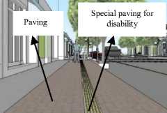
is paving block with a size of 20x20 and several points using ceramics with a size of 30x30. Supporting facilities are available such as parking for 4-wheeled and 2-wheeled vehicles, pergolas, shade tree pots and decorative lights mounted on shade trees. This pedestrian path has not been equipped with a special path for the disabled.
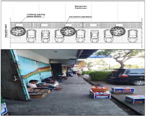
Fig. 2 Pedestrian Line Segment 1
In segment 2, this pedestrian path has a width of 1.6-2 m. The pavement material used is paving block with a size of 20x20. Supporting facilities available such as shelters, pergolas, and some spots look shady because they are equipped with shade trees and planting boxes for ornamental plants. This pedestrian path is not yet equipped with lighting, as well as special lanes for the disabled.
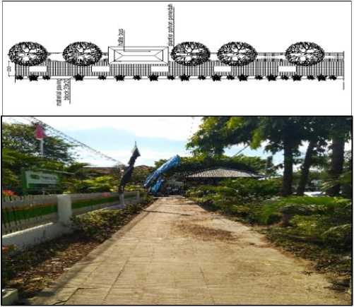
Fig. 3 Pedestrian Line Segment 2
The pedestrian path in segment 3 has a dimension of 1.8m, using various materials at several points such as using paving blocks with a size of 20x20 cm, reinforced concrete and ceramics with a motif size of 30x30. This pedestrian path has been equipped with supporting facilities such as trash cans and railings. However, this segment has not been equipped with special lanes for people with disabilities and
lighting for pedestrian paths.
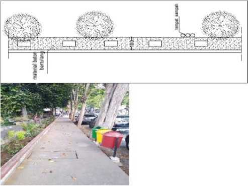
Fig. 3 Pedestrian Line Segment 3
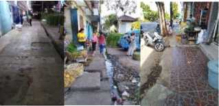
From the results of research at the study sites that have been carried out, the pedestrian paths on Jalan Diponegoro and Ahmad Yani have different dimensions, namely 1.8m-2m, with the material used varies at several points of the pedestrian path such as paving blocks. with a size of 20cm x 20cm, a ceramic motif of 30cm x 30cm and cast concrete, this happened because there was no repair that caused the shop owner to replace the pedestrian path material. while the supporting facilities provided are only planter boxes, shelters and shade plants. Activities on the pedestrian paths on Diponegoro and Ahmad Yani roads are quite dense for users, peaking in the morning and evening on weekdays and holidays. The condition of the pedestrian path at several points is damaged and some shop owners deliberately display their wares across the boundary of the pedestrian path so as to make pedestrians feel uncomfortable. In addition, many pedestrian paths are also converted as selling points by traders, thereby reducing the dimensions of pedestrian paths and parking lots by visitors and shop owners, due to the lack of parking space currently available.
The pedestrian paths on Diponegoro and Ahmad Yani roads are still not accompanied by the use of special materials for persons with disabilities, although they are equipped with ramps, the existing ramps still need to be repaired, because they are misused by motorcyclists who ride the pedestrian paths. The dimensions of the pedestrian path at some points are reduced due to street vendors displaying merchandise and improper placement of electric poles, therefore a pedestrian path concept is needed which can later provide a structuring concept in accordance with the behavior of its users, so that there is no transfer of function pedestrian path.
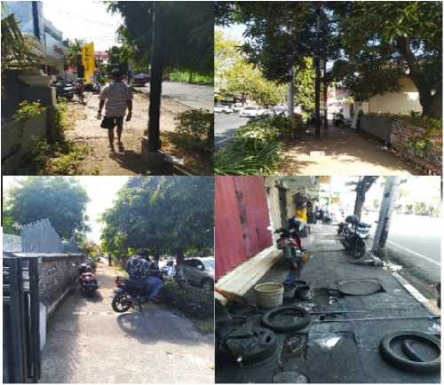
Fig. 4 The Condition Of The Pedestrian Route That Transferred To Function
-
B. Analysis of Pedestrian Characteristics
From the results of observations made through the Behavioral Mapping method on pedestrian paths in Singaraja City Center which was observed in the morning at 08.00-17.00 WIB and in the afternoon at 19.00-22.00 WIB and was observed repeatedly every 15 minutes changing spots and repeated every day at 12.00 WIB. the same, namely: weekdays (Monday, Tuesday, Wednesday, Thursday, Friday), and holidays (Saturday, Sunday, red date) by marking the behavior on the map provided, it was found that the composition/number of users seen from the behavior and movement of users did not always the same, the user behavior mapping sketch is quite clear to see the difference, both in the morning and at night.
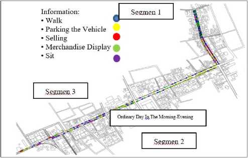
Fig. 5 Mapping the behavior of ordinary day users in the morning-evening
people behavior of users displaying merchandise, 60-90 people behavior of users parking their vehicles. In addition, there is also the behavior of sitting on the pedestrian path on
Jalan Ahmad Yani and Diponegoro.
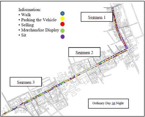
Fig. 6 Mapping the behavior of ordinary day users Ordinary Day At Night
From the data obtained using behavioral mapping techniques in Figure 6, namely on weekdays at night on the pedestrian paths Jalan Ahmad Yani and Diponegoro are dominated by the behavior of pedestrians, vehicle parking and trading, with an average of 10-70 people per day. . pedestrians, trading behavior 10-50 people, vehicle parking behavior 20-80 people.
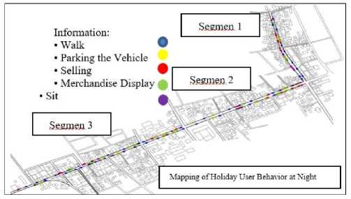
Fig. 7 Mapping of Holiday User Behavior at Night
By using behavioral mapping techniques observed in the prepared map in Figure 7, it was found that on holidays at night the behavior was dominated by walking, parking vehicles and selling, with an average of 10-80 people per day. parking behavior, 10-50 people walking user behavior and 10-20 people selling user behavior.
After being analyzed in each segment using behavioral mapping techniques, namely marking the observed behavior on a map that has been prepared for two full months, on weekdays from morning to evening on the pedestrian paths Jalan Ahmad Yani and Diponegoro are dominated by the behavior of users walking ,displaying merchandise and parked vehicles. The data obtained on average per day reaches 50-100 people behavior of users walking, 40-80
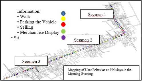
Fig. 8 Mapping of User Behavior on Holidays in the Morning-Evening
After being analyzed in each segment using behavioral mapping techniques, namely marking the observed behavior on a map that has been prepared for two full months, on weekdays from morning
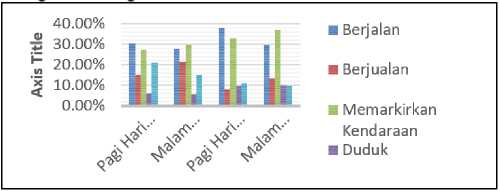
Fig. 9 Percentage of Number of Pedestrian Users on Jalan Ahmad Yani and Diponegor
From the diagram above, it can be concluded that in the morning and evening on weekdays the Ahmad Yani and Diponegoro roads are dominated by pedestrians with a percentage of 30%, 27% of users park their vehicles on the pedestrian path, then 21% of road users. users display merchandise, and at night on weekdays it is dominated by vehicle parking behavior on pedestrian paths with a percentage of 29%, walking behavior as much as 27%, then selling behavior 21%. Meanwhile, on holidays in the morning and evening, walking behavior is dominated by 38%, vehicle parking behavior is 32%, and merchandise display behavior is 11%, and at night on holidays, vehicle parking behavior is 37%. foot as much as 29% and selling behavior as much as 13% on the pedestrian path. This shows that the behavior of users walking on pedestrian paths in Singaraja City is dominated in the morning on weekdays and holidays, while selling behavior on pedestrian paths only occurs at night on weekdays and holidays and tends to occur in segments 2 and 3. The behavior of users parking their vehicles on the pedestrian path is highest when compared to the behavior of users displaying merchandise and buying and selling that occurs in the morning and evening. For the behavior of users who display merchandise on the pedestrian path tends to occur in the morning to evening on weekdays, while at night and on holidays the behavior of shop owners displaying merchandise decreases, this is because the shop is closed at night and on holidays.
From the results of interviews with users of pedestrian paths on Jalan Ahmad Yani and Diponegoro, pedestrian
behavior feels less comfortable using the pedestrian path, due to the transfer of functions and behavioral deviations on the pedestrian path which is used as a parking lot, selling and displaying merchandise by shop owners. , from the data obtained, this occurs due to the lack of available parking spaces, both from the government, and from shop owners in providing parking spaces for visitors. The behavior of traders who sell on pedestrian paths has actually long been prohibited by the Singaraja City Government because the function of pedestrians in general is for pedestrians, but what happens on the contrary is the space for pedestrians is getting narrower because of their existence. From the survey results, this is due to the unavailability of land for them to sell in the market, and this is due to the Banyuasri market, which was the place for selling traders previously, which is currently being renovated. This is also due to the behavior of buyers who prefer to buy the merchandise of street vendors because it shortens their time when shopping where pedestrians who use the pedestrian path are mostly housewives, traders/entrepreneurs and office employees who like a more effective time when shopping. . It can be concluded that the concept of a pedestrian path in the center of Singaraja City is not in accordance with the current behavior of its users, because there are still many functions changing due to behavior that is not in accordance with the function of the pedestrian path. In addition, the lack of clear boundaries in displaying merchandise caused by the replacement of the pedestrian path material which is the same as the shop owner's building, this is what causes pedestrian comfort to be disturbed.
-
C. Factors that cause the Incompatibility of the Pedestrian Path Concept to the Behavior of its Users in the Singaraja City Center
From the results of the analysis of physical conditions and user behavior that are interrelated using behavioral mapping techniques, it is focused on behaviors that are not in accordance with the function of the pedestrian path, including: parking vehicles on the pedestrian path, selling, displaying merchandise and crossing not in the places that have been provided. . The two analyzes resulted in several factors causing the inappropriateness of the pedestrian path concept in the center of Singaraja City to the behavior of its users as follows.
TABEL I
FACTORS CAUSING INCOMPATIBILITY WITH THE CONCEPT OF PEDESTRIAN PATHS IN SINGARAJA CITY CENTER JALAN AHMAD YANI AND DIPONEGORO
Factor From the results of interviews with users who park
Physical condition their vehicles on the pedestrian path due to the lack
of parking space provided, it causes some people to park their vehicles on the pedestrian path.
The results of interviews with users who sell on the pedestrian path due to the lack of a selling area for traders cause traders to choose to sell on the pedestrian path.
The arrangement of supporting facilities is not
paid attention to, causing some pedestrian paths to be blocked by electric pole foundations, street lighting foundations, inappropriate pavement materials, and the lack of supporting facilities such as seats (observations). According to Rubenstein (1992), in the design of pedestrian paths, it must also be equipped with street furniture, one of which is park benches as a place to rest for pedestrians.
The boundary between the pedestrian path and the shop area is unclear due to the replacement of the same pavement material as the shop area, so that some shop owners display their wares to cross the pedestrian path. (Interview result)
From the results of field observations, the surface of pedestrian paths, leveling and ramps still need to be improved and the addition of special pavements for people with disabilities.
Unclear crossing conditions result in pedestrian path users who want to cross not using the crossing facilities that have been provided. (results of observations and interviews)
Physical condition Crossing out of place
Behavioral factors
(non physical)
Some motorists park their vehicles on the pedestrian path.
Selling on the pedestrian path
Some shop owners display merchandise to the pedestrian path
-
D. Factors that cause the Incompatibility of the Pedestrian Path Concept to the Behavior of its Users in the Singaraja City Center
After analysis of the two data, namely the characteristics and behavior of pedestrian path users in Singaraja City, it produces data that are related to one another, resulting in a concept in structuring pedestrian path comfort in accordance with the behavior of its users
TABEL II
THE CONCEPT OF STRUCTURING THE COMFORT OF
of pedestrian lane leveling is also done to prevent motorized vehicles from accessing the pedestrian path as a parking space.
- It is necessary to add supporting facilities such as seats. This is because the data obtained from pedestrian path users in Singaraja City, on average, are 30-50 years old and above, where that age requires more resting places than the age of users under 30 years.
Crossing facilities
The need for additional zebra crossings and also pelica crosses in segment 1 and segment 3, this is due to the existence of a market where the intensity of pedestrian users in that segment is higher. In addition, it is also necessary to arrange the placement of planter boxes and parking areas so that pedestrians
feel safe and comfortable when accessing
crossing facilities.
Traders who sell on - The need for additional space for street
pedestrian paths vendors who sell there is a pedestrian path
and the role of the Singaraja City
government, especially the Ministry of Public Works and Public Housing (PUPR) in paying attention to the need for space for traders where they used to sell are currently undergoing renovations.
- Planning a marketing strategy for the relocation of street vendors as an effort to increase the turnover of street vendors.
PEDESTRIAN PATHS IN SINGARAJA CITY
Aspects to be arranged Paving, leveling and supporting facilities (park benches) Pedestrian Trail
Concept idea
- It is necessary to make improvements and replacement of cast concrete materials and damaged pedestrian paths with paving. Paving was chosen with the following considerations in mind, it is stronger and more durable, easy to replace when damage occurs, has gaps/cavities to drain water and absorb water into the soil, has a rough surface so it doesn't slip As well as the addition of special materials for people with disabilities by using paving that has a special texture.
Displaying merchandise to the pedestrian path.
- The need for a strict zone for actors who
display merchandise to the pedestrian path by providing different pavement materials so that the zone between the shop yard and the pedestrian path is clearer. This is expected to provide clarity of the zone so that there is no display of merchandise to the pedestrian path.
- Not only paving replacement, the addition
Park the vehicle on the pedestrian path
-
- The need for additional parking areas in segments 2 and 3 by making on-street parking so that it can reduce behavior in parking vehicles on pedestrian paths.
-
- Firmness is needed for the government of the Ministry of Public Works and Public Housing (PUPR) in granting a permit to build a shop that must have an adequate parking area for employees and shop visitors.
From the results of data and analysis of observations carried out for 2 full months at the location, namely on Jalan Diponegoro and Ahmad Yani in Singaraja City Center, it was concluded that the problems that occurred on the pedestrian path on Jalan Diponegoro and Ahmad Yani. The characteristics of the pedestrian paths on Jalan Diponegoro and Ahmad Yani in Singaraja City Center have various variations in terms of supporting facilities, materials and dimensions. Several points in each segment at the research location used paving block pavement materials, ceramic motifs, cast concrete, along the pedestrian path on Diponegoro and Ahmad Yani roads. In terms of supporting facilities in each segment, there are still no seats, lighting
and no special pavement for people with disabilities, but some points have been equipped with pergolas, shade trees, signage, trash cans and bus stops. Several points of pedestrian paths in Siingaraja City Center are in a badly damaged condition and have potholes. Pedestrian paths at several points in each segment occur due to user factors, namely parking vehicles, selling, and displaying merchandise. This shows that the pedestrian path in Singaraja City is currently not in accordance with the behavior of its users. Meanwhile, from the data and analyzing user behavior that has been carried out on pedestrian paths in Singaraja City by using behavioral mapping techniques for several behaviors such as: walking, parking vehicles, selling, displaying merchandise and sitting. Meanwhile, some behaviors that are included in the conversion of pedestrian lanes include parking vehicles on pedestrian paths, displaying merchandise on pedestrian paths, selling on pedestrian paths, crossing inappropriately.
The factors that cause the incompatibility of the concept of the pedestrian path in Singaraja City with the behavior of its users are the physical condition factors at the research location including; lack of available parking space, replacement of pavement on pedestrian paths using the same kramik motif used by shop owners so that shop owners freely display their wares, lack of pedestrian path restrictions so that motorists cannot pass through the pedestrian path to mark their vehicles , lack of land for traders who have been selling on the pedestrian path for a long time or those who are new to selling on the pedestrian path because their market is still in the development stage, lack of clarity about accessibility and additional crossing facilities provided, as well as the addition and addition of facilities in several pedestrian lanes. feet that are still the point of less attention. While the behavioral factors of users who have not obeyed the rules and paid less attention to the impact of the violations committed, which will harm pedestrians in terms of comfort and safety.
From the condition of the pedestrian path that has been observed at the research location in Singaraja City, several concepts of pedestrian comfort on Jalan Diponegoro and Ahmad Yani that can be given are: paths that are not in accordance with standards ranging from pavement materials and the availability of supporting facilities, the need for bags to be provided. parking pockets at several points of the pedestrian path, the need for attention in terms of the pavement material used on the pedestrian path to comply with the standards, as well as the need for additional leveling and pedestrian path barriers (Bollards), and available crossing facilities so that they are more considered and placed, and the need to be equipped with a pelica cross so that users feel comfortable in using it.
References
-
[1] Badan Pusat Statistik. 2015. http://bps.go.id. Diakses pada tanggal 5 Mei 2020 pada pukul 17.00 WIB.
-
[2] Danoe, Iswanto, 2006. Pengaruh Elemen- Elemen Pelengkap Jalur Pedestrian Terhadap Kenyamanan Pejalan Kaki (Studi Kasus: Penggal Jalan Pandanaran, Dimulai dari Jalan Randusari Hingga Kawasan Tugu Muda)..Artikel Jurnal Ilmiah Perancangan Kota dan Permukiman, Volume 5 Nomor 1Edisi Maret 2006, Bandung.
-
[3] Lang, John. 1994. Urban Design : The American Experience. New York : Van Nostrand Reinhold
-
[4] Utterman, RK. 1984. Accomodating The Pedestrian. New York: Van Nostrad Reinhold Co.
-
[5] Haris dan Ullman, 1945, dalam buku Struktur Tata Ruang Kota, Pustaka Pelajar, Yogyakarta.
-
[6] Sabari, Hadi Yunus, 2000, Struktur Tata Ruang Kota, Pustaka Pelajar, Yogyakarta.
-
[7] Rubenstein, Harvey M. 1992. Pedestrian Malls, Streetcapes, and Urban Spaces. John Wiiley and Sons: USA.
-
[8] Anggriani Niniek, 2009, Pendestrian Ways Dalam Perancangan Kota, Cetakan pertama, Klaten : Yayasan Humaniora.
-
[9] Sommer, R, Sommer, B, 1980, A Practical Guide to Behavioral Research, Tools and Techniques, Oxford University Press, New York.
Discussion and feedback