Augmented Reality Application for Sink Location Information in Niti Mandala Renon Field
on
p-ISSN: 2301-5373
e-ISSN: 2654-5101
Jurnal Elektronik Ilmu Komputer Udayana
Volume 9 No. 4, May 2021
Augmented Reality Application for Sink Location Information in Niti Mandala Renon Field
Diky Rizky Awana1, Agus Muliantaraa2
aInformatics Department, Udayana University
Bali, Indonesia 1dikyrizkyawan@gmail.com 2muliantara@unud.ac.id
Abstract
Currently, the whole world is experiencing a pandemic outbreak of the COVID-19 virus, which is an infectious disease that is one of the types of coronavirus. Transmission of this virus can go through the surrounding goods that are touched by the hand so it is recommended to always maintain hand hygiene by washing hands with water and soap. Not at every entrance in Niti Mandala Renon field, there is a sink and no information about the location of the sink in this field, which can cause the community to be confused due to lack of information. Augmented Reality (AR) applications can be used to solve this problem because with AR can explain more interactive information because the information displayed through 3D objects is directly applied to the real world visually. In this case, AR is used to display the map of sink location information with an interactive 3D model that can be rotated and zoomed to help the community easily get the information. This application use marker-based AR with multi-target so that each map information is stored and display on the different marker. Users only need to install the application on their android device and scan the QR code provided, then the 3D map object will be displayed according to the registered marker. Based on testing this study gets a 100% success rate in functional aspects.
Keywords: Map, Augmented Reality, Unity, Vuforia, Android, Marker Based .
Currently, the whole world is experiencing a pandemic outbreak of the COVID-19 virus, which is an infectious disease that is one of the types of coronavirus. People infected with the COVID-19 virus can experience respiratory diseases and recover without the need for special treatment. However, the elderly and those with medical problems are more likely to develop serious diseases. Transmission of this virus can go through a person's saliva droplet when sneezing or coughing. Transmission of this virus can also go through the surrounding goods that are touched by the hand so it is recommended to always maintain hand hygiene by washing hands with water and soap. Because water and soap can kill this virus that is on the hands. [1]
Currently, Indonesia has entered a new normal era where the government requires every activity to continue to use health protocols, namely by maintaining physical distance, using masks, and always washing hands, especially in public facilities. Where the government has increased the number of sinks in public facilities because in this facility is prone to transmission.
Niti Mandala Renon field has been provided sink as a public facility. However, not at every entrance, there is a sink and no information about the location of the sink in this field, which can cause the community to be confused due to lack of information and unable to wash their hands. Therefore, the community needs a solution to deal with this problem.
Based on the journal “Augmented Reality Peta Informasi Jalan di Kota Pontianak” [2] which builds an augmented reality (AR) application that displays a road information map in Pontianak City. Based on the test results obtained a percentage result of 95.33% which shows that this application can be used as interesting information and a percentage of 92.74% that indicates that this application can be easily used by the public.
Based on these problems and literature, AR applications can be used to solve this problem because with AR can explain more interactive information because the information displayed through 3D objects is directly applied to the real world visually.
The data used in this study was obtained by direct observation in Niti Mandala Renon field. Data obtained from the observations are field map data and location data and the number of sinks.
This study using the waterfall model for the System Development Life Cycle (SDLC). The feature of the waterfall model is its sequential steps. The waterfall model is a model where each stage must be completed before starting the next stage [3].
a Software Requirements
Marker-based Augmented Reality (AR) is used to build this app. The object to be displayed is a 3D map containing information about the location of each sink in Niti Mandala Renon field. The 3D map objects created are 3 pieces namely the north, west, and east entrance. Each map is defined by one marker so it can be said this application is multi-target. The app is built on the Android operating system and built using unity software with Vuforia, which is an AR development library.
b Software Input and Output
The required input from this application is a marker that is used to determine the position for the 3D object to be displayed. Markers used in this application are QR codes. The output of this application is the 3D map object and correct according to the registered marker.
c Software Limitation
The limitations of this application are that this application only displays a map of the sink location at the north, east, and west entrances of Niti Mandala Renon field. This application can only run on the android operating system with minimum version 4.1 Jelly Bean.
Software design is the stage at which developers start designing software to meet every need from the previous analysis. The design model for this app are as follows,
a Software Technology
The technology used in this study is marker-based Augmented Reality (AR) with multitarget which is a method of detecting multiple target markers for multiple objects simultaneously. The application is built using Unity Game Engine with Vuforia as an Augmented Reality development library. The flowchart model for this application is described as follows,
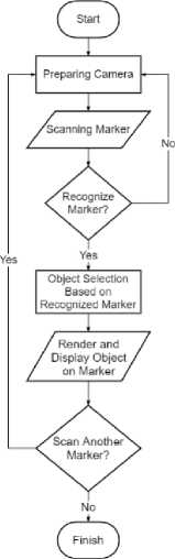
Figure 1 Flowchart Design of Multi-Target Marker AR
From the flowchart, you can see the first step is to set up the camera to track markers. If the marker is successfully recognized, the process of selecting the object according to the marker on the database will be performed. Then the object will be rendered and displayed on the marker. This process will be repeated to the first step if the detected marker is missing.
b Software Functional Model
Use case diagrams are a modeling tool for describing the expected functionality of a system. This model describes the system requirements from the user's point of view, focusing on the computerized process [4]. The use case diagram in developing this application is as follows,
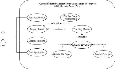
Figure 2 Application Use Case Diagram
Based on the use case diagram described above, the activity diagram of the application can be determined. The activity diagram of this application is described as follows,
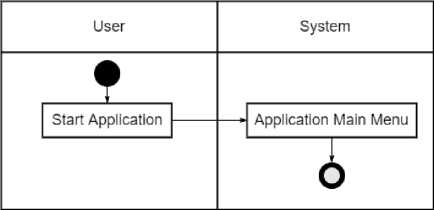
Figure 3 Activity Diagram Start Application
The activity diagram above shows the process when the user accesses the application. Then the application system will display the splash screen, then display the Main Menu.
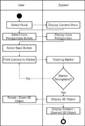
Figure 4 Activity Diagram Mulai Menu
The activity diagram above shows the process when the user selects Mulai menu from Main Menu. Then the system will set up the camera and displays menus containing the back button and Cara Penggunaan button. When the user selects the Cara Penggunaan button, the system will display the Cara Penggunaan menu which contains information about how to use the application. In the Cara Penggunaan menu if user selects the back button then user will return to the camera menu. In the camera menu if the user points the camera towards the marker and the system recognizes the marker, the system will display the 3D object according to the registered marker. User can interact with 3D objects with the rotate and zoom features then the system will move the 3D object according to user input.
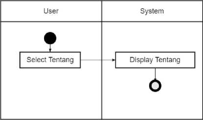
Figure 5 Activity Diagram Tentang Menu
The activity diagram above shows the process when user selects Tentang menu from Main Menu. Then the system will respond by displaying Tentang menu which contains information about the application and the developer.
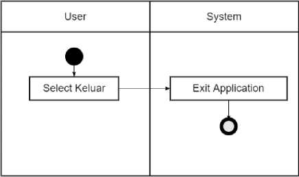
Figure 6 Activity Diagram Close Application
The activity diagram above shows the process when user selects Keluar menu from Main Menu. Then the system will close the application.
The application implementation contains screenshots of the application that has been built. The following sections are,
-
a. Main Menu
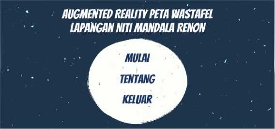
Figure 7 Main Menu
-
b. Tentang Menu
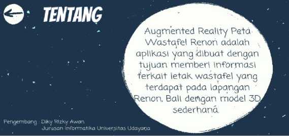
Figure 8 About Menu
-
c. Mulai Display
Figure 9 AR Menu Display
d.
Cara Penggunaan Menu
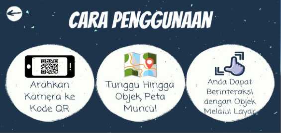
Figure 10 Cara Penggunaan Menu Display
e. AR Object Map Display
1. North Entrance Display

Figure 11 North Entrance Display
2. West Entrance Display
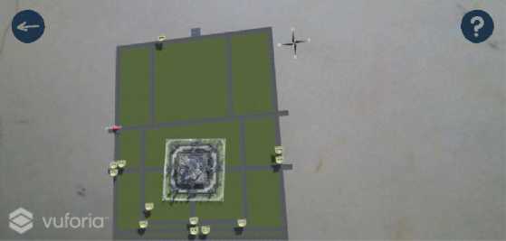
Figure 12 West Entrance Display
-
3. East Entrance
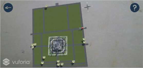
Figure 13 East Entrance Display
f. AR Object Rotate and Zoom-In Display

Figure 14 AR Object Rotate and Zoom Display
Tests carried out for this application are using blackbox testing, Which is a testing method that focuses only on the functionality of the application. This test is done by running the app on several different devices. Test devices used include Oppo A83, Xiaomi Mi 9T Pro, Xiaomi Redmi K20Pro, Huawei Nova 5T, and Samsung A10. From the test process, the following data is obtained.
Table 1 Pengujian Blackbox Aplikasi
|
No |
Testing |
Description |
Result |
|
1 |
Start the application |
Displaying the Main Menu |
Success |
|
2 |
Select Mulai menu |
Set up the camera and displaying back button and Cara Penggunaan button |
Success |
|
3 |
Select Cara Penggunaan button |
Displaying how to use the application |
Success |
|
4 |
Tracking the marker |
Displaying AR 3D map on the marker and true according to the registered marker |
Success |
|
5 |
Zoom the 3D object |
Displaying zoomed 3D object |
Success |
|
6 |
Rotate the 3D object |
Displaying rotated 3D object |
Success |
|
7 |
Select Tentang menu |
Displaying information about the application |
Success |
|
8 |
Select back button |
Displaying the previous menu |
Success |
|
9 |
Select Keluar menu |
Close the application |
Success |
The Augmented Reality Application for Sink Location Information at Niti Mandala Renon was built to address the lack of information regarding the location of sinks throughout the field. The technology used in this application is marker-based Augmented Reality with multi-target, which has input of several QR code markers and output in the form of several objects 3D map sink. The application is built using Unity Game Engine with Vuforia as an Augmented Reality development library. The design of the application uses the waterfall model as its System Development Life Cycle (SDLC) method. Based on the results of blackbox testing obtained functional results the application can run well on several different devices.
References
-
[1] WHO, “World Health Organization,” [Online]. Available: www.who.int. [25 September 2020].
-
[2] A. S. T. Guntur, A. S. Sukamto e H. Muhardi, “Augmented Reality Peta Iinformasi Jalan di Kota Pontianak,” Jurnal Sistem dan Teknologi Informasi, Vol.7, No.4, p.235-241, 2019.
-
[3] A. Alshamrani and A. Bahattab, “A Comparison Between Three SDLC Models Waterfall Model, Spiral Model, and Incremental/Iterative Model,” International Journal of Computer Science Issues, Vol.12, No.1, p.106-111, 2015.
-
[4] D. A. P. P. Sanjani, P. N. Crisnapati, I. M. A. Wirawan and I. G. M. Darmawiguna, “Pengembangan Aplikasi Pengenalan Gedung Universitas Pendidikan Ganesha Berbasis Markerless Augmented Reality,” Kumpulan Artikel Mahasiswa Pendidikan Teknik Informatika, No.1, p.7-17, 2015.
456
Discussion and feedback