THE APPLICATION OF REMOTE SENSING IN TOURISM AT NUSA DUA TOURIST RESORT OF BALI ISLAND
on
Ecotrophic ♦ 4 (1): 43-48 issn: 1907-5626
THE APPLICATION OF REMOTE SENSING IN TOURISM AT NUSA DUA TOURIST RESORTOF BALI ISLAND
Putu Gede Eka Darmaputra 1), and I Wayan Redi Aryanta 2)
-
1) Bali Tourism Institute Nusa Dua Bali
-
2) Master Program of Environment Science Postgraduate Program Udayana University
Email: pmil-unud@indo.net.id
ABSTRACT
The aim of this research is to determine the tourist products and to know whether the visual interpretation of remote sensing and GIS tecnology can be applied in tourism in Nusa Dua Tourist Resort. In the preparation stage, it is necessary to combine data ALOS satellite image with identity ALAV2A044933780 with map, and followed with visual interpretation of satellite image to obtain temporary results concerning tourist products in Nusa Dua tourist resort. The result of satellite visual interpretation was cross checked by insite observations to compare the potentials of coral reef at sea and tourist product on the ground. The combination visual interpretation of satellite image and in site observation of tourist product in Nusa Dua tourist resort enables to obtain spatial mapping for tourism in Nusa Dua tourist resort
Key word: Visual Interpretation, GIS, coral reef, tourism, tourist product
ABSTRAK
Penelitian ini bertujuan untuk menentukan produk pariwisata serta untuk mengetahui apakah interpretasi visual dari penginderaan jauh dan teknologi SIG dapat diterapkan untuk pariwisata di kawasan wisata Nusa Dua. Pada tahap awal, sangat perlu menggabungkan data citra satelit ALOS, ALAV2A044933780 dengan peta rupa bumi, dilanjutkan dengan menginterpretasikan secara visual citra satelit sehingga mendapatkan hasil sementara produk pariwisata di kawasan wisata Nusa Dua. Hasil sementara dari interpretasi secara visual akan di cek ulang dengan hasil melakukan observasi di lapangan untuk mencari perbandingan potensi terumbu karang di laut dan produk pariwisata di darat. Kegiatan mengkombinasikan hasil interpretasi secara visual dari citra satelit dan hasil observasi langsung produk pariwisata di kawasan wisata Nusa Dua dapat membantu memetakan informasi pariwisata di kawasan wisata Nusa Dua.
Kata Kunci: Interpretasi Visual, ,SIG,terumbu karang, pariwisata, produk pariwisata
INTRODUCTION
Tourism has been considered to be one of crucial industries in the world (Baker, et.al,1994) so that the people who intend to travel to different places as tourists, need to have some information about those places. In addition, knowing the shortest routes to the places of interest and natural beauty from their accommodation will be both save time and money. The combination of Remote Sensing Technology and Geographical Information System provides tourists with these possibilities. As the center for tourism development in Indonesia as well as one of the world tourist destinations, Bali has great potentials to be further developed its nature, human and culture into a better tourist destination.
The rapid development of world’s tourism and the trend in tourism movtivation in which tourists are searching for unique destination in turm of culture, natural resources, has given opportunities for Bali to attract more tourists (Bali Government Tourism Office, 2007).
Unfortunately, there are many potentials of coastal resources has not been developed and identified optimally. However, the technology of remote sensing can help determine coastal potentials of Bali in a considerably short time.
Nusa Dua tourist resort is a famous international tourist resort located in the southen part of Bali island. Bali Government Tourist Office (2007) reports that in 2007 the number of tourists visiting Bali directly was 1.664 854, and 562 178 tourists visited Nusa Dua Tourist resort. In other words, 33,8% of the tourists visiting Bali stayed in Nusa Dua. As an internationally recogized tourist resort, it offers many tourists’ accomodation, restaurant and bar, spa and massage and tourist atractions such as natural beaches and underwater world such as various coral reef. Number of tourists visits to Nusa Dua can be seen in Figure 1:
Problem Statement
The present study seeks to answer the following research questions:
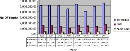
Figure 1. Tourist Arrival
-
2. Giving information concerning tourist products in Nusa Dua Tourist Resort, using GIS
-
3. Giving the information for tourists who come to Nusa Dua Tourist Resort.
-
4. Giving the information concerning tourist products offered in Nusa Dua Tourist Resort.
-
5. Giving the information concerning the distance to some tourist products.
RESEARCH METHODOLOGY
-
1. Whether the visual interpretation of remote sensing tecnology and GIS technology can be applied for tourism?
-
2. How the method of visual interpretation of remote sensing can identify tourist products in Nusa Dua area?
-
3. Can the remote sensing be used as one of tourist information sources in the future?
Aim and Objectives
The objectives of this research are as follows:
-
1 .To know whether the visual interpretation of remote sensing technology and GIS tecnology can be applied for tourism.
-
2 .To determine the tourist products in Nusa Dua Tourist Resort by using visual interpretation of remote sensing
-
3 .To know the possibility whether remote sensing can be used as one of tourist information sources in the future
Research Benefit
The result of this study have following benefit:
-
1. Giving the information on if the remote sensing and GIS technology are able to be applied for tourism.
Spatial Map for Tourism
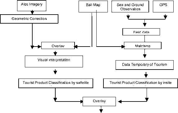
Figure 2: Research Methodology for Obtaining spatial mapping for tourism using visual interpretation
Obtaining the information of tourism product using remote sensing technology is possible because the application of this technology is widely recognized recently. In the preparation stage, it is necessary to combine data satellite imagery with map, in this case is the map of Bali and Nusa Dua. Geometric correction was used firstly to obtain the right position of the area, and followed with visual interpretation of satellite image to obtain temporary results concerning tourist products in Nusa Dua tourist resort. The result of satellite visual interpretation was cross checked by insite observations to compare the potentials of coral reef at sea and tourist product on the ground. The combination visual interpretation of satellite image and in site observation of tourist product in Nusa Dua tourist resort enables to obtain spatial mapping for tourism in Nusa Dua tourist resort. For futher explanation, it can be seen the scheme of research methodology in Figure 2 :
This research was conducted in Nusa Dua Tourist Resort, Badung, Bali. This area is located in southern part of Bali where many activities and facilities for tourists are provided and tourism is the main income generating sector for the people. The area lies from Tanjung Benoa beach in the north to Sawangan beach in the south.
The research was conducted from February until May 2008, and the sea survey was done in early April 2008. The data collected for this study can be devided into two categories of primary and secondary data (Zang, 2001). The primary data are imagery of data ALOS satelite and field data of the sea and the ground. The secondary data are information of tourist objects, interesting places and also the number of accomodation in Nusa Dua Tourist Resort. The conclusion for this research is drawn from the analysis of the data submitted from imagery of ALOS satelite, with identity scene ID: ALAV2A044933780 and the data from sensor AVNIR-2, with the observation dated on 20061128. The satelite ALOS was tracking above Nusa Dua area on November 28th 2006.
Other field data, especially data from the sea, was cross checked with Manta Tow survey and Line Intercept Transec (LIT). The aim of Manta Tow survey was to
determine condition of coral reef in general. It was followed by another method, called LIT with the aim to check the quality of coral reef directly by scuba diving.
Research Instruments / Data collection
The data collection for this research are as follows :
-
1. Directory of hotels, homestays and tourist resorts and object from Tourist Data Base of Tourism Government Authority of Bali
-
2. Data satellite ALOS
-
3. Data collection through scuba diving
Scuba diving was conducted to collect the primary data about coral reef coverage. He data are analysed by remote sensing and software application like Arc-view GIS version 3.1 and also microsoft office
Research Procedure
Preparation ( Pre Processing)
The image was prepared to be analyzed. Geometric corrections are done to repair geometric distortion, to return the image into correct position, and to separate the area. Base on ALOS image, the data coverage is 70 X 70 km which is wider than the research location. Image cropping was done to adjust the image.
Process
Reading the image. Visual Interpretation Processing is used in this research. The visual interpretation of the sattelite image is the extraction of qualitative and quantitative information in the form of a map about shape, colour, location, texture, function, relationship between objects. Ground investigation known as insite observation is necessary.
Data Análysis ( Post Process)
Recording the interpretation to information of tourist product. Using GIS enable to find temporary tourist products in the sea and on the ground. The final result is spatial mapping of tourist products such as accomodation, tourist objects also resort facilities.
RESULT AND DISCUSSION
Interpretation of imagery remote sensing can be done in 2 ways: manually and digitally. Manual interpretation is a way to interprate remote sensing data, based on its characteristics locally. Object characteristics can be identified through eight items of interpretation (Anonim), such as form, size, shape, tone, pattern, shadow, colour, texture, association. Summarily one of them can represent the image interpretation. Based on the imagery ALOS, manually interpreted by identifying the recognized object’s characteristics the object location. Area identification was done based on correction processing of data satelite that is correction geometric combined with map of Bali. Meanwhile, next step correction radiometric was not
neccessary based on an assumption that the imagery of ALOS sattelite is very clear and clean. There was no blocking of cloud to see the object and this research concerned with manual interpretation or visual interpretation in which radiometric correction can be ignored or unnecessary, as it is based on a consideration that the picture on an object is unreflected.
The research in this area is devided into 2 parts of observation that is sea and ground area. Both interpretation of sea and ground used visual interpretation, and supported by directly cross check on the field or insite observation. Manta Tow survey method and Line intersect Transec (LIT) was used to identify the condition of coral reef and fishes community in general. On the ground, it was applied by directly observing the location of hotels, restaurants and bars, spa and massage, tourist object and another resort facilities such as golf courses . Complete description is as follows:
SEA
General condition of Nusa Dua Sea was the flow’s pattern in Nusa Dua coastal affected by the macro flow’s pattern, that was movement of sea in Bali strait, Lombok strait, and Indonesia ocean. Micro flow’s pattern is the flow’s pattern in the narrow sea of Nusa Dua which varies and really affected by the current of sea tidal. The wave in Nusa Dua sea is qualified as high wave as normally found on the characteristic of the sea in south area which faces directly to the Indonesia ocean. Wave frequency entering Nusa Dua coastal is around 3 – 5 wave per minutes with period 12 – 20 seconds. Wave energy reached coast line is around 78,6 – 1.258,0 joule/m. The wave is straight vertical to the coast line, meanwhile in the south, the tendency of wave is creating angle line into the north.
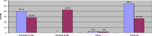
In general, the result of Manta Tow survey presents the live coral covering between 50 – 70%, while in some areas it is less than 25%. In one point of observation area, it was found a very good coral condition with live coral covering is more than 75%. It is one indicator to be developed for diving (Figure 6) (Trisakti, et al. 2004) The analysis of ALOS image shows the spread of coral reef along the Nusa Dua coastal are. This spread of coral reef is a group into barrier reef type in which between the land and coral reef is found a narrow laguna with sea grass. This research apply the line intercept transect method in 3 location points of observation by randomly marking and concerning with standard of researcher’s safety. In the location point 1, at S 08o45’20,55” and E 115o13’30,20”located on the border of Serangan island and Tanjung Benoa, the research presented a procentage of 40,4% covering live coral on the 3 mt sea level, and 28,68% on the 10m sea level. The most dominant found in this area is 54,4% of covering subsrat on the 3 m sea level.
Procentage of covering coral in location point 2 is 69,8% on the 3m sea level and 51.36% on the 10 m. Meanwhile, score of covering dead coral is around 9,5 – 26,4%. Location point 3 has procentage of covering dead coral into 35,04% on the 3m sea level and 38,1% on the 10 m. While, covering live coral is 52,8% into 60,5%
In the location point 1, located on the border of Serangan island and Tanjung Benoa, the research presen the procentage of 40,4% live coral coverage on the 3 meters sea level, and 28,68% on the 10m sea level. The most dominant found in this area is 54,4% of subsrat cavering on the 3 m sea level as seen in Figure 3 Line Intercept Transec Location :
Point I: S 08o45’20,55” E 115o13’30,20”
Point 2: S 08o46’44,72” E 115o13’48,07”
Point 3 :S 08o47’43,06” E 115o14’08,77”
3 m 10 m
Figure 3. Procentage coral coverage at point 1

Karang Hidup
Karang Mati
Other
Subsrat
3 m 10 m
Figure 5 Procentage coral coverage at
Percentage of covering coral in location point 2 is described on Figure 4 which show 69,8% on the 3m sea level and 51.36% on the 10 m. Meanwhile, score of covering dead coral is around 9,5 – 26,4%. Location point 3 has procentage of covering dead coral into 35,04% on the 3m sea level and 38,1% on the 10 m. While, covering live coral is 52,8% into 60,5% as been shown on in Figure 5
Data analysis using line intercept transect method presented on Table 1 describes the highest index varieties discovered in location point 2 on the 10m sea level. The lowest score of domination was found in location point 1 on the 3m sea level.
Table 1 . Coral Analysis using Line Intercept Transect
|
Data Analysis |
Stasiun 1 |
Stasiun 2 |
Stasiun 3 | |||
|
3 meter |
10 meter |
3 meter |
10 meter |
3 meter |
10 meter | |
|
Indek Variety |
1.978399 |
2.3050 |
2.6731119 |
3.5564432 |
2.4907 |
2.6388 |
|
Indek Homogeneity |
0.506387 |
0.8210 |
0.7223768 |
0.9610867 |
0.7497 |
0.8796 |
|
Indek Domination |
0.0803 |
0.2488 |
0.1648 |
0.2638 |
0.2195 |
0.1902 |
|
Indek Mortality |
0.000 |
0.599 |
0.2744 |
0.156 |
0.371 |
0.4191 |
The highest score of mortality that is 0,599 was found in location point 1 on 10 m sea level. While the lowest one is on 3m sea level in this location.
Coral fish analysis in this research display if the highest amount of fish individu was found in location point 3 on 3m sea level, while the lowest one is on 10 m sea level as seen in Table 2
Table 2. Coral Fish using Line Intercept Transect
|
Analisa Data |
Stasiun 1 |
Stasiun 2 |
Stasiun 3 | |||
|
3 meter |
10 meter |
3 meter |
10 meter |
3 meter |
10 meter | |
|
Total Jumlah Individu (s) |
172 |
139 |
204 |
187 |
321 |
95 |
|
Indek of Variety |
2.69 |
2.38 |
3.10 |
2.22 |
3.16 |
2.22 |
|
Indek domination |
0.08 |
0.14 |
0.05 |
0.17 |
0.05 |
0.17 |
|
Indek Homogeneity |
0.89 |
0.84 |
0.92 |
0.81 |
0.88 |
0.77 |
The highest varieties index that is 3,16, was found in location point 3 on the 3 m sea level, while the lowest one found in location point 2 and 3 on 10m sea level.
GROUND
The visual interpretation, is conducted to be able to identify some tourist products such as accomodation facilities that is hotel and losmen, restaurant and bar, spa and massage, resort facilities, and tourist object (Foster,1985). Other objects such as houses and open space can also be identified based on ALOS satellite image.
Accomodation:
ALOS image was used to identify accomodation facilities. Its interpretation is based on some items which are clearly visualised by ALOS image:
-
1. The roof of hotel is identified with some particular characteristics such as red color, long shape, and consistent/ neatly arranged pattern. It obviously differs with other building’s roof, for example houses’ roof tends to be small/short shape, dark red colour, and located unconsistent for pattern.
-
2. Supporting facilities of hotel that is swimming pool is also clearly visualised on the ALOS image. Therefore,
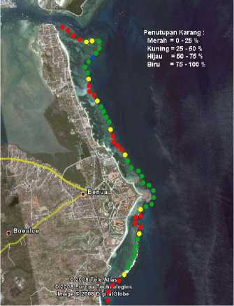
Figure 6: Manta Tow Survey
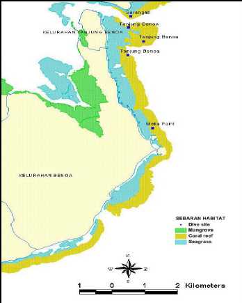
Figure 7 : Four Area for Snorkeling and
Diving
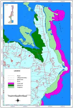
Figure 8.: Coral Reef Coverage and GIS ( temporary tourist product at sea)
the presence of swimming pool strengthen the identification of hotel.
-
3. Normally, hotel area is provided with specific garden that is identified through green colour.
Based on the interpretation of the above items, the hotel location is seen on the top of the image known as Tanjung Benoa and in the bottom is Nusa Dua. Hotel is concentrated in Nusa Dua area on the right side of the image which is located close to the white sandy beach. A small number of hotels is located on the left side bordered by main road.
All those interprated image are star hotels, however only one small hotel can be identified in Tanjung Benoa based on similarity of the roof, that is Hotel Rasa Sayang. Another two small hotels in Tanjung Benoa cannot be identified due to its similarity to the people’s houses.
Other big hotels are also found located far away from the sea, even some of them located in the middle of the image, which through specific observation can be identified because it has very strategic location due to directly facing the sea and harbour.
Restaurant & Bar : Visual Interpretation by identifying the roof of buildings, cannot be applied to restaurant and bar. There is no specific roof of restaurant and bar which is different with another kind of building’s roof, as has been applied to identify hotel. Therefore, it should be checked and observed directly to the location, and usually restaurant and bar is located in the hotels. It is found that restaurant and bar are mostly located in Tanjung Benoa area, located on the left side of the road. Some of
them are located in Mengiat beach in Nusa Dua area, and inside of the big resorts. Besides that, soem are also found along the street of by pass Ngurah Rai.
Spa & Massage : The case of visual interpretation of Spa & massage is the same as Restaurant and bar. It’s difficult to determine the location by identifying the characteristics of the building’s roof, due to it’s similarity to houses’ roof, not too big and the activities is done inside the room. According to the direct observation, there are some Spa and Massage around Tanjung Benoa area and also in ngura Rai street. There are only 2 Spa and Massage located in Jl. Dharmawangsa and Siligita.
Tourist facilities : By applying the visual interpretation, it has been identified some locations of Golf courses as tourist facilities in Nusa Dua area. Golf course has some particular characteristics which can be clearly identified based on the ALOS image, that is specific shape and green color. Green color is reflected neatly and is easily identified as grass field. It’s a wide area with long shape and supported by a pond inside of the field. All these tourist facilitis are found in Nusa Dua area.
Tourist Object : Obviously, there are many tourist objects located in Nusa Dua and Tanjung Benoa area such as Pura Geger, Turtle’s protection area, and white sandy beaches well known as an interesting tourist objects. All of these objects can be identified by using visual interpretation of ALOS image.
The temporary result of tourist products on the ground can be seen in Figure 9 and Figure 10. It shows the statistic of result in site observation on the ground.
This is the final result of the application of remote sensing technology in tourism. The combination between
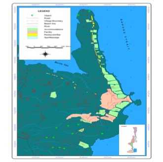
Figure 9 : Tourist Product on the ground by GIS
No of Tourist Product
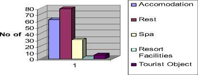
Figure 10 : Number of Tourist Product on the ground of Nusa Dua Tourist Resort
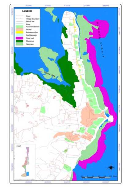
Figure 11. : Spatial Mapping for Tourism by visual interpretation ( it’s combination Figure 8 and Figure 9)
GIS at Sea and GIS at the ground shows the Suggestions
information of tourism such as the best location for snorkeling and diving. Also the GIS of ground show the information of hotel, restaurant and bar, spa and massage, resort facilities and tourist object location as seen in Figure 11.
Remote sensing technology and GIS provide opportunities to be applied into the tourism sector, therefore these technology can be further researched and used to provide tourists with updated information concerning certain tourism destination.
CONCLUSIONS AND SUGGESTIONS
REFERENCES
Conclusions
-
1. The application of remote sensing and Geographic Information System can determine the potentials of tourism both in the sea and on the ground around Nusa Dua. The coverage of coral reef can be found earlier by using remote sensing technology and the potential tourist products on the ground can be valued through this methods.
-
2. Visual interpretation is one of the methods of remote sensing to identify and clasify tourist products in order to manage tourism activites
-
3. The combination of remote sensing and GIS can give clear information concerning tourist product information such as location of accomodation, resort facilities and also tourist object in Nusa Dua tourist resort.
Anonim, Japan Association an Remote Sensing, Remote Sensing Note
Baker. S, and Bradley.P and Huyton, J.1994, Principles of Hotel Front Office Operations A Study Guide British Library Cataloguing-In-Publication Data Cassell London
Bali Government Tourism Office, 2007, Bali in Brief Publisher Denpasar
Dinas Pariwisata Propinsi Bali, 2007, Direktori, Hotel, Pondok Wisata, Rumah Makan, Restauran dan Bar, Biro Perjalanan Wisata Kwasan, Objek dan daya Tarik Wisata , Denpasar
Foster, D. 1985 , Travel and Tourism Management Macmillan Education Ltd London
Trisakti, B, Sucipto U.M and Sari J 2004. Penginderaan Jauh untuk Pengembangan Pariwisata Bahari, (journal) berita Inderaja Lapan Jakarta III (6)
Zhang, J, 2001, Analysis of Coastal Tourism with the Aid of Remote Sensing, 22nd Asian Conference on Remote Sensing Singapore
48
Discussion and feedback